Framed Print > Aerial Photography > Australia
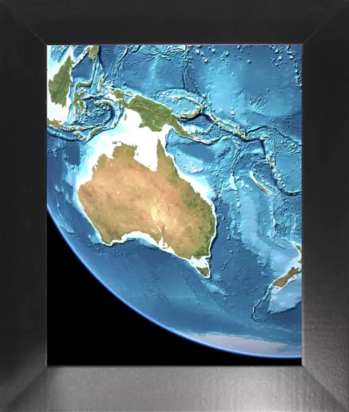
Framed Print : Australia, topographic map


![]()
Framed Photos from Science Photo Library
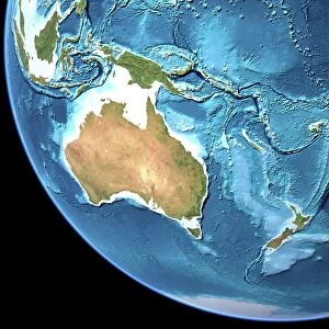
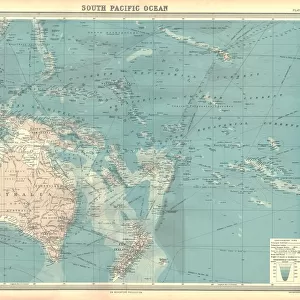
Australia, topographic map
Australia, topographic map. Highlands and lowlands of the continents are shown as ridges and flat areas. Southeast Asia (top left), New Zealand (lower right) and Antarctica (bottom right, white) are also seen, along with the South Pacific Ocean and its various islands (upper right). The seabed depth varies from shallow (light blue) on the continental shelves to deep ocean basins (dark blue). Topographic and bathymetric data is usually gathered by using aerial and satellite imagery combined with radar and sonar mapping. The satellites in this case were NOas POES satellites
Science Photo Library features Science and Medical images including photos and illustrations
Media ID 1705083
© PLANETARY VISIONS LTD/SCIENCE PHOTO LIBRARY
Altimetric Altimetry Australasia Australia Basin Bathymetric Bathymetry Combined Data Continent Continental Shelf Continents Data Depth Depths Floor Globe Highlands Indonesia Island Land Lowlands Malaysia Mapped Mountains New Guinea Oceanic Oceanographic Oceanography Philippines Physical Geography Plains Radar Region Ridge Ridges Round Satellite Satellite Image Sea Bed Sea Floor Shelves Sonar Mapping Sonic South East Asia Southeast Asia Topographic Topography World Island Chain Papua South Pacific Ocean
12"x10" Modern Frame
Discover the beauty and complexity of the land down under with our exquisite range of Framed Prints featuring the Australia Topographic Map by Science Photo Library. This captivating image showcases the diverse terrain of Australia, from the towering mountain ranges and rolling hills of the interior to the flat plains and coastal areas. The intricate details of this map highlight the unique geography of the continent, with the nearby islands of Southeast Asia, New Zealand, and Antarctica also depicted. Bring the wonder of the Australian landscape into your home or office with this stunning and thought-provoking Framed Print.
10x8 Print in an MDF Wooden Frame with 180 gsm Satin Finish Paper. Glazed using shatter proof thin plexi glass. Frame thickness is 1 inch and depth 0.75 inch. Fluted cardboard backing held with clips. Supplied ready to hang with sawtooth hanger and rubber bumpers. Spot clean with a damp cloth. Packaged foam wrapped in a card.
Contemporary Framed and Mounted Prints - Professionally Made and Ready to Hang
Estimated Image Size (if not cropped) is 25.4cm x 25.4cm (10" x 10")
Estimated Product Size is 25.4cm x 30.5cm (10" x 12")
These are individually made so all sizes are approximate
Artwork printed orientated as per the preview above, with landscape (horizontal) or portrait (vertical) orientation to match the source image.
FEATURES IN THESE COLLECTIONS
> Aerial Photography
> Australia
> Aerial Photography
> Related Images
> Animals
> Mammals
> Muridae
> Plains Mouse
> Arts
> Artists
> O
> Oceanic Oceanic
> Asia
> Indonesia
> Related Images
> Asia
> Malaysia
> Related Images
> Asia
> Philippines
> Maps
> Science Photo Library
> Aerial and Satellite
EDITORS COMMENTS
This print showcases the topographic map of Australia, revealing its diverse landscapes and geographical features. The image not only highlights the highlands and lowlands of the continent but also provides a glimpse of neighboring regions such as Southeast Asia, New Zealand, and Antarctica. The South Pacific Ocean with its numerous islands can be seen in the upper right corner. The varying shades of blue represent the seabed depth, ranging from shallow waters on continental shelves to deep ocean basins. To gather this detailed topographic and bathymetric data, a combination of aerial and satellite imagery along with radar and sonar mapping techniques were utilized. In this case, NOas POES satellites played a crucial role in capturing accurate information. This print is an excellent representation of how technology has revolutionized our understanding of Earth's physical geography. It serves as a reminder that advancements in satellite imaging have enabled us to explore even the most remote corners of our planet. With its intricate details and comprehensive mapping, this image offers valuable insights into Australia's landforms while encompassing broader perspectives on regional geography. Science Photo Library has once again provided us with an awe-inspiring visual that celebrates both scientific exploration and our planet's natural beauty.
MADE IN THE USA
Safe Shipping with 30 Day Money Back Guarantee
FREE PERSONALISATION*
We are proud to offer a range of customisation features including Personalised Captions, Color Filters and Picture Zoom Tools
SECURE PAYMENTS
We happily accept a wide range of payment options so you can pay for the things you need in the way that is most convenient for you
* Options may vary by product and licensing agreement. Zoomed Pictures can be adjusted in the Cart.