Framed Print > Maps and Charts > Related Images
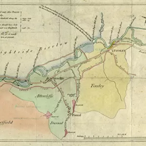
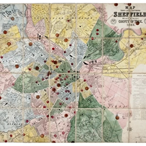
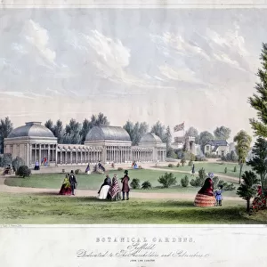
Framed Print : Map of the parish of Sheffield by W. Fairbank and Son (engraved by J. Cary), 1795
, 1795")
, 1795")

![]()
Framed Photos from Sheffield City Archives
Map of the parish of Sheffield by W. Fairbank and Son (engraved by J. Cary), 1795
Scale 3.3 inches : 1 mile.Engraved by J. Cary.Original at Sheffield Local Studies Library:s 127 L; other copies at Sheffield City Archives: FC/She/4L and ACM/She/162
Sheffield City Archives and Local Studies Library has an unrivalled collection of images of Sheffield, England
Media ID 14046217
© Sheffield City Council
18"x14" Modern Frame
Discover the rich history of Sheffield with our stunning Framed Prints from Media Storehouse. This beautiful Map of the Parish of Sheffield, engraved by J. Cary and created by W. Fairbank and Son in 1795, offers a fascinating insight into the layout and boundaries of Sheffield over 200 years ago. With intricate detail and precise engraving, this historical map is a must-have for anyone with a connection to or interest in the city's past. The original map can be found at Sheffield Local Studies Library, and we're proud to offer you a museum-quality reproduction, expertly framed and ready to hang. Bring a piece of Sheffield's history into your home or office and relive the stories of the past.
16x12 Print in an MDF Wooden Frame with 180 gsm Satin Finish Paper. Glazed using shatter proof thin plexiglass. Frame thickness is 1 inch and depth 0.75 inch. Fluted cardboard backing held with clips. Supplied ready to hang with sawtooth hanger and rubber bumpers. Spot clean with a damp cloth. Packaged foam wrapped in a card.
Contemporary Framed and Mounted Prints - Professionally Made and Ready to Hang
Estimated Image Size (if not cropped) is 40.6cm x 35.6cm (16" x 14")
Estimated Product Size is 45.7cm x 35.6cm (18" x 14")
These are individually made so all sizes are approximate
Artwork printed orientated as per the preview above, with landscape (horizontal) orientation to match the source image.
FEATURES IN THESE COLLECTIONS
> Maps and Charts
> Related Images
> Sheffield City Archives
> Maps and Plans
EDITORS COMMENTS
This print showcases the historical "Map of the parish of Sheffield" meticulously crafted by W. Fairbank and Son in 1795. Engraved with utmost precision by J. Cary, this remarkable piece offers a fascinating glimpse into the past, allowing us to traverse through time and explore the intricate details of Sheffield's parish boundaries. With a scale of 3.3 inches to 1 mile, this map provides an exceptional level of accuracy for its era, enabling viewers to immerse themselves in the rich tapestry of Sheffield's landscape and architecture as it stood over two centuries ago. The delicate engravings beautifully capture every street, lane, and building within the parish limits. Preserved at Sheffield Local Studies Library under reference s 127 L, this original artifact holds immense historical significance for both locals and enthusiasts alike. It serves as an invaluable resource for researchers delving into Sheffield's past or individuals seeking to trace their ancestral roots within these hallowed grounds. While other copies can be found at Sheffield City Archives (FC/She/4L) and ACM/She/162), it is important to note that this caption does not mention any commercial use associated with these maps. Instead, it focuses on appreciating their cultural value as a window into history – inviting all who gaze upon them to embark on a journey back in time through the streets and stories woven within each line engraving on this remarkable piece from Sheffield City Archives.
MADE IN THE USA
Safe Shipping with 30 Day Money Back Guarantee
FREE PERSONALISATION*
We are proud to offer a range of customisation features including Personalised Captions, Color Filters and Picture Zoom Tools
SECURE PAYMENTS
We happily accept a wide range of payment options so you can pay for the things you need in the way that is most convenient for you
* Options may vary by product and licensing agreement. Zoomed Pictures can be adjusted in the Cart.