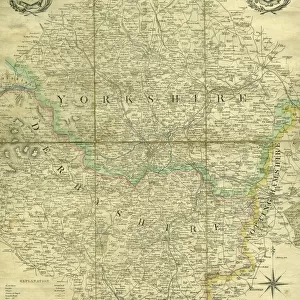
Framed Print > Europe > United Kingdom > England > Derbyshire > Brailsford
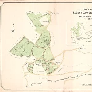
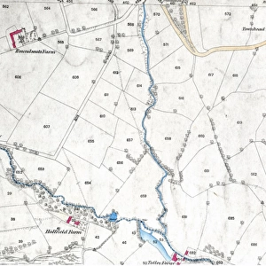
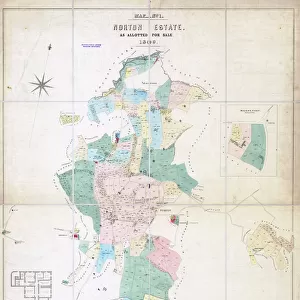
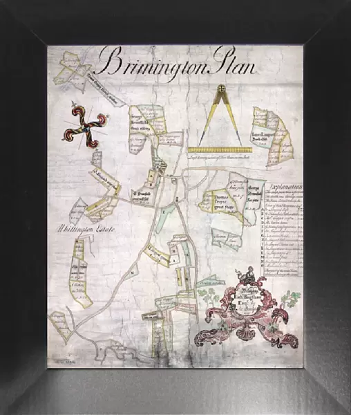
Framed Print : Plan of Brimington showing lands belonging to Richard Bagshaw, esquire


![]()
Framed Photos from Sheffield City Archives
Plan of Brimington showing lands belonging to Richard Bagshaw, esquire
By Samuel Brailsford.
Scale: 1 inch to 5 chains.
Field names, acreages and some tenants names given on the map; others in a schedule.
Title in a cartouche of shell patterns.
Original at Sheffield City Archives: arc01827
Sheffield City Archives and Local Studies Library has an unrivalled collection of images of Sheffield, England
Media ID 14046186
© Sheffield City Council
12"x10" Modern Frame
Step back in time with our exquisite Framed Print from Media Storehouse's historical collection. This stunning reproduction showcases an 18th-century map of Brimington, Sheffield, titled "Plan of Brimington showing lands belonging to Richard Bagshaw, esquire." The intricately detailed map, created by Samuel Brailsford, offers a fascinating glimpse into the past, featuring field names, acreages, and some tenant names. The map's decorative cartouche is adorned with beautiful shell patterns, adding an elegant touch to this captivating piece. Bring history into your home and transport yourself back in time with this unique and captivating framed print.
10x8 Print in an MDF Wooden Frame with 180 gsm Satin Finish Paper. Glazed using shatter proof thin plexi glass. Frame thickness is 1 inch and depth 0.75 inch. Fluted cardboard backing held with clips. Supplied ready to hang with sawtooth hanger and rubber bumpers. Spot clean with a damp cloth. Packaged foam wrapped in a card.
Contemporary Framed and Mounted Prints - Professionally Made and Ready to Hang
Estimated Image Size (if not cropped) is 25.4cm x 25.4cm (10" x 10")
Estimated Product Size is 25.4cm x 30.5cm (10" x 12")
These are individually made so all sizes are approximate
Artwork printed orientated as per the preview above, with landscape (horizontal) or portrait (vertical) orientation to match the source image.
FEATURES IN THESE COLLECTIONS
> Europe
> United Kingdom
> England
> Derbyshire
> Brailsford
> Europe
> United Kingdom
> England
> Derbyshire
> Related Images
> Maps and Charts
> Related Images
> Sheffield City Archives
> Maps and Plans
> Maps of Derbyshire
EDITORS COMMENTS
This print from Sheffield City Archives showcases a remarkable historical artifact: the "Plan of Brimington showing lands belonging to Richard Bagshaw, esquire". Created by Samuel Brailsford, this meticulously detailed map offers a fascinating glimpse into the past. The scale of 1 inch to 5 chains allows for precise measurements and accurate representation of the area. The map not only presents an overview of Brimington but also provides valuable information about its lands. Field names, acreages, and even some tenants' names are thoughtfully included on the map itself. For additional details, a schedule accompanies the plan with further insights into these properties. One cannot help but appreciate the artistic touch given to this document; its title is elegantly displayed within a cartouche adorned with intricate shell patterns. This attention to detail adds an aesthetic appeal that complements the informative nature of the map. Preserved at Sheffield City Archives under reference arc01827, this print serves as a testament to our rich heritage and serves as an invaluable resource for historians and enthusiasts alike. It offers us a unique opportunity to explore Brimington's history through its land ownerships during Richard Bagshaw's era
MADE IN THE USA
Safe Shipping with 30 Day Money Back Guarantee
FREE PERSONALISATION*
We are proud to offer a range of customisation features including Personalised Captions, Color Filters and Picture Zoom Tools
SECURE PAYMENTS
We happily accept a wide range of payment options so you can pay for the things you need in the way that is most convenient for you
* Options may vary by product and licensing agreement. Zoomed Pictures can be adjusted in the Cart.