Framed Print > Universal Images Group (UIG) > Art > Archeology
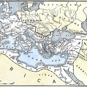
Framed Print : Ancient Rome, map of Roman Empire, illustration


![]()
Framed Photos From Universal Images Group (UIG)
Ancient Rome, map of Roman Empire, illustration
Cartography - Ancient Rome, map of Roman Empire during the 3rd century, illustration
Universal Images Group (UIG) manages distribution for many leading specialist agencies worldwide
Media ID 9469977
3rd Century Ancient Art Dividing Empire Mediterranean Sea Roman
18"x14" Modern Frame
Step back in time with our stunning Framed Prints from Media Storehouse, featuring an intricately detailed illustration of the Roman Empire during the 3rd century. This captivating map, sourced from Universal Images Group, offers a glimpse into the rich history of Ancient Rome. With expert craftsmanship and high-quality materials, our Framed Prints bring history to life in your home or office. Perfect for history enthusiasts, educators, or anyone seeking to add an element of timeless beauty to their space. Experience the grandeur and majesty of Ancient Rome with every glance. Order now and let history inspire you.
16x12 Print in an MDF Wooden Frame with 180 gsm Satin Finish Paper. Glazed using shatter proof thin plexiglass. Frame thickness is 1 inch and depth 0.75 inch. Fluted cardboard backing held with clips. Supplied ready to hang with sawtooth hanger and rubber bumpers. Spot clean with a damp cloth. Packaged foam wrapped in a card.
Contemporary Framed and Mounted Prints - Professionally Made and Ready to Hang
Estimated Image Size (if not cropped) is 40.6cm x 35.6cm (16" x 14")
Estimated Product Size is 45.7cm x 35.6cm (18" x 14")
These are individually made so all sizes are approximate
Artwork printed orientated as per the preview above, with landscape (horizontal) orientation to match the source image.
EDITORS COMMENTS
This print showcases a meticulously detailed map of the Roman Empire during its glorious 3rd century. A true testament to the ancient civilization's vast reach and power, this illustration takes us on a journey through time, immersing us in the rich history and geography of Ancient Rome. The empire's boundaries are clearly defined, stretching from Britannia in the northwest to Mesopotamia in the east, while encompassing diverse regions such as Gaul, Hispania, Africa Proconsularis, and Egypt along the way. The horizontal composition allows for an immersive experience as we trace our fingers across this antique masterpiece. The Mediterranean Sea acts as a central divide between Europe and Africa, serving as both a strategic advantage for trade routes and an emblematic symbol of Rome's dominance over these lands. As we gaze upon this ancient art form brought to life through cartography and illustration techniques, it is impossible not to be transported back in time. This print serves as a window into the past - an opportunity to explore one of history's greatest empires with awe-inspiring detail. With no people present within this image, our focus is solely on appreciating the craftsmanship behind this historical artifact. Whether displayed within educational institutions or personal collections dedicated to preserving human heritage, this remarkable piece offers endless opportunities for exploration and appreciation of Ancient Rome's legacy.
MADE IN THE USA
Safe Shipping with 30 Day Money Back Guarantee
FREE PERSONALISATION*
We are proud to offer a range of customisation features including Personalised Captions, Color Filters and Picture Zoom Tools
SECURE PAYMENTS
We happily accept a wide range of payment options so you can pay for the things you need in the way that is most convenient for you
* Options may vary by product and licensing agreement. Zoomed Pictures can be adjusted in the Basket.