Framed Print > Europe > United Kingdom > England > Sussex > Rackham
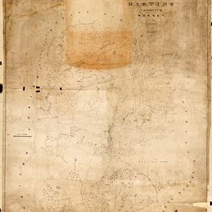
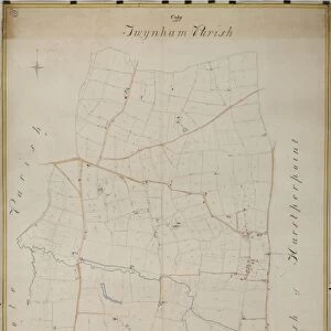
Framed Print : Amberley Tithe Map, 1847


![]()
Framed Photos from West Sussex County Council
Amberley Tithe Map, 1847
By Joseph Butler, Surveyor, Chichester. 17.6 in. to 1 m. Original map size 47in. × 42in. Includes hamlet of Rackham
Tithe Award Map Collection
West Sussex Record Office Ref: TD/W2
West Sussex County Council Record Office contains a fascinating history of the county of West Sussex, England
Media ID 7914389
© West Sussex County Council - All Rights Reserved
12"x10" Modern Frame
Discover the history of West Sussex with our stunning Framed Prints from Media Storehouse. This captivating piece showcases the Amberley Tithe Map of 1847, meticulously surveyed by Joseph Butler in Chichester. Originally measuring over 4 feet by 3.5 feet, this intricately detailed map from the West Sussex Record Office (Ref: TD/W2) now comes to you in a beautifully framed format. Bring a piece of historical West Sussex into your home and transport yourself back in time with this unique and authentic framed print.
10x8 Print in an MDF Wooden Frame with 180 gsm Satin Finish Paper. Glazed using shatter proof thin plexi glass. Frame thickness is 1 inch and depth 0.75 inch. Fluted cardboard backing held with clips. Supplied ready to hang with sawtooth hanger and rubber bumpers. Spot clean with a damp cloth. Packaged foam wrapped in a card.
Contemporary Framed and Mounted Prints - Professionally Made and Ready to Hang
Estimated Image Size (if not cropped) is 25.4cm x 25.4cm (10" x 10")
Estimated Product Size is 25.4cm x 30.5cm (10" x 12")
These are individually made so all sizes are approximate
Artwork printed orientated as per the preview above, with landscape (horizontal) or portrait (vertical) orientation to match the source image.
FEATURES IN THESE COLLECTIONS
> Europe
> United Kingdom
> England
> Sussex
> Amberley
> Europe
> United Kingdom
> England
> Sussex
> Chichester
> Europe
> United Kingdom
> England
> Sussex
> Rackham
> Europe
> United Kingdom
> England
> Sussex
> Related Images
> Europe
> United Kingdom
> England
> West Sussex
> Chichester
> Europe
> United Kingdom
> England
> West Sussex
> Related Images
> Maps and Charts
> Related Images
> West Sussex County Council
> West Sussex Record Office
> Tithe Award Maps, 1808-1859
EDITORS COMMENTS
This print showcases the historical Amberley Tithe Map from 1847, meticulously created by Joseph Butler, a renowned surveyor from Chichester. The map's scale is an impressive 17.6 inches to 1 meter, with its original size measuring a remarkable 47 inches by 42 inches. A notable feature of this map is that it includes the charming hamlet of Rackham, adding to its significance and appeal. Part of the esteemed Tithe Award Map Collection, this particular piece can be found in the West Sussex Record Office under reference TD/W2. It serves as a valuable resource for historians and researchers alike who are eager to explore the rich history and land ownership patterns within West Sussex County. The Amberley Tithe Map offers a glimpse into the past, providing insights into how land was divided and utilized during that era. Its intricate details and precise measurements make it an invaluable tool for studying rural landscapes and understanding their evolution over time
MADE IN THE USA
Safe Shipping with 30 Day Money Back Guarantee
FREE PERSONALISATION*
We are proud to offer a range of customisation features including Personalised Captions, Color Filters and Picture Zoom Tools
SECURE PAYMENTS
We happily accept a wide range of payment options so you can pay for the things you need in the way that is most convenient for you
* Options may vary by product and licensing agreement. Zoomed Pictures can be adjusted in the Cart.