
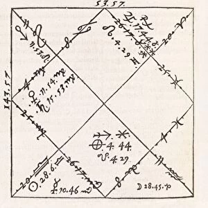
1570 Collection (page 9)

Step back in time to the year 1570, a period of exploration and cultural exchange

Background image1570 Collection: Cross section of the nave of the basilica, at El Escorial monastery in Spain

Cross section of the nave of the basilica, at El Escorial monastery in Spain
EL ESCORIAL: BASILICA. Cross section of the nave of the basilica, at El Escorial monastery in Spain. Drawing by architect Juan de Herrera, c1570

Background image1570 Collection: Rough sketch of the Altar of Reliquaries in the nave of the basilica at El Escorial monastery in

Rough sketch of the Altar of Reliquaries in the nave of the basilica at El Escorial monastery in Spain
EL ESCORIAL: ALTAR, c1570. Rough sketch of the Altar of Reliquaries in the nave of the basilica at El Escorial monastery in Spain. Drawing by architect Juan de Herrera, c1570

Background image1570 Collection: Posterior facade of the second Casa de Oficio, or Official Building

Posterior facade of the second Casa de Oficio, or Official Building, near El Escorial monastery in Spain
EL ESCORIAL: CASA DE OFICIO. Posterior facade of the second Casa de Oficio, or Official Building, near El Escorial monastery in Spain. Drawing by architect Juan de Herrera, c1570

Background image1570 Collection: Study of the door to the kitchen at El Escorial palace in Spain

Study of the door to the kitchen at El Escorial palace in Spain. Drawing by architect Juan de Herrera, c1570
EL ESCORIAL: DOOR, c1570. Study of the door to the kitchen at El Escorial palace in Spain. Drawing by architect Juan de Herrera, c1570

Background image1570 Collection: Plan for the water-powered mill at El Escorial monastery in Spain

Plan for the water-powered mill at El Escorial monastery in Spain. Drawing by architect Juan de Herrera, c1570
EL ESCORIAL: MILL, c1570. Plan for the water-powered mill at El Escorial monastery in Spain. Drawing by architect Juan de Herrera, c1570

Background image1570 Collection: Elevation plan of the second Casa de Oficio, or Official Building

Elevation plan of the second Casa de Oficio, or Official Building, near El Escorial monastery in Spain
EL ESCORIAL: ELEVATION. Elevation plan of the second Casa de Oficio, or Official Building, near El Escorial monastery in Spain

Background image1570 Collection: Philip II (May 21, 1527 - September 13, 1598) King of Spain from 1556 until 1598

Philip II (May 21, 1527 - September 13, 1598) King of Spain from 1556 until 1598. Index Librorum Prohibitorum. 1570. List of banned books published by the Spanish Inquisition

Background image1570 Collection: Map of the Kingdom of Naples, Italy, from Theatrum Orbis Terrarum by Abraham Ortelius, 1528-1598

Map of the Kingdom of Naples, Italy, from Theatrum Orbis Terrarum by Abraham Ortelius, 1528-1598, 1570
Cartography, Italy, 16th century. Map of the Kingdom of Naples, from Theatrum Orbis Terrarum by Abraham Ortelius (1528-1598), Antwerp, 1570

Background image1570 Collection: Map of Mediterranean Islands, from Theatrum Orbis Terrarum by Abraham Ortelius, 1528-1598, 1570

Map of Mediterranean Islands, from Theatrum Orbis Terrarum by Abraham Ortelius, 1528-1598, 1570
Cartography, 16th century. Map of Mediterranean Islands, from Theatrum Orbis Terrarum by Abraham Ortelius (1528-1598), Antwerp, 1570

Background image1570 Collection: Map of Bavaria, Germany, from Theatrum Orbis Terrarum by Abraham Ortelius, 1528-1598, 1570

Map of Bavaria, Germany, from Theatrum Orbis Terrarum by Abraham Ortelius, 1528-1598, 1570
Cartography, Germany, 16th century. Map of Bavaria, from Theatrum Orbis Terrarum by Abraham Ortelius (1528-1598), Antwerp, 1570

Background image1570 Collection: Map of Switzerland, from Theatrum Orbis Terrarum by Abraham Ortelius, 1528-1598, 1570

Map of Switzerland, from Theatrum Orbis Terrarum by Abraham Ortelius, 1528-1598, 1570
Cartography, 16th century. Map of Switzerland, from Theatrum Orbis Terrarum by Abraham Ortelius (1528-1598), Antwerp, 1570

Background image1570 Collection: Map of Northern Africa, from Theatrum Orbis Terrarum by Abraham Ortelius, 1528-1598, 1570

Map of Northern Africa, from Theatrum Orbis Terrarum by Abraham Ortelius, 1528-1598, 1570
Cartography, 16th century. Map of Northern Africa, from Theatrum Orbis Terrarum by Abraham Ortelius (1528-1598), Antwerp, 1570

Background image1570 Collection: Map of Greece, from Theatrum Orbis Terrarum by Abraham Ortelius, 1528-1598, 1570

Map of Greece, from Theatrum Orbis Terrarum by Abraham Ortelius, 1528-1598, 1570
Cartography, 16th century. Map of Greece, from Theatrum Orbis Terrarum by Abraham Ortelius (1528-1598), Antwerp, 1570

Background image1570 Collection: Map of Russia, from Theatrum Orbis Terrarum by Abraham Ortelius, 1528-1598, 1570

Map of Russia, from Theatrum Orbis Terrarum by Abraham Ortelius, 1528-1598, 1570
Cartography, 16th century. Map of Russia, from Theatrum Orbis Terrarum by Abraham Ortelius (1528-1598), Antwerp, 1570

Background image1570 Collection: Map of the Indies, from Theatrum Orbis Terrarum by Abraham Ortelius, 1528-1598, 1570

Map of the Indies, from Theatrum Orbis Terrarum by Abraham Ortelius, 1528-1598, 1570
Cartography, 16th century. Map of the Indies, from Theatrum Orbis Terrarum by Abraham Ortelius (1528-1598), Antwerp, 1570

Background image1570 Collection: Map of the Region of Piedmont, Italy, from Theatrum Orbis Terrarum by Abraham Ortelius, 1528-1598

Map of the Region of Piedmont, Italy, from Theatrum Orbis Terrarum by Abraham Ortelius, 1528-1598, 1570
Cartography, Italy, 16th century. Map of the Region of Piedmont, from Theatrum Orbis Terrarum by Abraham Ortelius (1528-1598), Antwerp, 1570

Background image1570 Collection: Map of Northern Europe, from Theatrum Orbis Terrarum by Abraham Ortelius, 1528-1598, 1570

Map of Northern Europe, from Theatrum Orbis Terrarum by Abraham Ortelius, 1528-1598, 1570
Cartography, 16th century. Map of Northern Europe, from Theatrum Orbis Terrarum by Abraham Ortelius (1528-1598), Antwerp, 1570

Background image1570 Collection: Map of Salzburg diocese, Austria, from Theatrum Orbis Terrarum by Abraham Ortelius, 1528-1598, 1570

Map of Salzburg diocese, Austria, from Theatrum Orbis Terrarum by Abraham Ortelius, 1528-1598, 1570
Cartography, Austria, 16th century. Map of Salzburg diocese, from Theatrum Orbis Terrarum by Abraham Ortelius (1528-1598), Antwerp, 1570

Background image1570 Collection: Map of Turkey, from Theatrum Orbis Terrarum by Abraham Ortelius, 1528-1598, 1570

Map of Turkey, from Theatrum Orbis Terrarum by Abraham Ortelius, 1528-1598, 1570
Cartography, 16th century. Map of Turkey. From Theatrum Orbis Terrarum by Abraham Ortelius (1528-1598), Antwerp, 1570

Background image1570 Collection: Map of Italy from Theatrum Orbis Terrarum, by Abraham Ortelius, 1528-1598, engraving, 1570

Map of Italy from Theatrum Orbis Terrarum, by Abraham Ortelius, 1528-1598, engraving, 1570
Cartography, Italy, 16th century. Map of Italy, by Abraham Ortelius (1528-1598), from Theatrum Orbis Terrarum, 1570

Background image1570 Collection: Map of Tuscia from Theatrum Orbis Terrarum by Abraham Ortelius, 1528-1598, 1570

Map of Tuscia from Theatrum Orbis Terrarum by Abraham Ortelius, 1528-1598, 1570
Cartography, Italy, 16th century. Map of Tuscia (Region of Lazio). From Theatrum Orbis Terrarum by Abraham Ortelius (1528-1598), 1570

Background image1570 Collection: Map of the Duchy of Milan, Italy, from Theatrum Orbis Terrarum by Abraham Ortelius, 1528-1598, 1570

Map of the Duchy of Milan, Italy, from Theatrum Orbis Terrarum by Abraham Ortelius, 1528-1598, 1570
Cartography, Italy, 16th century. Map of the Duchy of Milan, from Theatrum Orbis Terrarum by Abraham Ortelius (1528-1598), Antwerp, 1570

Background image1570 Collection: Euclids Elements of Geometry

Euclids Elements of Geometry. Frontispiece of Euclids Elements of Geometry. This edition was printed in London in 1570 and has a preface by the Welsh mathematician John Dee (1527-1609)

Background image1570 Collection: Horses hoof, 16th century

Horses hoof, 16th century
Horses hoof, 16th-century artwork. This woodcut is from the 1583 edition of Libro de enfrentamientos de la gineta, originally published in Toledo in 1570 by the Spanish author Eugenio Manzanas

Background image1570 Collection: JAUREGUI, Juan de (1570-1641)

JAUREGUI, Juan de (1570-1641). D. Painting

Background image1570 Collection: SCHOUBROECK, Pieter (1570-1607)

SCHOUBROECK, Pieter (1570-1607). The Burning of Troy (Der Brand Trojas). Oil on copper. Oil on wood

Background image1570 Collection: Mary Countess Buckingham

Mary Countess Buckingham
MARY BEAUMONT, countess of BUCKINGHAM, second wife of Sir George Villiers, mother of George first duke of Buckingham. Date: 1570 - 1632

Background image1570 Collection: A hermit sitting on a stylite. Indian mughal miniature painting from the Hamzanama, c1570

A hermit sitting on a stylite. Indian mughal miniature painting from the Hamzanama, c1570
HAMZANAMA, c1570. A hermit sitting on a stylite. Indian mughal miniature painting from the Hamzanama, c1570

Background image1570 Collection: ELEPHANT, c1570. Line engraving from Konrad Gesners Historia animalium... Zurich, 1551-1587

ELEPHANT, c1570. Line engraving from Konrad Gesners Historia animalium... Zurich, 1551-1587

Background image1570 Collection: FIVE NATIONS: MEETING, c1570. Iroquois leaders from the Five Nations (Cayuga, Mohawk, Oneida)

FIVE NATIONS: MEETING, c1570. Iroquois leaders from the Five Nations (Cayuga, Mohawk, Oneida, Onondaga)
FIVE NATIONS: MEETING, c1570. Iroquois leaders from the Five Nations (Cayuga, Mohawk, Oneida, Onondaga, and Seneca) assembled around the Huron prophet Deganawidah, center

Background image1570 Collection: Elizabethan Gatehouse

Elizabethan Gatehouse
The beautiful black and white gatehouse of Stokesay Castle, Shropshire, England, dates from circa 1570, and was probably more for ornamental than defemsive purposes. Date: late 16th century

Background image1570 Collection: Johannes Brenz, Church

Johannes Brenz, Church
JOHANNES BRENZ (Brentius) German Lutheran churchman. Date: 1498 - 1570

Background image1570 Collection: Fencing with daggers

Fencing with daggers
A group of men engage in combat with one another, using daggers to fence with. Date: 1570

Background image1570 Collection: GERMAN NOBLES 1570-88

GERMAN NOBLES 1570-88
Two German noblemen wear small ruffs, doublets, cut-fingered pumps, hose or breeches ornamented with embroidery or ribbon bows, a sleeveless jerkin & short cloak. Date: 1570 - 1588

Background image1570 Collection: Viola Da Gamba C16

Viola Da Gamba C16
Viola da Gamba made by Gaspar Duiffoprugear (1514-1570), a renowned Tyrolese instrument maker. Date: circa 1550

Background image1570 Collection: DIANE DE POITIERS (1499-1566). Mistress of Henry II of France

DIANE DE POITIERS (1499-1566). Mistress of Henry II of France. Diane de Poitiers as an Allegory of Peace. Oil on panel, c1568-70, by Jean Capassin

Background image1570 Collection: NEW WORLD MAP, 1570. A New Description of America, or the New World

NEW WORLD MAP, 1570. A New Description of America, or the New World. Map from Abraham Ortelius Theatrum Orbis Terrarum, 1570

Background image1570 Collection: Astrology chart, 16th century

Astrology chart, 16th century
Astrology chart. 16th-century astrological chart of Edward VI of England (1537-1553). Edward was King of England from the age of nine until his death aged fifteen from a severe lung disease

Background image1570 Collection: Orteliuss map of Denmark, 1570

Orteliuss map of Denmark, 1570
Orteliuss map of Denmark. This map is from the 1570 first edition of Theatrum orbis terrarum ( Theatre of the World ). Drawn by the Flemish mapmaker Abraham Ortelius (1527-1598)

Background image1570 Collection: Orteliuss map of European Russia, 1570

Orteliuss map of European Russia, 1570
Orteliuss map of European Russia. This map is from the 1570 first edition of Theatrum orbis terrarum ( Theatre of the World )

Background image1570 Collection: Orteliuss map of Europe, 1570

Orteliuss map of Europe, 1570. This map is from the 1570 first edition of Theatrum orbis terrarum ( Theatre of the World )

Background image1570 Collection: Orteliuss map of Asia, 1570

Orteliuss map of Asia, 1570
Orteliuss map of Asia. This map is from the 1570 first edition of Theatrum orbis terrarum ( Theatre of the World ). Drawn by the Flemish mapmaker Abraham Ortelius (1527-1598)

Background image1570 Collection: Orteliuss map of France, 1570

Orteliuss map of France, 1570
Orteliuss map of France. This map is from the 1570 first edition of Theatrum orbis terrarum ( Theatre of the World ). Drawn by the Flemish mapmaker Abraham Ortelius (1527-1598)

Background image1570 Collection: Orteliuss map of Austria, 1570

Orteliuss map of Austria, 1570
Orteliuss map of Austria. This map is from the 1570 first edition of Theatrum orbis terrarum ( Theatre of the World ). Drawn by the Flemish mapmaker Abraham Ortelius (1527-1598)

Background image1570 Collection: Orteliuss map of Switzerland, 1570

Orteliuss map of Switzerland, 1570
Orteliuss map of Switzerland. This map is from the 1570 first edition of Theatrum orbis terrarum ( Theatre of the World )

Background image1570 Collection: Orteliuss map of Northern Europe, 1570

Orteliuss map of Northern Europe, 1570
Orteliuss map of Northern Europe. This map is from the 1570 first edition of Theatrum orbis terrarum ( Theatre of the World )

Background image1570 Collection: Orteliuss map of Bohemia, 1570

Orteliuss map of Bohemia, 1570
Orteliuss map of Bohemia. This map is from the 1570 first edition of Theatrum orbis terrarum ( Theatre of the World ). Drawn by the Flemish mapmaker Abraham Ortelius (1527-1598)

Background image1570 Collection: Orteliuss map of Iberian Peninsula, 1570

Orteliuss map of Iberian Peninsula, 1570
Orteliuss map of Iberian Peninsula. This map is from the 1570 first edition of Theatrum orbis terrarum ( Theatre of the World )


For sale as Licensed Images

Choose your image, Select your licence and Download the media

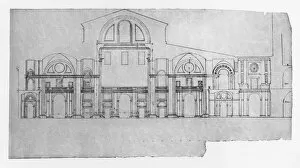
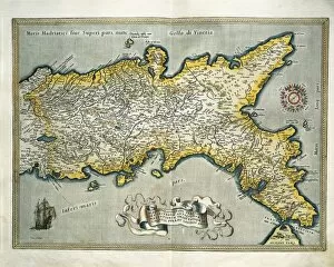
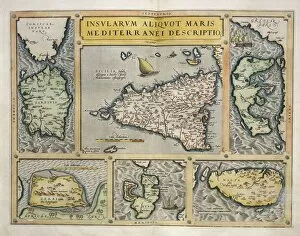
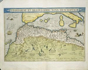
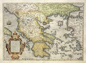
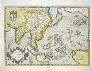
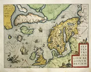
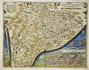
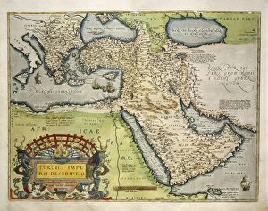
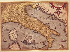
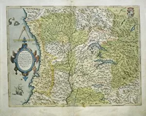
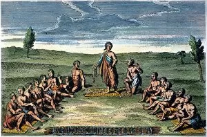
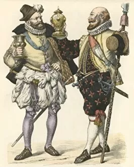
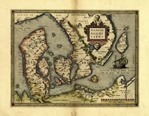
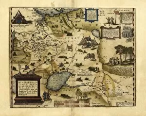
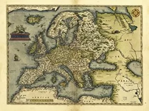
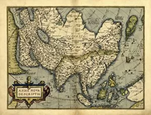
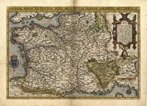
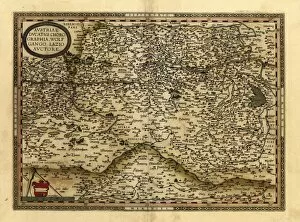
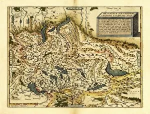
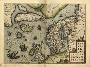
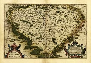
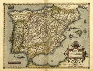
Step back in time to the year 1570, a period of exploration and cultural exchange. Orteliuss map of the Ottoman Empire reveals the vastness and complexity of this powerful empire that stretched across three continents. Meanwhile, a 16th-century map of the British Isles showcases the evolving political landscape during this era. Intriguingly, a Venetian Galley from 1570 sails through turbulent waters, symbolizing both trade and conflict in the Mediterranean region. The presence of Nubians in Ancient Egypt reminds us of Africa's rich history intertwined with ancient civilizations. Orteliuss meticulous cartography also captures Italy's diverse regions, Poland's shifting borders, and Greece's storied past. His magnum opus, Theatrum Orbis Terrarum (Theatre of the World), presents an awe-inspiring world view that expands our horizons beyond imagination. Amidst these historical snapshots emerges an unexpected scene: Fencing with pikes in 1570. This martial art was not only practiced for self-defense but also as a form of entertainment. Target practice honed warriors' skills while ensuring their readiness for battle. Finally, Orteliuss map transports us to his homeland - Holland - where he meticulously charts its cities and waterways. These maps serve as windows into a bygone era when explorers dared to venture into uncharted territories.