Home > Maps and Charts > Abraham Ortelius
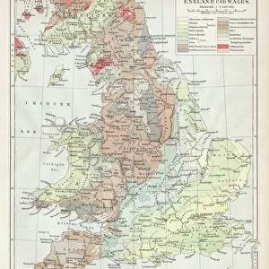
Orteliuss map of Bohemia, 1570

![]()
Wall Art and Photo Gifts from Science Photo Library
Orteliuss map of Bohemia, 1570
Orteliuss map of Bohemia. This map is from the 1570 first edition of Theatrum orbis terrarum ( Theatre of the World ). Drawn by the Flemish mapmaker Abraham Ortelius (1527-1598), and published by Gilles Coppens de Diest in Antwerp, this collection of 53 maps is considered to be the first true modern atlas
Science Photo Library features Science and Medical images including photos and illustrations
Media ID 6297843
© LIBRARY OF CONGRESS, GEOGRAPHY AND MAP DIVISION/SCIENCE PHOTO LIBRARY
1500s 1570 1570 Edition 16th Century Abraham Ortelius Age Of Discovery Antwerp Edition Cartographic Cartography Country Czech Czech Republic Dutch First Edition First Modern Atlas Flemish Gilles Coppens De Diest Latin Latin Edition Nation Orteliuss Text Theatre Of The World Theatrum Orbis Terrarum Writing Bohemia Bohemian Slav Slavic
EDITORS COMMENTS
This print showcases Orteliuss map of Bohemia, a remarkable piece of art and historical documentation. Created in 1570 by the Flemish mapmaker Abraham Ortelius, this map is part of the first edition of Theatrum orbis terrarum (Theatre of the World), published by Gilles Coppens de Diest in Antwerp. Comprising a collection of 53 maps, this work is widely regarded as the first true modern atlas. It provides an intricate depiction of Bohemia during the 16th century, offering valuable insights into European geography and history. The detailed illustration captures the essence of this Slavic nation with its Latin text accompanying various geographical features. Orteliuss cartographic masterpiece represents a significant contribution to the Age of Discovery and serves as a testament to his expertise in mapping techniques. This particular edition holds immense historical value as it sheds light on Europe's evolving political landscape during that time. Through this photo print, we are transported back to an era where cartography was both an art form and a scientific endeavor. It allows us to appreciate not only Ortelius's skillful craftsmanship but also his dedication to accurately representing different regions across Europe. Overall, this image offers viewers a glimpse into Bohemias past while celebrating Ortelius's pioneering efforts in creating one of the world's most influential atlases – truly deserving its place among esteemed works from that period.
MADE IN THE USA
Safe Shipping with 30 Day Money Back Guarantee
FREE PERSONALISATION*
We are proud to offer a range of customisation features including Personalised Captions, Color Filters and Picture Zoom Tools
SECURE PAYMENTS
We happily accept a wide range of payment options so you can pay for the things you need in the way that is most convenient for you
* Options may vary by product and licensing agreement. Zoomed Pictures can be adjusted in the Cart.