
The Limes Collection
"The Limes: A Journey Through Time and Space" Step into a world where history intertwines with modernity

For sale as Licensed Images
Choose your image, Select your licence and Download the media
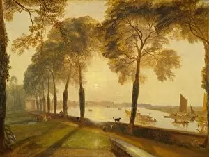
"The Limes: A Journey Through Time and Space" Step into a world where history intertwines with modernity, as we embark on a captivating journey through various locations across the United Kingdom. From the quaint town of Wigan in Staffordshire to the picturesque landscapes of Plymouth, Bedford, Harborough, Leeds, East Riding of Yorkshire, Colchester, Wolverhampton, and North Yorkshire - each destination holds its own unique charm. Starting our adventure at The Limes in Wigan (WA3 1 Map), we are greeted by an enchanting blend of old-world architecture and contemporary living. As we move further south to Staffordshire (ST5 8 Map), the map unfolds before us like a treasure trove waiting to be discovered. Our next stop takes us to Plymouth (PL6 5 Map), where coastal beauty meets urban vibrancy. Here, ancient tales whisper through every street corner while modern life pulsates around us. Continuing eastward towards Bedford (MK45 2 Map), we find ourselves immersed in a tapestry of historical significance that stretches back centuries. Leaving Bedford behind, our path leads us to Harborough (LE16 7 Map) - a hidden gem nestled amidst rolling hills and charming villages. It's here that time seems to slow down as we soak up the tranquility surrounding us. As our expedition carries on northwards towards Leeds (LS25 5 Map), East Riding of Yorkshire (HU15 2 Map), and Colchester (CO7 7 Map), we witness how these vibrant cities seamlessly blend their rich heritage with bustling city life. Each step reveals layers upon layers of stories waiting to be unraveled. Venturing westward brings us to Mortlake Terrace in London - immortalized by JMW Turner's brushstrokes in his iconic painting from 1827. This masterpiece captures both the essence of timelessness and fleeting moments within one frame.