
Theatrum Orbis Terrarum Collection (#2)

"Theatrum Orbis Terrarum

Background imageTheatrum Orbis Terrarum Collection: Map of Palestine, from Theatrvm Orbis Terrarvm, 1570 (hand coloured engraving)

Map of Palestine, from Theatrvm Orbis Terrarvm, 1570 (hand coloured engraving)
XCF324389 Map of Palestine, from Theatrvm Orbis Terrarvm, 1570 (hand coloured engraving) by Ortelius, Abraham (1527-98); Private Collection; (add.info)

Background imageTheatrum Orbis Terrarum Collection: Map of the Kingdom of Naples, Italy, from Theatrum Orbis Terrarum by Abraham Ortelius, 1528-1598

Map of the Kingdom of Naples, Italy, from Theatrum Orbis Terrarum by Abraham Ortelius, 1528-1598, 1570
Cartography, Italy, 16th century. Map of the Kingdom of Naples, from Theatrum Orbis Terrarum by Abraham Ortelius (1528-1598), Antwerp, 1570

Background imageTheatrum Orbis Terrarum Collection: Map of Mediterranean Islands, from Theatrum Orbis Terrarum by Abraham Ortelius, 1528-1598, 1570

Map of Mediterranean Islands, from Theatrum Orbis Terrarum by Abraham Ortelius, 1528-1598, 1570
Cartography, 16th century. Map of Mediterranean Islands, from Theatrum Orbis Terrarum by Abraham Ortelius (1528-1598), Antwerp, 1570

Background imageTheatrum Orbis Terrarum Collection: Map of Bavaria, Germany, from Theatrum Orbis Terrarum by Abraham Ortelius, 1528-1598, 1570

Map of Bavaria, Germany, from Theatrum Orbis Terrarum by Abraham Ortelius, 1528-1598, 1570
Cartography, Germany, 16th century. Map of Bavaria, from Theatrum Orbis Terrarum by Abraham Ortelius (1528-1598), Antwerp, 1570

Background imageTheatrum Orbis Terrarum Collection: Map of Switzerland, from Theatrum Orbis Terrarum by Abraham Ortelius, 1528-1598, 1570

Map of Switzerland, from Theatrum Orbis Terrarum by Abraham Ortelius, 1528-1598, 1570
Cartography, 16th century. Map of Switzerland, from Theatrum Orbis Terrarum by Abraham Ortelius (1528-1598), Antwerp, 1570

Background imageTheatrum Orbis Terrarum Collection: Planisphere from Theatrum Orbis Terrarum by Abraham Ortelius, printed in Antwerp, 1570

Planisphere from Theatrum Orbis Terrarum by Abraham Ortelius, printed in Antwerp, 1570
Cartography, 16th century. Planisphere, from Theatrum Orbis Terrarum by Abraham Ortelius (1528-1598), Antwerp, 1570

Background imageTheatrum Orbis Terrarum Collection: Map of Northern Africa, from Theatrum Orbis Terrarum by Abraham Ortelius, 1528-1598, 1570

Map of Northern Africa, from Theatrum Orbis Terrarum by Abraham Ortelius, 1528-1598, 1570
Cartography, 16th century. Map of Northern Africa, from Theatrum Orbis Terrarum by Abraham Ortelius (1528-1598), Antwerp, 1570

Background imageTheatrum Orbis Terrarum Collection: Map of Italy by Abraham Ortelius, 1528-1598, from Theatrum Orbis Terrarum, 1570

Map of Italy by Abraham Ortelius, 1528-1598, from Theatrum Orbis Terrarum, 1570
Cartography, Italy, 16th century. Map of Italy by Abraham Ortelius (1528-1598), from Theatrum Orbis Terrarum, 1570

Background imageTheatrum Orbis Terrarum Collection: Brabant from Theatrum Orbis Terrarum by Willem Bleau, Amsterdam, 1635-1645

Brabant from Theatrum Orbis Terrarum by Willem Bleau, Amsterdam, 1635-1645
Cartography, Netherlands, 17th century. Brabant. From Theatrum Orbis Terrarum by Willem Bleau, Amsterdam. 1635-1645

Background imageTheatrum Orbis Terrarum Collection: Great Britian and Ireland from Theatrum Orbis Terrarum by Willem Bleau, Amsterdam, 1635-1645

Great Britian and Ireland from Theatrum Orbis Terrarum by Willem Bleau, Amsterdam, 1635-1645
Cartography, 17th century. Great Britian and Ireland. From Theatrum Orbis Terrarum by Willem Bleau, Amsterdam. 1635-1645

Background imageTheatrum Orbis Terrarum Collection: Port of Palos in Andalusia, from Theatrum Orbis Terrarum by Abraham Ortelius, 1570

Port of Palos in Andalusia, from Theatrum Orbis Terrarum by Abraham Ortelius, 1570
Cartography, 16th century. The port of Palos in Andalusia. From Theatrum Orbis Terrarum by Abraham Ortelius (1528-1598), Antwerp, 1570

Background imageTheatrum Orbis Terrarum Collection: Map of Greece, from Theatrum Orbis Terrarum by Abraham Ortelius, 1528-1598, 1570

Map of Greece, from Theatrum Orbis Terrarum by Abraham Ortelius, 1528-1598, 1570
Cartography, 16th century. Map of Greece, from Theatrum Orbis Terrarum by Abraham Ortelius (1528-1598), Antwerp, 1570

Background imageTheatrum Orbis Terrarum Collection: Map of Russia, from Theatrum Orbis Terrarum by Abraham Ortelius, 1528-1598, 1570

Map of Russia, from Theatrum Orbis Terrarum by Abraham Ortelius, 1528-1598, 1570
Cartography, 16th century. Map of Russia, from Theatrum Orbis Terrarum by Abraham Ortelius (1528-1598), Antwerp, 1570

Background imageTheatrum Orbis Terrarum Collection: Holland from Theatrum Orbis Terrarum by Willem Bleau, Amsterdam, 1635-1645

Holland from Theatrum Orbis Terrarum by Willem Bleau, Amsterdam, 1635-1645
Cartography, Netherlands, 17th century. Holland. From Theatrum Orbis Terrarum by Willem Bleau, Amsterdam. 1635-1645

Background imageTheatrum Orbis Terrarum Collection: Map of the Indies, from Theatrum Orbis Terrarum by Abraham Ortelius, 1528-1598, 1570

Map of the Indies, from Theatrum Orbis Terrarum by Abraham Ortelius, 1528-1598, 1570
Cartography, 16th century. Map of the Indies, from Theatrum Orbis Terrarum by Abraham Ortelius (1528-1598), Antwerp, 1570

Background imageTheatrum Orbis Terrarum Collection: Map of coast of Virginia, from Theatrum Orbis Terrarum by Joan Blaeu, 1596-1673

Map of coast of Virginia, from Theatrum Orbis Terrarum by Joan Blaeu, 1596-1673
Cartography, America, 17th century. Map of coast of Virginia, from Theatrum Orbis Terrarum by Joan Blaeu (1596-1673)

Background imageTheatrum Orbis Terrarum Collection: Map of the Region of Piedmont, Italy, from Theatrum Orbis Terrarum by Abraham Ortelius, 1528-1598

Map of the Region of Piedmont, Italy, from Theatrum Orbis Terrarum by Abraham Ortelius, 1528-1598, 1570
Cartography, Italy, 16th century. Map of the Region of Piedmont, from Theatrum Orbis Terrarum by Abraham Ortelius (1528-1598), Antwerp, 1570

Background imageTheatrum Orbis Terrarum Collection: Map of Northern Europe, from Theatrum Orbis Terrarum by Abraham Ortelius, 1528-1598, 1570

Map of Northern Europe, from Theatrum Orbis Terrarum by Abraham Ortelius, 1528-1598, 1570
Cartography, 16th century. Map of Northern Europe, from Theatrum Orbis Terrarum by Abraham Ortelius (1528-1598), Antwerp, 1570

Background imageTheatrum Orbis Terrarum Collection: Veteris Germany from Theatrum Orbis Terrarum by Willem Bleau, Amsterdam, 1635-1645

Veteris Germany from Theatrum Orbis Terrarum by Willem Bleau, Amsterdam, 1635-1645
Cartography, Germany, 17th century. Veteris Germany. From Theatrum Orbis Terrarum by Willem Bleau, Amsterdam. 1635-1645

Background imageTheatrum Orbis Terrarum Collection: Map of Italy, from Theatrum Orbis Terrarum by Willem Blaeu, Amsterdam, 1635-1645

Map of Italy, from Theatrum Orbis Terrarum by Willem Blaeu, Amsterdam, 1635-1645
Cartography, Germany, 17th century. Map of Italy, from Theatrum Orbis Terrarum by Willem Blaeu, Amsterdam, 1635-1645

Background imageTheatrum Orbis Terrarum Collection: Map of Salzburg diocese, Austria, from Theatrum Orbis Terrarum by Abraham Ortelius, 1528-1598, 1570

Map of Salzburg diocese, Austria, from Theatrum Orbis Terrarum by Abraham Ortelius, 1528-1598, 1570
Cartography, Austria, 16th century. Map of Salzburg diocese, from Theatrum Orbis Terrarum by Abraham Ortelius (1528-1598), Antwerp, 1570

Background imageTheatrum Orbis Terrarum Collection: Map of Turkey, from Theatrum Orbis Terrarum by Abraham Ortelius, 1528-1598, 1570

Map of Turkey, from Theatrum Orbis Terrarum by Abraham Ortelius, 1528-1598, 1570
Cartography, 16th century. Map of Turkey. From Theatrum Orbis Terrarum by Abraham Ortelius (1528-1598), Antwerp, 1570

Background imageTheatrum Orbis Terrarum Collection: Map of Island of Hispaniola, Santo Domingo, Puerto Rico and part of Antilles from Abraham

Map of Island of Hispaniola, Santo Domingo, Puerto Rico and part of Antilles from Abraham Ortelius, 1528-1598
Cartography, 16th century. Map of the Island of Hispaniola (Santo Domingo), Puerto Rico and part of the Antilles. From Abraham Ortelius (1528-1598), Theatrum Orbis Terrarum, 1570

Background imageTheatrum Orbis Terrarum Collection: Spain from Theatrum Orbis Terrarum by Willem Bleau, Amsterdam, 1635-1645

Spain from Theatrum Orbis Terrarum by Willem Bleau, Amsterdam, 1635-1645
Cartography, 17th century. Spain. From Theatrum Orbis Terrarum by Willem Bleau, Amsterdam. 1635-1645

Background imageTheatrum Orbis Terrarum Collection: Map of the Duchy of Milan, Italy, from Theatrum Orbis Terrarum by Abraham Ortelius, 1528-1598, 1570

Map of the Duchy of Milan, Italy, from Theatrum Orbis Terrarum by Abraham Ortelius, 1528-1598, 1570
Cartography, Italy, 16th century. Map of the Duchy of Milan, from Theatrum Orbis Terrarum by Abraham Ortelius (1528-1598), Antwerp, 1570

Background imageTheatrum Orbis Terrarum Collection: Ile-de-France, Isle of France from Theatrum Orbis Terrarum by Willem Bleau, Amsterdam, 1635-1645

Ile-de-France, Isle of France from Theatrum Orbis Terrarum by Willem Bleau, Amsterdam, 1635-1645
Cartography, France, 17th century. AZle-de-France (Isle of France). From Theatrum Orbis Terrarum by Willem Bleau, Amsterdam. 1635-1645

Background imageTheatrum Orbis Terrarum Collection: Hodierna Germany from Theatrum Orbis Terrarum by Willem Bleau, Amsterdam, 1635-1645

Hodierna Germany from Theatrum Orbis Terrarum by Willem Bleau, Amsterdam, 1635-1645
Cartography, Germany, 17th century. Hodierna Germany. From Theatrum Orbis Terrarum by Willem Bleau, Amsterdam. 1635-1645

Background imageTheatrum Orbis Terrarum Collection: Map of Azores by Abraham Ortelius, 1528-1598, from Theatrum Orbis Terrarum, 1570

Map of Azores by Abraham Ortelius, 1528-1598, from Theatrum Orbis Terrarum, 1570
Cartography, 16th century. Map of the Azores by Abraham Ortelius (1528-1598), from Theatrum Orbis Terrarum, 1570

Background imageTheatrum Orbis Terrarum Collection: Strait of Magellan, from Theatrum Orbis Terrarum by Willem and Joan Blaeu, 1635

Strait of Magellan, from Theatrum Orbis Terrarum by Willem and Joan Blaeu, 1635
Cartography, 17th century. The Strait of Magellan. From Theatrum Orbis Terrarum by Willem and Joan Blaeu, Amsterdam 1635

Background imageTheatrum Orbis Terrarum Collection: Abraham Ortelius, Dutch cartographer C017 / 7989

Abraham Ortelius, Dutch cartographer C017 / 7989
Abraham Ortelius (1527-1598), Dutch cartographer. In 1570, Ortelius published his most famous work, the Theatrum orbis terrarum (Theatre of the Whole World). This was the first modern world atlas

Background imageTheatrum Orbis Terrarum Collection: WORLD MAP: ORTELIUS. From Abraham Ortelius atlas Theatrum Orbis Terrarum

WORLD MAP: ORTELIUS. From Abraham Ortelius atlas Theatrum Orbis Terrarum
WORLD MAP: ORTELIUS. From Abraham Ortelius atlas " Theatrum Orbis Terrarum, " 1595 edition

Background imageTheatrum Orbis Terrarum Collection: NEW WORLD MAP, 1570. A New Description of America, or the New World

NEW WORLD MAP, 1570. A New Description of America, or the New World. Map from Abraham Ortelius Theatrum Orbis Terrarum, 1570

Background imageTheatrum Orbis Terrarum Collection: AFRICAN MAP, 1595. Map of the kingdom of the legendary Prester John encompassing North East Africa

AFRICAN MAP, 1595. Map of the kingdom of the legendary Prester John encompassing North East Africa, the Arabian peninsula

Background imageTheatrum Orbis Terrarum Collection: PACIFIC OCEAN / ASIA, 1595. Map of the Pacific Ocean and South-East Asia from the 1595 edition of

PACIFIC OCEAN / ASIA, 1595. Map of the Pacific Ocean and South-East Asia from the 1595 edition of Abraham Ortelius
PACIFIC OCEAN/ASIA, 1595. Map of the Pacific Ocean and South-East Asia from the 1595 edition of Abraham Ortelius atlas " Theatrum Orbis Terrarum."

Background imageTheatrum Orbis Terrarum Collection: Orteliuss map of Denmark, 1570

Orteliuss map of Denmark, 1570
Orteliuss map of Denmark. This map is from the 1570 first edition of Theatrum orbis terrarum ( Theatre of the World ). Drawn by the Flemish mapmaker Abraham Ortelius (1527-1598)

Background imageTheatrum Orbis Terrarum Collection: Orteliuss map of European Russia, 1570

Orteliuss map of European Russia, 1570
Orteliuss map of European Russia. This map is from the 1570 first edition of Theatrum orbis terrarum ( Theatre of the World )

Background imageTheatrum Orbis Terrarum Collection: Orteliuss map of Europe, 1570

Orteliuss map of Europe, 1570. This map is from the 1570 first edition of Theatrum orbis terrarum ( Theatre of the World )

Background imageTheatrum Orbis Terrarum Collection: Orteliuss map of Asia, 1570

Orteliuss map of Asia, 1570
Orteliuss map of Asia. This map is from the 1570 first edition of Theatrum orbis terrarum ( Theatre of the World ). Drawn by the Flemish mapmaker Abraham Ortelius (1527-1598)

Background imageTheatrum Orbis Terrarum Collection: Orteliuss map of France, 1570

Orteliuss map of France, 1570
Orteliuss map of France. This map is from the 1570 first edition of Theatrum orbis terrarum ( Theatre of the World ). Drawn by the Flemish mapmaker Abraham Ortelius (1527-1598)

Background imageTheatrum Orbis Terrarum Collection: Orteliuss map of Austria, 1570

Orteliuss map of Austria, 1570
Orteliuss map of Austria. This map is from the 1570 first edition of Theatrum orbis terrarum ( Theatre of the World ). Drawn by the Flemish mapmaker Abraham Ortelius (1527-1598)

Background imageTheatrum Orbis Terrarum Collection: Orteliuss map of Switzerland, 1570

Orteliuss map of Switzerland, 1570
Orteliuss map of Switzerland. This map is from the 1570 first edition of Theatrum orbis terrarum ( Theatre of the World )

Background imageTheatrum Orbis Terrarum Collection: Orteliuss map of Northern Europe, 1570

Orteliuss map of Northern Europe, 1570
Orteliuss map of Northern Europe. This map is from the 1570 first edition of Theatrum orbis terrarum ( Theatre of the World )

Background imageTheatrum Orbis Terrarum Collection: Orteliuss map of Bohemia, 1570

Orteliuss map of Bohemia, 1570
Orteliuss map of Bohemia. This map is from the 1570 first edition of Theatrum orbis terrarum ( Theatre of the World ). Drawn by the Flemish mapmaker Abraham Ortelius (1527-1598)

Background imageTheatrum Orbis Terrarum Collection: Orteliuss map of Iberian Peninsula, 1570

Orteliuss map of Iberian Peninsula, 1570
Orteliuss map of Iberian Peninsula. This map is from the 1570 first edition of Theatrum orbis terrarum ( Theatre of the World )

Background imageTheatrum Orbis Terrarum Collection: Orteliuss map of Africa, 1570

Orteliuss map of Africa, 1570
Orteliuss map of Africa. This map is from the 1570 first edition of Theatrum orbis terrarum ( Theatre of the World ). Drawn by the Flemish mapmaker Abraham Ortelius (1527-1598)

Background imageTheatrum Orbis Terrarum Collection: Orteliuss map of Germany, 1570

Orteliuss map of Germany, 1570
Orteliuss map of Germany. This map is from the 1570 first edition of Theatrum orbis terrarum ( Theatre of the World ). Drawn by the Flemish mapmaker Abraham Ortelius (1527-1598)


For sale as Licensed Images

Choose your image, Select your licence and Download the media

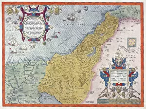
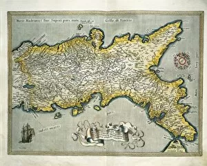
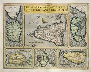
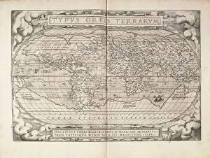
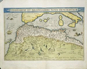
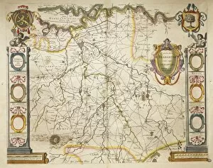
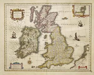
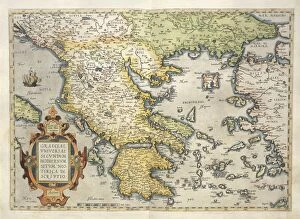
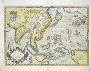
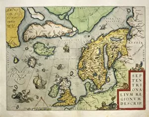
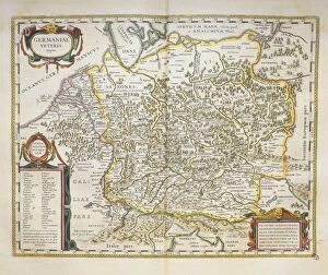
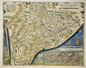
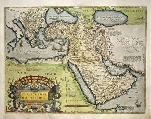
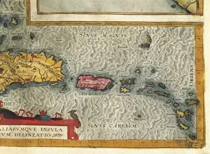
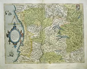
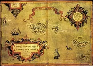
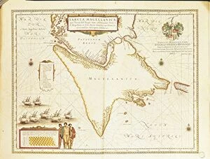
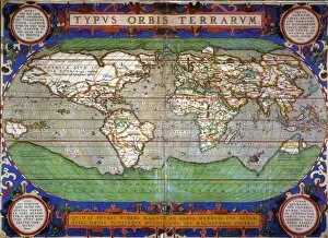
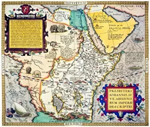
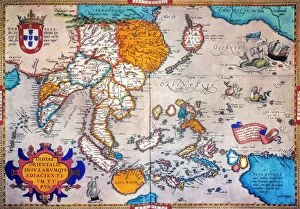
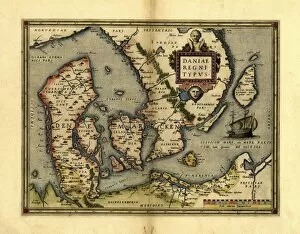
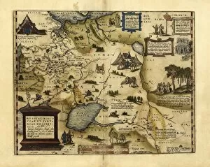
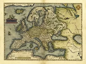
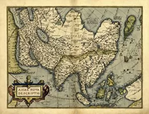
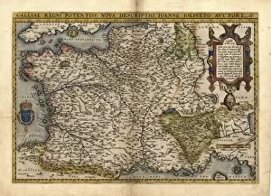
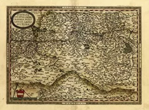
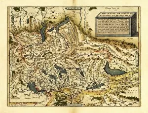
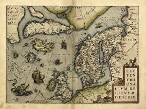
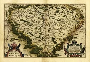
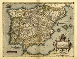
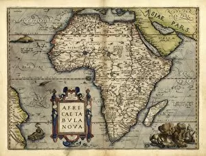
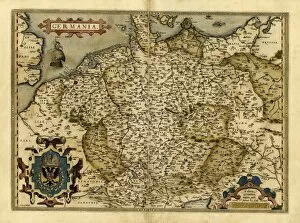
"Theatrum Orbis Terrarum: A Glimpse into the World of Cartography in the 16th Century" Step back in time and explore the fascinating world of cartography with "Theatrum Orbis Terrarum, " a renowned atlas compiled by Abraham Ortelius. This groundbreaking work, first published in 1570, revolutionized mapmaking and provided invaluable insights into various regions across the globe. One captivating feature within this collection is Orteliuss map of the Ottoman Empire from 1570. It offers a unique perspective on this powerful empire, showcasing its vast territories and intricate borders during that era. Similarly, an exquisite 16th-century map of the British Isles takes us on a journey through England, Scotland, Wales, and Ireland as they were perceived at that time. Delve further into this historical treasure trove to discover maps like "Iceland: Map" from a 1595 edition. This depiction provides an intriguing glimpse into Iceland's geography during that period while highlighting its significance within European exploration. Another remarkable inclusion is Ortelius's detailed "Map of Africa. " Published in 1595, it showcases Africa's diverse landscapes and kingdoms as known at that time—a testament to both geographical knowledge and cultural understanding during the Renaissance. Transport yourself back to ancient times with "Map of the Roman Empire. " This particular rendition unveils Rome's extensive dominion over Europe, North Africa, and parts of Asia Minor—an awe-inspiring representation capturing centuries-old power dynamics. Orteliuss prowess extends beyond empires; his maps also shed light on individual countries such as Italy (1570), Poland (1570), Greece (1570), Holland (1570), Portugal (1570). Each meticulously crafted piece provides valuable insights into these nations' topography while reflecting their political importance during this transformative era. Finally, marvel at Orteliuss grand vision with his world map from 1570.