Home > Oceania > New Zealand > Maps
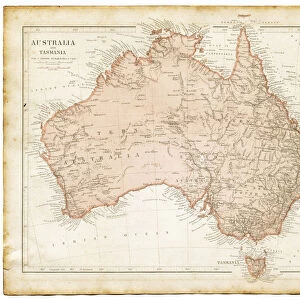
Australie Meridionale et Tasmanie. Iles Fidji ou Viti. Nouvelle- Zelande; Les Terres Du... 1914. Creator: Unknown
![]()

Wall Art and Photo Gifts from Heritage Images
Australie Meridionale et Tasmanie. Iles Fidji ou Viti. Nouvelle- Zelande; Les Terres Du... 1914. Creator: Unknown
'Australie Meridionale et Tasmanie. Iles Fidji ou Viti. Nouvelle- Zelande; Les Terres Du Pacifique, 1914. From "Grande Geographie Bong Illustree", 1914
Heritage Images features heritage image collections
Media ID 36287292
© The Print Collector/Heritage Images
Aotearoa Australasia Australia Cartography Map Making Mapmaking New Zealand
FEATURES IN THESE COLLECTIONS
> Oceania
> New Zealand
> Maps
> Oceania
> New Zealand
> Related Images
EDITORS COMMENTS
This vintage map print, titled 'Australie Meridionale et Tasmanie. Iles Fidji ou Viti. Nouvelle-Zelande; Les Terres Du Pacifique' (Southern Australia and Tasmania. Fiji or Viti Islands. New Zealand; The Lands of the Pacific), dates back to 1914. Originating from the esteemed French publication 'Grande Geographie Bong Illustree', this map offers a fascinating glimpse into the geographical knowledge of the early 20th century. The map meticulously depicts the southern regions of the Pacific Ocean, including the Australian mainland, Tasmania, and the Fiji Islands. The vibrant colors and intricate detailing showcase the cartographic advancements of the time, with each country and island represented with precision. New Zealand, labeled as 'Nouvelle-Zelande', is depicted with its North and South Islands clearly defined, while the Fiji Islands, known as 'Iles Fidji ou Viti', are intricately detailed with their individual islands named. The map also highlights various other Pacific islands and territories, providing a comprehensive representation of the region. The map's creation in 1914 places it in an era of heightened exploration and discovery, as European powers continued to expand their influence and knowledge of the world. This map serves as a testament to the rich history of cartography and the fascination with the unknown territories of the Pacific during this period. The print, which is in excellent condition, offers a captivating glimpse into the past, transporting us back to a time when the world was still being explored and mapped in detail. Its intricate design and historical significance make it a valuable addition to any collection of vintage maps or geographical memorabilia.
MADE IN THE USA
Safe Shipping with 30 Day Money Back Guarantee
FREE PERSONALISATION*
We are proud to offer a range of customisation features including Personalised Captions, Color Filters and Picture Zoom Tools
SECURE PAYMENTS
We happily accept a wide range of payment options so you can pay for the things you need in the way that is most convenient for you
* Options may vary by product and licensing agreement. Zoomed Pictures can be adjusted in the Cart.


