Home > Animals > Mammals > Cats (Domestic) > Russian White
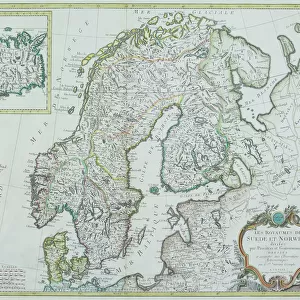
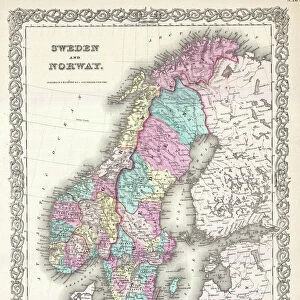
The Baltic Sea and its Coasts; Map, 1854. Creator: Unknown

![]()
Wall Art and Photo Gifts from Heritage Images
The Baltic Sea and its Coasts; Map, 1854. Creator: Unknown
The Baltic Sea and its Coasts; Map, 1854. From "Cassells Illustrated Family Paper; London Weekly 31/12/1853 - 30/12/1854"
Heritage Images features heritage image collections
Media ID 36247857
© The Print Collector/Heritage Images
FEATURES IN THESE COLLECTIONS
> Animals
> Mammals
> Cats (Domestic)
> Russian White
> Europe
> Finland
> Related Images
> Europe
> Sweden
> Related Images
The Baltic Sea and its Coasts; Map,
EDITORS COMMENTS
created in 1854, is an intriguing and historically significant engraving that offers a glimpse into the geographical knowledge of the 19th century. The image, published in "Cassell's Illustrated Family Paper; London Weekly" between December 31, 1853, and December 30, 1854, showcases the Baltic Sea and its surrounding coasts in remarkable detail. The map covers a vast area, stretching from the North Sea in the west to the Gulf of Finland in the east, and from the Danish islands in the south to the Swedish and Russian coasts in the north. The intricate depiction of the coastlines, bays, and islands reveals the extensive exploration and cartographic advancements of the time. The Baltic Sea, a vital body of water in European history, is the centerpiece of the map. Surrounded by several countries, including Denmark, Sweden, Prussia, Russia, and Finland, the map highlights the diverse cultural and political landscape of the region. The image also features various geographical features, such as the Danish archipelago, the Gulf of Bothnia, and the Baltic Proper, which were crucial to maritime trade and travel during the era. The black and white engraving, with its precise lines and meticulous detail, is a testament to the cartographic skills and knowledge of the time. Although the creator remains unknown, the map serves as an essential historical record, providing valuable insights into the geography and cartography of the Baltic region during the 19th century. This print invites us to explore the rich history and complexities of the Baltic Sea and its coastal nations.
MADE IN THE USA
Safe Shipping with 30 Day Money Back Guarantee
FREE PERSONALISATION*
We are proud to offer a range of customisation features including Personalised Captions, Color Filters and Picture Zoom Tools
FREE COLORIZATION SERVICE
You can choose advanced AI Colorization for this picture at no extra charge!
SECURE PAYMENTS
We happily accept a wide range of payment options so you can pay for the things you need in the way that is most convenient for you
* Options may vary by product and licensing agreement. Zoomed Pictures can be adjusted in the Cart.