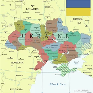
Home > Europe > Ukraine > Maps
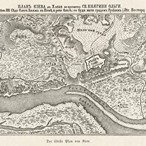
Chart showing the relative positions of the batteries and Allied Forces around Sebastopol, 1854. Creator: Unknown

![]()
Wall Art and Photo Gifts from Heritage Images
Chart showing the relative positions of the batteries and Allied Forces around Sebastopol, 1854. Creator: Unknown
Chart showing the relative positions of the batteries and Allied Forces around Sebastopol, 1854. From "Cassell's Illustrated Family Paper; London Weekly 31 Dec 1853 to 30 Dec 1854"
Heritage Images features heritage image collections
Media ID 36238733
© The Print Collector/Heritage Images
Battle Plan Cassells Illustrated Family Paper Conflict Crimean War Ottoman Empire Sebastopol Krym Ukraine Sevastopol Ukraine
FEATURES IN THESE COLLECTIONS
> Europe
> Ukraine
> Related Images
EDITORS COMMENTS
This chart, created in 1854, offers a unique perspective into the strategic positions of the batteries and Allied Forces surrounding the fortified city of Sebastopol during the Crimean War. The intricately detailed map, published in Cassell's Illustrated Family Paper, provides valuable insight into the military landscape of the Crimean Peninsula during this pivotal moment in history. The Crimean War, which lasted from 1853 to 1856, was a significant conflict between the Russian Empire and an alliance of European powers, including the United Kingdom, France, and the Ottoman Empire. The siege of Sebastopol, a major port city in the Crimea region of Ukraine, was a key battle in the war. The chart illustrates the relative positions of the various Allied forces, including British, French, and Ottoman troops, as well as the locations of the Russian batteries defending the city. The image, reminiscent of the era, offers a glimpse into the complex military maneuvers and strategic planning that took place during the siege. The chart also highlights the importance of geography in the conflict, with the strategic position of Sebastopol's harbor and the surrounding terrain playing a crucial role in the battle. The intricate details of the map also serve as a testament to the advanced cartographic techniques of the time. This rare and fascinating chart is an essential addition to any collection of historical military maps or documents related to the Crimean War or the 19th century armed forces. Its inclusion in Cassell's Illustrated Family Paper underscores the significance of the conflict and the role of media in reporting on major world events.
MADE IN THE USA
Safe Shipping with 30 Day Money Back Guarantee
FREE PERSONALISATION*
We are proud to offer a range of customisation features including Personalised Captions, Color Filters and Picture Zoom Tools
SECURE PAYMENTS
We happily accept a wide range of payment options so you can pay for the things you need in the way that is most convenient for you
* Options may vary by product and licensing agreement. Zoomed Pictures can be adjusted in the Cart.