Home > Europe > France > Heritage Sites > Pitons, cirques and remparts of Reunion
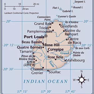
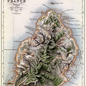
La Reunion et Maurice; Iles Africaines de la mer des Indes, 1914. Creator: Unknown

![]()
Wall Art and Photo Gifts from Heritage Images
La Reunion et Maurice; Iles Africaines de la mer des Indes, 1914. Creator: Unknown
La Reunion et Maurice; Iles Africaines de la mer des Indes, 1914. From "Grande Geographie Bong Illustree", 1914
Heritage Images features heritage image collections
Media ID 36287274
© The Print Collector/Heritage Images
Cartography Geological Map Map Making Mapmaking Mauritius
FEATURES IN THESE COLLECTIONS
> Africa
> Mauritius
> Related Images
> Animals
> Mammals
> Cercopithecidae
> Mauritius
> Europe
> France
> Heritage Sites
> Pitons, cirques and remparts of Reunion
> Maps and Charts
> Geological Map
> Maps and Charts
> Related Images
La Reunion et Maurice; Iles Africaines de la Mer des Indes,
EDITORS COMMENTS
a captivating and intricately detailed geographical map print from 1914, offers a glimpse into the cartographic knowledge of the early 20th century. The map, created by an unknown artist, showcases the Mascarene Islands of Africa, specifically focusing on the territories of Réunion and Mauritius. This stunning piece was originally published in "Grande Geographie Bong Illustree," a renowned geographical magazine of the time. The map's vibrant colors and meticulous attention to detail highlight the islands' topographical features, including mountains, bodies of water, and coastal areas. Réunion, a French department located in the southwestern Indian Ocean, is depicted with its volcanic peaks, including Piton de la Fournaise and Piton des Neiges. Mauritius, an independent island nation further east, is shown with its lush green landscapes and clear blue waters. The map also includes various geographical labels, such as capes, bays, and islands, providing valuable information for navigators and explorers of the era. The mapmaking process during the 1900s was a significant undertaking, requiring extensive research, exploration, and collaboration between cartographers, geologists, and other experts. This map serves as a testament to the advancements in geographical knowledge during the early 20th century, as well as the artistic skill and dedication of the unknown cartographer who brought this intricate representation of Réunion and Mauritius to life. The map's historical significance and visual appeal make it an essential addition to any collection focused on African geography, cartography, or the history of exploration.
MADE IN THE USA
Safe Shipping with 30 Day Money Back Guarantee
FREE PERSONALISATION*
We are proud to offer a range of customisation features including Personalised Captions, Color Filters and Picture Zoom Tools
SECURE PAYMENTS
We happily accept a wide range of payment options so you can pay for the things you need in the way that is most convenient for you
* Options may vary by product and licensing agreement. Zoomed Pictures can be adjusted in the Cart.