Home > Europe > United Kingdom > England > London > Sights > New River
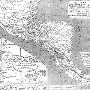
Map of Central America shewing the Proposed Routes of Communication between the Atlantic & Pacific O Creator: John Dower. Map of Central America shewing the Proposed Routes of Communication between the Atlantic & Pacific O Creator: John Dower

![]()
Wall Art and Photo Gifts from Heritage Images
Map of Central America shewing the Proposed Routes of Communication between the Atlantic & Pacific O Creator: John Dower. Map of Central America shewing the Proposed Routes of Communication between the Atlantic & Pacific O Creator: John Dower
Map of Central America shewing the Proposed Routes of Communication between the Atlantic & Pacific Oceans, 1856....and the Disputed Territories of British Honduras (Belize) & the Mosquito Shore [with] Enlarged Map of British Honduras & the Islands of Ruatan, Bonacca &c...Reference for the several proposed routes of interoceanic communiciation: Proposed Canal by way of R. Sapoa...to Pacific Ocean...Railway [via] R. Lajas...to Port S. Juan...Canal from L. Managua to Port of Tamarinda...[Canal from L. Managua] to Realejo...by the Plain of Leon...[Canal from L. Managua] to Gulf of Fonseca...Canal to unite R. Coazacalco (Gulf of Campeche) Atlantic Ocean with the R. Chicapa (Gulf of Tehuantepec)...The River San Juan is 90 miles in length. [Key for] Panama Railway...proposed Honduras Railway and others'. European exploitation of the New World, note Gold District and native tribes. From "Illustrated London News", 1856
Heritage Images features heritage image collections
Media ID 36322196
© /Heritage Images
Canal Canals Caribbean Central America Civil Engineering Colony Costa Rica Disputed Territory Dower J Dower John Dower John James Engineering Exploitation Guatemala Honduras Imperialism Island Islands Isthmus J Dower John Dower John James Dower Mexico Nicaragua Ocean Pacific Ocean Railways Raw Materials Territorial Territory Yucatan Belize British Empire British Honduras Isthmus Of Panama Lake Nicaragua
FEATURES IN THESE COLLECTIONS
> Animals
> Mammals
> Muridae
> Plains Mouse
> Arts
> Artists
> W
> John White
> Europe
> United Kingdom
> England
> London
> Sights
> New River
> Europe
> United Kingdom
> England
> London
> Transport
> Railway
> Historic
> Colonial America illustrations
> Colonial America
> Maps and Charts
> British Empire Maps
> Maps and Charts
> World
> North America
> Belize
> Maps
> North America
> Belize
> Related Images
EDITORS COMMENTS
This map, titled "Map of Central America shewing the Proposed Routes of Communication between the Atlantic & Pacific Oceans," was created by John Dower in 1856. The map provides a detailed view of Central America, highlighting the proposed routes for interoceanic communication, aimed at connecting the Atlantic and Pacific Oceans. The map includes several proposed routes, such as the canal by way of the Rio Sapoa, railway via Rio Lajas to Port San Juan, canal from Lake Managua to Port Tamarinda, and the canal from Lake Managua to Gulf of Fonseca. Additionally, an enlarged map of British Honduras (Belize) and the islands of Roatan, Bonacca, and others is included in the print. The map serves as a testament to the European exploration and interest in Central America during the 19th century. The proposed routes for interoceanic communication were a significant undertaking, driven by the desire to shorten travel times and facilitate trade and diplomatic relations between the Atlantic and Pacific worlds. The map also highlights the disputed territories of British Honduras and the Mosquito Shore, reflecting the political tensions and territorial claims of the time. The European influence is further evident in the depiction of the "Gold District" and various native tribes. The map was published in the Illustrated London News, providing insight into the geographical and political knowledge of the era. The proposed routes and territorial claims represented in this map played a crucial role in shaping the future of Central America and its relationship with the wider world.
MADE IN THE USA
Safe Shipping with 30 Day Money Back Guarantee
FREE PERSONALISATION*
We are proud to offer a range of customisation features including Personalised Captions, Color Filters and Picture Zoom Tools
FREE COLORIZATION SERVICE
You can choose advanced AI Colorization for this picture at no extra charge!
SECURE PAYMENTS
We happily accept a wide range of payment options so you can pay for the things you need in the way that is most convenient for you
* Options may vary by product and licensing agreement. Zoomed Pictures can be adjusted in the Cart.