Home > Europe > United Kingdom > Northern Ireland > County Down > Newcastle
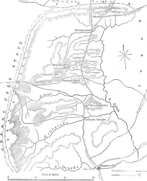
Map of the Country between Newcastle and the Transvaal, c1880
![]()

Wall Art and Photo Gifts from Heritage Images
Map of the Country between Newcastle and the Transvaal, c1880
Map of the Country between Newcastle and the Transvaal, c1880. From British Battles on Land and Sea, Vol. IV, by James Grant. [Cassell Petter & Galpin, London, Paris & Melbourne, c1880]
Heritage Images features heritage image collections
Media ID 14991929
© The Print Collector
Anglo Zulu Wars British Battles On Land And Sea Cassell Petter Galpin Grant Imperialism James Grant Kwazulu Natal Military Operation Newcastle Petter Galpin Plan South Africa South African Strategy Transvaal Zulu Wars Cassell
FEATURES IN THESE COLLECTIONS
> Africa
> South Africa
> Maps
> Africa
> South Africa
> Related Images
> Arts
> Literature
> Europe
> France
> Canton
> Landes
> Europe
> France
> Paris
> Maps
> Europe
> United Kingdom
> Northern Ireland
> County Down
> Newcastle
> Historic
> Battles
> Related Images
> Maps and Charts
> Related Images
EDITORS COMMENTS
This print showcases a historical map titled "Map of the Country between Newcastle and the Transvaal, c1880". The artwork is part of the book "British Battles on Land and Sea, Vol. IV" by James Grant, published by Cassell Petter & Galpin in London, Paris, and Melbourne around 1880. The map provides a detailed depiction of the landscape between Newcastle and Transvaal in South Africa during the late 19th century. It was likely used for military strategy purposes during that time period. This particular region holds significant importance due to its involvement in various conflicts such as the Zulu Wars and Anglo-Zulu Wars. The monochrome aesthetic adds an air of authenticity to this piece, emphasizing its historical value. As one explores this intricate map, it becomes evident that it served as a crucial tool for British forces operating in South Africa at that time. With its precise cartography and strategic markings, this print offers insight into Britain's imperialistic ambitions during the 19th century. It serves as both a literary concept within Grant's book and an invaluable resource for understanding military operations conducted in this region. Overall, this print captures not only geographical information but also represents an era marked by exploration, conflict, imperialism, and evolving international relations between Britain and South Africa.
MADE IN THE USA
Safe Shipping with 30 Day Money Back Guarantee
FREE PERSONALISATION*
We are proud to offer a range of customisation features including Personalised Captions, Color Filters and Picture Zoom Tools
SECURE PAYMENTS
We happily accept a wide range of payment options so you can pay for the things you need in the way that is most convenient for you
* Options may vary by product and licensing agreement. Zoomed Pictures can be adjusted in the Cart.

