Home > Europe > United Kingdom > England > London > Politics > John Major
Map of the Trans-Mississippi of the United States during the period of the American fur... 1902. Creator: Hiram Martin Chittenden

![]()
Wall Art and Photo Gifts from Heritage Images
Map of the Trans-Mississippi of the United States during the period of the American fur... 1902. Creator: Hiram Martin Chittenden
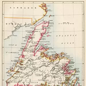
Map of the Trans-Mississippi of the United States during the period of the American fur trade as conducted from St. Louis between the years 1807 and 1843, 1902. This map, published in 1902 in H.M. Chittenden's History of the Fur Trade of the Far West, shows major cartographic features of the American West in the early 19th century, including the location of key Native American populations, forts, trading posts, and physical features, such as mountains and rivers. French voyageurs pioneered fur trading and trapping in Canada and the American West before the Louisiana Purchase of 1803, but the basic geography of this vast region was poorly understood before the Lewis and Clark expedition of 1804-6. Following the expedition, the fur trade rapidly expanded in the region between the Mississippi River and the Pacific Ocean. One of the most famous American fur traders, John Jacob Astor, established his Pacific Fur Company in 1810 near the mouth of the Columbia River in Astoria, Oregon
Heritage Images features heritage image collections
Media ID 35127681
© Heritage Art/Heritage Images
Cartographic Cartography Direction Fort Fur Trade Map Making Mapmaking Mississippi Mississippi River North America North American Population River Mississippi Rivers Trading Post West Western Fortifications Meeting Of Frontiers
FEATURES IN THESE COLLECTIONS
> Arts
> Artists
> J
> Jacob Jacobs
> Arts
> Artists
> L
> Martin Lewis
> Arts
> Artists
> M
> John Martin
> Europe
> United Kingdom
> England
> London
> Politics
> John Major
> Maps and Charts
> Early Maps
> North America
> Canada
> Maps
> North America
> Canada
> Related Images
EDITORS COMMENTS
This map, titled 'Map of the Trans-Mississippi of the United States during the period of the American fur trade as conducted from St. Louis between the years 1807 and 1843,' was created by Hiram Martin Chittenden and published in 1902. The map is an essential historical document that illustrates the major cartographic features of the American West during the early 19th century. It highlights the locations of significant Native American populations, forts, trading posts, and physical features, such as mountains and rivers. Before the Louisiana Purchase of 1803, French voyageurs had pioneered fur trading and trapping in Canada and the American West. However, the geography of this vast region was poorly understood, and the Lewis and Clark expedition of 1804-1806 played a crucial role in mapping and exploring the area. Following the expedition, the fur trade rapidly expanded between the Mississippi River and the Pacific Ocean. One of the most famous American fur traders, John Jacob Astor, established his Pacific Fur Company in 1810 near the mouth of the Columbia River in Astoria, Oregon. This map provides a fascinating glimpse into the early history of the American West and the role that the fur trade played in shaping the region's development. Chittenden's meticulous attention to detail and commitment to historical accuracy make this map an invaluable resource for scholars, historians, and anyone interested in the history of the American West.
MADE IN THE USA
Safe Shipping with 30 Day Money Back Guarantee
FREE PERSONALISATION*
We are proud to offer a range of customisation features including Personalised Captions, Color Filters and Picture Zoom Tools
SECURE PAYMENTS
We happily accept a wide range of payment options so you can pay for the things you need in the way that is most convenient for you
* Options may vary by product and licensing agreement. Zoomed Pictures can be adjusted in the Cart.