Home > Animals > Fishes > Related Images
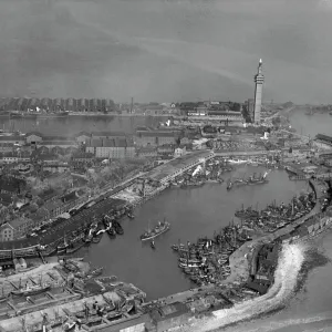
Plan of Petropaulovski, 1854. Creator: Unknown

![]()
Wall Art and Photo Gifts from Heritage Images
Plan of Petropaulovski, 1854. Creator: Unknown
Plan of Petropaulovski, [Kamchatka], 1854. Crimean War: map showing...position of the [Allied] Fleet and [Russian] Batteries, the town, mountains, harbour etc. Magazine; Government House; Landing-place; Barracks; Fish-house; Cemetery; Gorge Battery, 5 guns; Saddle Battery, 7 guns; Point Battery, 5 guns; Inner Battery, 5 guns; Path Battery, 5 guns; Snake-in-Grass Battery, 11 guns; Parkers's Battery, 3 guns; Garden Battery, 5 guns; Citadel Battery, number of guns unknown...the squadron made their way to Awatska Bay, the approach to which is very grand - high mountains (volcanoes) appearing on either side, covered with snow, and looking magnificent amongst the clouds. On one side of the bay...we perceived a lighthouse; in front of which, and commanding the entrance, is a large gun, which, as we neared the land, was fired, to give the alarm to the batteries and town...'. From "Illustrated London News", 1854
Heritage Images features heritage image collections
Media ID 36245577
© The Print Collector/Heritage Images
Artillery Attack Attacking Avacha Bay Batteries Battery Besieged Crimean War Defence Defences Fleet Kamchatka Naval Ship Petropaulovski Russia Petropavlovsk Kamchatskiy Port Royal Navy Siege Squadron Volcano Warships Naval Warfare Warship
FEATURES IN THESE COLLECTIONS
> Animals
> Fishes
> Related Images
> Animals
> Mammals
> Cats (Domestic)
> Russian White
> Animals
> Reptiles
> Snakes
> Black Snake
> Related Images
> Animals
> Reptiles
> Snakes
> Grass Snake
> Animals
> Reptiles
> Snakes
> Water Snake
> Related Images
> Arts
> Literature
> Magazines
> Europe
> France
> Canton
> Landes
> Europe
> Russia
> Heritage Sites
> Volcanoes of Kamchatka 20
EDITORS COMMENTS
This map print, titled "Plan of Petropaulovski, Kamchatka, 1854," provides a detailed and intriguing glimpse into the strategic landscape of a key battleground during the Crimean War. The creator of this map remains unknown, but it was first published in the esteemed "Illustrated London News" in 1854. The map meticulously outlines the position of the Allied Fleet and Russian batteries, as well as the town, mountains, harbor, and various fortifications such as the Magazine, Government House, Landing-place, Barracks, Fish-house, Cemetery, Gorge Battery, Saddle Battery, Point Battery, Inner Battery, Path Battery, Snake-in-Grass Battery, Parkers's Battery, and Garden Battery. The map also notes the presence of the Citadel Battery, though the number of guns is unknown. The map transports us back to a time of naval warfare and siege, as the squadron made their way to Awatska Bay. The approach to this bay is described as grand, with high mountains (volcanoes) appearing on either side, covered in snow, and looking magnificent amongst the clouds. The map's intricate details offer a fascinating perspective on the geography and defenses of Petropaulovski, Kamchatka, a vital location in the larger context of the Crimean War. This print serves as an essential historical record, providing valuable insights into the military strategies and tactics employed during this pivotal period in world history.
MADE IN THE USA
Safe Shipping with 30 Day Money Back Guarantee
FREE PERSONALISATION*
We are proud to offer a range of customisation features including Personalised Captions, Color Filters and Picture Zoom Tools
SECURE PAYMENTS
We happily accept a wide range of payment options so you can pay for the things you need in the way that is most convenient for you
* Options may vary by product and licensing agreement. Zoomed Pictures can be adjusted in the Cart.