Home > Animals > Mammals > Muridae > Desert Mouse
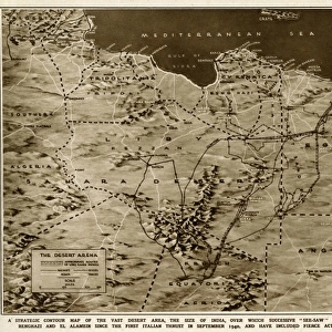
Relief Map of Algerie, 1914. Creator: Unknown

![]()
Wall Art and Photo Gifts from Heritage Images
Relief Map of Algerie, 1914. Creator: Unknown
Relief Map of Algerie, 1914. From "Grande Geographie Bong Illustree", 1914
Heritage Images features heritage image collections
Media ID 36294505
© The Print Collector/Heritage Images
Algeria Africa Cartography Colonies Colony Desert Map Making Mapmaking Mediterranean Sea North Africa North African Sahara Sahara Desert Africa Relief Map
FEATURES IN THESE COLLECTIONS
> Africa
> Algeria
> Related Images
> Animals
> Mammals
> Muridae
> Desert Mouse
> Maps and Charts
> Related Images
EDITORS COMMENTS
This Relief Map of Algerie, created in 1914, offers a unique glimpse into the colonial era's cartographic exploration of North Africa. The map, from the esteemed publication "Grande Geographie Bong Illustree," showcases the intricate topography of Algeria during a pivotal time in its history. The map's vibrant colors and intricate engravings highlight the diverse geographical features of this North African country. The Mediterranean Sea, with its shimmering blue hue, frames the western coast, while the vast expanse of the Sahara Desert, depicted in golden sand tones, dominates the eastern and southern regions. As a French colony, Algeria was a significant part of the French Empire, and this map reflects the meticulous detail and pride taken in documenting and understanding its new territories. The map's title, "Algerie," is written in bold, clear letters, emphasizing the importance of this region to the French colonial project. The map's relief features are particularly noteworthy, with mountain ranges and valleys depicted in three dimensions, providing a more accurate representation of the land's true form. The map also highlights key locations, including major cities, rivers, and geographical landmarks, making it an essential tool for exploration and administration. This Relief Map of Algerie, created in the 1910s, offers a fascinating window into the colonial era's cartographic exploration of Africa. Its intricate details and vibrant colors continue to captivate viewers, making it an essential addition to any collection focused on African history, cartography, or colonialism.
MADE IN THE USA
Safe Shipping with 30 Day Money Back Guarantee
FREE PERSONALISATION*
We are proud to offer a range of customisation features including Personalised Captions, Color Filters and Picture Zoom Tools
SECURE PAYMENTS
We happily accept a wide range of payment options so you can pay for the things you need in the way that is most convenient for you
* Options may vary by product and licensing agreement. Zoomed Pictures can be adjusted in the Cart.