Home > Arts > Artists > T > Wilhelm Gottlieb Tilesius von Tilenau
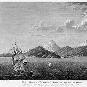
View of the Seashore Near Port Chichagov, 1813. Creator: Koz'ma Vasil'evich Chesky

![]()
Wall Art and Photo Gifts from Heritage Images
View of the Seashore Near Port Chichagov, 1813. Creator: Koz'ma Vasil'evich Chesky
View of the Seashore Near Port Chichagov, 1813.
In 1803-06, Captain I. F. Kruzenshtern became the first Russian to circumnavigate the globe. This atlas, published by the Russian Academy of Sciences in 1813, includes maps of Kruzenshtern's route and 109 plates based upon the drawings of V. G. Tilesius, a doctor, naturalist, and the official artist of the expedition. It is one of the largest publications of engravings from tsarist Russia. The subjects depicted include views of Sakhalin, Kamchatka, and the Kurile Islands; representations of Siberian natives and other peoples encountered during the voyage; and local fish and birds from throughout the South and North Pacific
Heritage Images features heritage image collections
Media ID 35132261
© Heritage Art/Heritage Images
Adam Johann Von Krusenstern Ashore Atlas Circumnavigation Expedition Exploration Exploring Graphics Ivan Fyodorovich Kruzenshtern Krusenstern Adam Johann Von Kruzenshtern Ivan Fyodorovich National Library Of Russia Navigation Port Russian Academy Of Sciences Russian Empire Seashore Shore Tilenau Vilgelma Gottliba Tilesius V G Tilesius Von Tilenau Wilhelm Gottlieb Tilesius Wilhelm Gottlieb V G Tilesius Voyage Wilhelm Gottlieb Tilesius Wilhelm Gottlieb Tilesius Von Tilenau Atoll Meeting Of Frontiers
FEATURES IN THESE COLLECTIONS
> Animals
> Fishes
> Related Images
> Animals
> Mammals
> Cats (Domestic)
> Russian White
> Animals
> Mammals
> Muridae
> Water Mouse
> Arts
> Artists
> T
> Wilhelm Gottlieb Tilesius von Tilenau
> Arts
> Realistic drawings
> Figure drawing
> Fine art portraits
> Europe
> Russia
> Related Images
> Maps and Charts
> Early Maps
> Maps and Charts
> Related Images
View of the Seashore Near Port Chichagov,
EDITORS COMMENTS
an enchanting print by Russian artist Koz'ma Vasil'evich Chesky, showcases the breathtaking beauty of the seashore as observed during the historic circumnavigation expedition led by Captain Ivan Fyodorovich Kruzenshtern between 1803 and 1806. This image is part of the extensive atlas published by the Russian Academy of Sciences in 1813, featuring 109 plates based on the drawings of V.G. Tilesius, the expedition's doctor, naturalist, and official artist. This atlas, one of the largest publications of engravings from tsarist Russia, offers a captivating glimpse into the geographical features, peoples, and cultures encountered during the voyage. The subjects depicted in this print include a serene seashore scene near Port Chichagov, with boats anchored in the calm waters and figures of people meeting at the shoreline. The print's intricate detail and masterful shading techniques bring the scene to life, transporting viewers to a time when the world was still being explored and documented. This evocative image is a testament to the rich cultural heritage of Russia and its significant role in the history of exploration and cartography. The print's historical significance is further emphasized by its inclusion in the collections of prestigious institutions such as the Library of Congress and the National Library of Russia. "View of the Seashore Near Port Chichagov" is a must-have for any collection focused on the 19th century, art, geography, or the history of exploration.
MADE IN THE USA
Safe Shipping with 30 Day Money Back Guarantee
FREE PERSONALISATION*
We are proud to offer a range of customisation features including Personalised Captions, Color Filters and Picture Zoom Tools
SECURE PAYMENTS
We happily accept a wide range of payment options so you can pay for the things you need in the way that is most convenient for you
* Options may vary by product and licensing agreement. Zoomed Pictures can be adjusted in the Cart.