Home > Animals > Mammals > Muridae > Desert Mouse
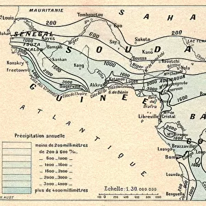
Zones de vegetation; L'Ouest Africain, 1914. Creator: Unknown

![]()
Wall Art and Photo Gifts from Heritage Images
Zones de vegetation; L'Ouest Africain, 1914. Creator: Unknown
Zones de vegetation; L'Ouest Africain, 1914. From "Grande Geographie Bong Illustree", 1914
Heritage Images features heritage image collections
Media ID 36295245
© The Print Collector/Heritage Images
Atlantic Ocean Cartography Central Africa Central African Climate Desert Equatorial Gulf Gulf Of Guinea Jungle Map Making Mapmaking Ocean Rainforest Sahara Sahara Desert Africa Sahel Vegetation West Africa West African Congo Basin
FEATURES IN THESE COLLECTIONS
> Africa
> Equatorial Guinea
> Maps
> Africa
> Equatorial Guinea
> Related Images
> Africa
> Guinea
> Related Images
> Animals
> Mammals
> Muridae
> Desert Mouse
> Arts
> Landscape paintings
> Forest and woodland scenes
> Forest artwork
> Maps and Charts
> Related Images
EDITORS COMMENTS
This print, titled "Zones de vegetation; L'Ouest Africain" (Zones of Vegetation; West Africa), was created in 1914. The origin of the print is unknown, but it was published in the French magazine "Grande Geographie Illustree" (The Great Illustrated Geography) of the same year. The map depicts the vegetation zones of West Africa, stretching from the Atlantic Ocean in the west to the Central African Republic and the Congo Basin in the east. The map highlights various geographical features, including the Sahara Desert in the north, the Sahel region, and the equatorial forests. The print also shows the Fouta Djallon plateau, the Gulf of Guinea, and the Congo River. The mapmaking technique used is engraving, which was a common method for producing detailed and accurate maps during the early 20th century. The climate of West Africa is depicted through the different vegetation zones. The arid Sahara Desert is shown in stark contrast to the lush rainforests in the equatorial region. The Sahel, a transitional zone between the desert and the savanna, is also represented. The map provides a snapshot of the diverse geography and climate of West Africa during a time when European powers were actively exploring and colonizing the continent. The print is an important historical document, offering insights into the cartographic knowledge of the region during the early 20th century. It also highlights the role of French mapmakers and publishers in documenting and disseminating geographical information about Africa. Today, this print serves as a reminder of the rich history and cultural significance of West Africa and its diverse landscapes.
MADE IN THE USA
Safe Shipping with 30 Day Money Back Guarantee
FREE PERSONALISATION*
We are proud to offer a range of customisation features including Personalised Captions, Color Filters and Picture Zoom Tools
SECURE PAYMENTS
We happily accept a wide range of payment options so you can pay for the things you need in the way that is most convenient for you
* Options may vary by product and licensing agreement. Zoomed Pictures can be adjusted in the Cart.