Jigsaw Puzzle > Europe > Republic of Ireland > Maps
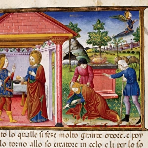
Jigsaw Puzzle : Ireland divided into its four province of Ulster, Munster, Connacht and Leinster. After a map published in 1700


![]()
Jigsaw Puzzles from Design Pics
Ireland divided into its four province of Ulster, Munster, Connacht and Leinster. After a map published in 1700
Design Pics offers Distinctively Different Imagery representing over 1,500 contributors
Media ID 24906473
© Ken Welsh
17th Century Connacht Divided Geographical Geography Irish Leinster Munster Provinces Ulster 1700
Jigsaw Puzzle (520 Pieces)
Discover the rich history and culture of Ireland with our exquisite jigsaw puzzle from Media Storehouse. Featuring a captivating image of Ireland divided into its four historic provinces - Ulster, Munster, Connacht, and Leinster - as depicted in a map published in 1700. This intricately detailed puzzle, sourced from Design Pics and created by artist Ken Welsh, offers a unique and educational experience for puzzle enthusiasts of all ages. Immerse yourself in the beauty and history of Ireland while enhancing problem-solving skills and fostering a sense of accomplishment as you piece together this stunning puzzle.
Made in the USA, 520-piece puzzles measure 16" x 20" (40.6 x 50.8 cm). Every puzzle is meticulously printed on glossy photo paper, which has a strong 1.33 mm thickness. Delivered in a black storage cardboard box, these puzzles are both stylish and practical. (Note: puzzles contain small parts and are not suitable for children under 3 years of age.)
Jigsaw Puzzles are an ideal gift for any occasion
Estimated Product Size is 40.5cm x 50.8cm (15.9" x 20")
These are individually made so all sizes are approximate
Artwork printed orientated as per the preview above, with landscape (horizontal) or portrait (vertical) orientation to match the source image.
FEATURES IN THESE COLLECTIONS
> Europe
> Republic of Ireland
> Maps
> Maps and Charts
> Early Maps
EDITORS COMMENTS
This print takes us back in time to the 18th century, showcasing a map of Ireland divided into its four provinces: Ulster, Munster, Connacht, and Leinster. The intricate details and historical significance of this illustration make it a true gem for any history enthusiast or lover of Irish culture. Originally published in 1700, this map provides a fascinating glimpse into the geographical layout of Ireland during that era. It serves as a reminder of how borders and divisions have shaped the country's rich heritage over centuries. Ken Welsh's archival print beautifully captures the essence of this piece, allowing us to appreciate its historical value while adding an artistic touch to any space. Whether displayed in a home library or office setting, this image sparks curiosity and invites exploration into Ireland's past. As we gaze upon this remarkable depiction, we can't help but marvel at the intricacy with which each province is delineated. The attention to detail showcases not only Welsh's talent as an artist but also highlights the importance placed on accurate cartography during that period. For those who cherish history or simply admire beautiful artwork inspired by old maps, this print offers both aesthetic pleasure and educational value. It serves as a visual testament to Ireland's complex past while reminding us of the enduring power that geography holds in shaping our world.
MADE IN THE USA
Safe Shipping with 30 Day Money Back Guarantee
FREE PERSONALISATION*
We are proud to offer a range of customisation features including Personalised Captions, Color Filters and Picture Zoom Tools
SECURE PAYMENTS
We happily accept a wide range of payment options so you can pay for the things you need in the way that is most convenient for you
* Options may vary by product and licensing agreement. Zoomed Pictures can be adjusted in the Cart.