Jigsaw Puzzle > Asia > Yemen > Maps
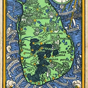
Jigsaw Puzzle : The Indian Empire And Ceylon Circa 1930


![]()
Jigsaw Puzzles from Design Pics
The Indian Empire And Ceylon Circa 1930
Design Pics offers Distinctively Different Imagery representing over 1,500 contributors
Media ID 24601050
© UIG / Design Pics
Ceylon Daniel Empire India Maps Russelman Wars World Aden Lanka Yemen
Jigsaw Puzzle (1014 Pieces)
Delve into the rich history of the Indian subcontinent and Ceylon (now Sri Lanka) with our stunning jigsaw puzzle from the Media Storehouse collection. This intricately detailed puzzle, featuring the captivating image "The Indian Empire And Ceylon Circa 1930" from Design Pics, offers an engaging and educational experience. Immerse yourself in the vibrant colors and intricate patterns as you piece together this beautiful representation of a bygone era. Perfect for history enthusiasts, puzzle lovers, or anyone seeking a challenging yet rewarding activity. Add this puzzle to your collection and transport yourself on a journey through time.
Made in the USA, 1014-piece puzzles measure 20" x 30" (50.8 x 76.2 cm). Every puzzle is meticulously printed on glossy photo paper, which has a strong 1.33 mm thickness. Delivered in a black storage cardboard box, these puzzles are both stylish and practical. (Note: puzzles contain small parts and are not suitable for children under 3 years of age.)
Jigsaw Puzzles are an ideal gift for any occasion
Estimated Product Size is 76cm x 50.8cm (29.9" x 20")
These are individually made so all sizes are approximate
Artwork printed orientated as per the preview above, with landscape (horizontal) orientation to match the source image.
FEATURES IN THESE COLLECTIONS
> Design Pics
> Universal Images Group
> Design Pics
> Update - March 23, 2022
> Asia
> India
> Related Images
> Asia
> Sri Lanka
> Related Images
> Asia
> Yemen
> Related Images
> Maps and Charts
> British Empire Maps
> Maps and Charts
> India
> Maps and Charts
> Related Images
EDITORS COMMENTS
This print titled "The Indian Empire And Ceylon Circa 1930" takes us back in time to the era of British colonial rule. The image showcases a beautifully detailed map, meticulously hand-drawn by Daniel Russelman, depicting the vast territories encompassing the Indian Empire and Ceylon (now known as Sri Lanka). As we gaze upon this historical artifact, we are transported to an era when borders were different, and empires held sway over distant lands. The intricate details on the map highlight not only the geographical features but also provide insights into political boundaries during that period. The British Empire's influence is prominently displayed through its territorial control over India and Ceylon. This visual representation allows us to appreciate the magnitude of their dominion across these regions. Additionally, it serves as a reminder of how colonization shaped history and impacted societies. Notably, this map extends beyond just India and Ceylon; it includes Aden in Yemen too. Such inclusion emphasizes Britain's strategic interests in maintaining control over crucial trade routes connecting Europe with Asia. This print from Design Pics offers a unique opportunity for history enthusiasts to delve into the past while admiring Daniel Russelman's exceptional cartographic skills. It stands as a testament to both artistry and historical significance – reminding us of our shared global heritage while evoking curiosity about world events during that time period.
MADE IN THE USA
Safe Shipping with 30 Day Money Back Guarantee
FREE PERSONALISATION*
We are proud to offer a range of customisation features including Personalised Captions, Color Filters and Picture Zoom Tools
SECURE PAYMENTS
We happily accept a wide range of payment options so you can pay for the things you need in the way that is most convenient for you
* Options may vary by product and licensing agreement. Zoomed Pictures can be adjusted in the Cart.