Jigsaw Puzzle > Asia > Yemen > Maps
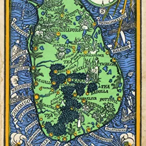
Jigsaw Puzzle : The Indian Empire And Ceylon Circa 1930. Inset Shows Aden. From The Modern Atlas Of The World Published Circa 1930


![]()
Jigsaw Puzzles from Design Pics
The Indian Empire And Ceylon Circa 1930. Inset Shows Aden. From The Modern Atlas Of The World Published Circa 1930
Design Pics offers Distinctively Different Imagery representing over 1,500 contributors
Media ID 18193040
© Ken Welsh / Design Pics
Ceylon Empire India Maps Wars World Aden Lanka Yemen
Jigsaw Puzzle (1014 Pieces)
Discover the rich history of the Indian Empire and Ceylon, as depicted in this captivating jigsaw puzzle from Media Storehouse. Featuring an intricately detailed image from The Modern Atlas Of The World published circa 1930 by Ken Welsh from Design Pics, this puzzle invites you on a journey through time. The large, vibrant map showcases the Indian Empire and Ceylon in its entirety, with an inset image of Aden offering a closer look at this historic region. Ideal for history enthusiasts, puzzle collectors, or anyone seeking a challenging and engaging activity, this jigsaw puzzle promises hours of entertainment and a beautiful, completed display piece. Immerse yourself in the past and piece together this captivating image of a bygone era.
Made in the USA, 1014-piece puzzles measure 20" x 30" (50.8 x 76.2 cm). Every puzzle is meticulously printed on glossy photo paper, which has a strong 1.33 mm thickness. Delivered in a black storage cardboard box, these puzzles are both stylish and practical. (Note: puzzles contain small parts and are not suitable for children under 3 years of age.)
Jigsaw Puzzles are an ideal gift for any occasion
Estimated Product Size is 76cm x 50.8cm (29.9" x 20")
These are individually made so all sizes are approximate
Artwork printed orientated as per the preview above, with landscape (horizontal) orientation to match the source image.
FEATURES IN THESE COLLECTIONS
> Asia
> India
> Related Images
> Asia
> Sri Lanka
> Related Images
> Asia
> Yemen
> Related Images
> Maps and Charts
> British Empire Maps
> Maps and Charts
> India
EDITORS COMMENTS
This print takes us back in time to the early 1930s, showcasing "The Indian Empire and Ceylon". A remarkable piece from "The Modern Atlas of the World" published around that era, this map offers a glimpse into the vast British empire during its heyday. The intricate details and vibrant colors bring to life an era of exploration, conquest, and cultural exchange. Intriguingly, an inset reveals Aden—a strategic port city located in present-day Yemen—highlighting its significance within this expansive empire. This inclusion provides a fascinating perspective on the interconnectedness of global trade routes during that period. "The Indian Empire and Ceylon" evokes thoughts of historical events such as colonial rule, wars fought for control over territories, and the rich tapestry of cultures found across India and Sri Lanka (then known as Ceylon). It serves as a visual reminder of how these regions were shaped by their interactions with British imperialism. Ken Welsh's masterful reproduction ensures that this vintage gem can be appreciated by contemporary audiences. Whether you are an avid historian or simply captivated by cartography's beauty, this print is sure to spark curiosity about our world's past. Display it proudly on your wall or use it as a conversation starter among friends—it is bound to transport you back in time while offering new insights into our shared history.
MADE IN THE USA
Safe Shipping with 30 Day Money Back Guarantee
FREE PERSONALISATION*
We are proud to offer a range of customisation features including Personalised Captions, Color Filters and Picture Zoom Tools
SECURE PAYMENTS
We happily accept a wide range of payment options so you can pay for the things you need in the way that is most convenient for you
* Options may vary by product and licensing agreement. Zoomed Pictures can be adjusted in the Cart.