Jigsaw Puzzle > Maps and Charts > World
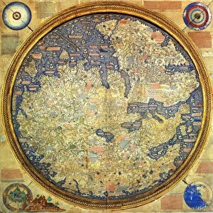
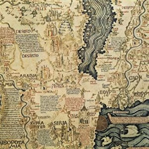
Jigsaw Puzzle : Map Of Fra Mauro, 1457 - 1459. From The Book Life Of Christopher Columbus By Clements R. Markham Published 1892


![]()
Jigsaw Puzzles from Design Pics
Map Of Fra Mauro, 1457 - 1459. From The Book Life Of Christopher Columbus By Clements R. Markham Published 1892
Design Pics offers Distinctively Different Imagery representing over 1,500 contributors
Media ID 18177180
© Hilary Jane Morgan / Design Pics
15th Cartography Chart Circular Fifteenth Geographical Geography Mapmaking Mediaeval Medieval Middle Ages World Mapamundi Mauro Planisphere
Jigsaw Puzzle (520 Pieces)
Discover the wonders of the past with our captivating jigsaw puzzle from the Media Storehouse collection. This intricately detailed puzzle showcases the iconic Map of Fra Mauro, dating back to 1457-1459. Originally found in The Book of Christopher Columbus by Clements R. Markham published in 1892, this historical map is a testament to the explorative spirit of the Renaissance era. Solve the puzzle pieces to reveal the vivid colors and intricate lines of this ancient cartography masterpiece, making for an enriching and educational experience. Bring history to life in the comfort of your own home with our premium quality jigsaw puzzles.
Made in the USA, 520-piece puzzles measure 16" x 20" (40.6 x 50.8 cm). Every puzzle is meticulously printed on glossy photo paper, which has a strong 1.33 mm thickness. Delivered in a black storage cardboard box, these puzzles are both stylish and practical. (Note: puzzles contain small parts and are not suitable for children under 3 years of age.)
Jigsaw Puzzles are an ideal gift for any occasion
Estimated Product Size is 40.5cm x 50.8cm (15.9" x 20")
These are individually made so all sizes are approximate
Artwork printed orientated as per the preview above, with landscape (horizontal) or portrait (vertical) orientation to match the source image.
FEATURES IN THESE COLLECTIONS
> Design Pics
> Design Pics Art
> Art llustrations and Engravings
> Maps and Charts
> Related Images
> Maps and Charts
> World
EDITORS COMMENTS
This print showcases the remarkable "Map Of Fra Mauro" from the 15th century, meticulously preserved in the book "Life of Christopher Columbus" by Clements R. Markham, published in 1892. The map itself was created between 1457 and 1459 by Fra Mauro, an esteemed cartographer of his time. Displayed on this circular planisphere is a mesmerizing depiction of the world as it was understood during the medieval era. Every inch of this intricate map exudes a sense of historical significance and intellectual curiosity that defined the Middle Ages. As one delves into this masterpiece, they are transported back to a time when cartography was still in its infancy but held immense importance for understanding our planet's geography. This mapamundi provides us with invaluable insights into how people perceived and navigated their world centuries ago. The attention to detail is awe-inspiring; each continent, ocean, mountain range, and city is painstakingly illustrated with precision. It serves as a testament to human ingenuity and determination to explore beyond known horizons. Hilary Jane Morgan's expert photography captures every nuance of this extraordinary piece with utmost clarity and reverence. Whether you are an avid historian or simply fascinated by ancient maps, this print will undoubtedly transport you through time while igniting your imagination about our collective journey across continents throughout history.
MADE IN THE USA
Safe Shipping with 30 Day Money Back Guarantee
FREE PERSONALISATION*
We are proud to offer a range of customisation features including Personalised Captions, Color Filters and Picture Zoom Tools
SECURE PAYMENTS
We happily accept a wide range of payment options so you can pay for the things you need in the way that is most convenient for you
* Options may vary by product and licensing agreement. Zoomed Pictures can be adjusted in the Cart.