Jigsaw Puzzle > Aerial Photography > Austria
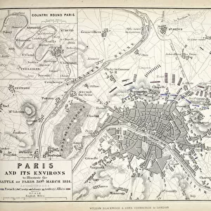
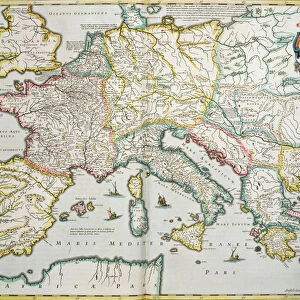
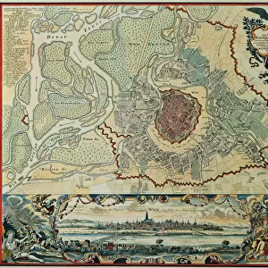
Jigsaw Puzzle : Map of the Siege of Mantua, published by William Blackwood and Sons, Edinburgh & London


![]()
Jigsaw Puzzles from Fine Art Finder
Map of the Siege of Mantua, published by William Blackwood and Sons, Edinburgh & London
746934 Map of the Siege of Mantua, published by William Blackwood and Sons, Edinburgh & London, 1848 (hand-coloured engraving) by Johnston, Alexander Keith (1804-71); Private Collection; (add.info.: Siege of Mantua (1796-97)
); The Stapleton Collection; Scottish, out of copyright
Media ID 23484072
© The Stapleton Collection / Bridgeman Images
Aerial View Armies French Revolutionary Wars Mapping Napoleon Positions War Of The First Coalition Italian Campaigns
Jigsaw Puzzle (520 Pieces)
Discover the rich historical detail of the past with our exquisite jigsaw puzzle from Media Storehouse. Featuring a captivating image of the Map of the Siege of Mantua, published by William Blackwood and Sons in 1848. This intricately hand-colored engraving by Johnston transports you back to the pivotal moment in history when the city of Mantua was under siege. Engage in a stimulating puzzle experience, perfect for history enthusiasts and puzzle lovers alike. Immerse yourself in the intricacies of the past and bring this piece of history to life in your own home.
Made in the USA, 520-piece puzzles measure 16" x 20" (40.6 x 50.8 cm). Every puzzle is meticulously printed on glossy photo paper, which has a strong 1.33 mm thickness. Delivered in a black storage cardboard box, these puzzles are both stylish and practical. (Note: puzzles contain small parts and are not suitable for children under 3 years of age.)
Jigsaw Puzzles are an ideal gift for any occasion
Estimated Product Size is 50.8cm x 40.5cm (20" x 15.9")
These are individually made so all sizes are approximate
Artwork printed orientated as per the preview above, with landscape (horizontal) or portrait (vertical) orientation to match the source image.
FEATURES IN THESE COLLECTIONS
> Fine Art Finder
> Artists
> Alexander Keith Johnston
> Fine Art Finder
> Maps (celestial & Terrestrial)
> Aerial Photography
> Austria
> Aerial Photography
> Related Images
> Aerial Photography
> Scotland
> Arts
> Artists
> A
> William Alexander
> Arts
> Artists
> K
> William Keith
> Europe
> Austria
> Aerial Views
EDITORS COMMENTS
This hand-coloured engraving, titled "Map of the Siege of Mantua" takes us back to a significant moment in history. Published by William Blackwood and Sons in Edinburgh & London in 1848, this print showcases the expertise of cartographer Alexander Keith Johnston. The map provides an aerial view of the intense conflict that unfolded during the Siege of Mantua between 1796 and 1797. It offers a detailed depiction of positions held by both Austrian and French armies during the war. As we examine this piece, we are transported to a time when Napoleon Bonaparte's forces clashed with their Austrian counterparts as part of the French Revolutionary Wars. Johnston's meticulous mapping skills allow us to visualize how these two powerful armies maneuvered on Italian soil. The intricately drawn lines showcase strategic movements and fortifications employed by both sides throughout this historic siege. As we delve into this eighteenth-century masterpiece, it becomes clear that it serves not only as a historical document but also as a testament to Johnston's exceptional talent for capturing complex military campaigns through his artistry. This engraving from Bridgeman Images is undoubtedly an invaluable addition to any collection dedicated to understanding European conflicts during this era.
MADE IN THE USA
Safe Shipping with 30 Day Money Back Guarantee
FREE PERSONALISATION*
We are proud to offer a range of customisation features including Personalised Captions, Color Filters and Picture Zoom Tools
SECURE PAYMENTS
We happily accept a wide range of payment options so you can pay for the things you need in the way that is most convenient for you
* Options may vary by product and licensing agreement. Zoomed Pictures can be adjusted in the Cart.