Jigsaw Puzzle > Europe > France > Canton > Saone
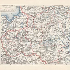
Jigsaw Puzzle : La Haute-Saone (Haute Saone, 70), Franche Comte (Franche-Comte) - France and its Colonies. Atlas illustrates one hundred and five maps from the maps of the depot of war, bridges and footwear and the Navy by M. VUILLEMIN. 1876
, Franche Comte (Franche-Comte) - France and its Colonies. Atlas illustrates one hundred and five maps from the maps of the depot of war, bridges and footwear and the Navy by M. VUILLEMIN. 1876")
, Franche Comte (Franche-Comte) - France and its Colonies. Atlas illustrates one hundred and five maps from the maps of the depot of war, bridges and footwear and the Navy by M. VUILLEMIN. 1876")


![]()
Jigsaw Puzzles from Fine Art Finder
La Haute-Saone (Haute Saone, 70), Franche Comte (Franche-Comte) - France and its Colonies. Atlas illustrates one hundred and five maps from the maps of the depot of war, bridges and footwear and the Navy by M. VUILLEMIN. 1876
XEE4144459 La Haute-Saone (Haute Saone, 70), Franche Comte (Franche-Comte) - France and its Colonies. Atlas illustrates one hundred and five maps from the maps of the depot of war, bridges and footwear and the Navy by M. VUILLEMIN. 1876. by Vuillemin, Alexandre (1812-1886); Private Collection; (add.info.: La Haute-Saone (Haute Saone, 70), Franche Comte (Franche-Comte) - France and its Colonies. Atlas illustrates one hundred and five maps from the maps of the depot of war, bridges and footwear and the Navy by M. VUILLEMIN. 1876.); Stefano Bianchetti; French, out of copyright
Media ID 25139146
© Stefano Bianchetti / Bridgeman Images
Atlas Book Franche Comt And Xe9 Franche Comte High Saone Saone Geographical Map
Jigsaw Puzzle (520 Pieces)
Discover the rich history and geography of France and its colonies with our exquisite jigsaw puzzle from Media Storehouse. Featuring an intricately detailed map from the 1876 Atlas by M. Vuillemin, this puzzle showcases one hundred and five maps from the depots of war, bridges, and the Navy. Ideal for puzzle enthusiasts and history buffs, this puzzle brings to life the beauty and complexity of La Haute-Saone (Haute Saone, 70), Franche Comte (Franche-Comte) - France and its Colonies as depicted in the classic atlas. Immerse yourself in the intricacies of the puzzle pieces and uncover the stories hidden within.
Made in the USA, 520-piece puzzles measure 16" x 20" (40.6 x 50.8 cm). Every puzzle is meticulously printed on glossy photo paper, which has a strong 1.33 mm thickness. Delivered in a black storage cardboard box, these puzzles are both stylish and practical. (Note: puzzles contain small parts and are not suitable for children under 3 years of age.)
Jigsaw Puzzles are an ideal gift for any occasion
Estimated Product Size is 50.8cm x 40.5cm (20" x 15.9")
These are individually made so all sizes are approximate
Artwork printed orientated as per the preview above, with landscape (horizontal) or portrait (vertical) orientation to match the source image.
FEATURES IN THESE COLLECTIONS
> Fine Art Finder
> Artists
> Alexandre Vuillemin
> Europe
> France
> Canton
> Saone
> Maps and Charts
> Related Images
> Services
> Royal Navy
EDITORS COMMENTS
This print showcases a historical atlas from 1876, titled "La Haute-Saone (Haute Saone, 70), Franche Comte (Franche-Comte) - France and its Colonies". The atlas, illustrated by M. VUILLEMIN, features an impressive collection of one hundred and five maps sourced from the depot of war, bridges and footwear, as well as the Navy. The intricate engravings on display provide a glimpse into the geographical landscape of La Haute-Saone in France during the late 19th century. The vibrant colors used in this map highlight various regions within Franche Comte with great detail and precision. The artist behind this masterpiece is Stefano Bianchetti. His skillful execution brings life to each map within the atlas book. This particular print captures a moment frozen in time when cartography was both an art form and a scientific endeavor. As we explore this image further, we are transported back to an era where maps were essential tools for navigation and understanding our world. It serves as a reminder of how far we have come in terms of technological advancements while appreciating the beauty that lies within these meticulously crafted pieces. This print is not only visually stunning but also holds immense historical value. It allows us to appreciate the rich heritage embedded within maps like these – artifacts that tell stories about our past while guiding us towards future discoveries.
MADE IN THE USA
Safe Shipping with 30 Day Money Back Guarantee
FREE PERSONALISATION*
We are proud to offer a range of customisation features including Personalised Captions, Color Filters and Picture Zoom Tools
SECURE PAYMENTS
We happily accept a wide range of payment options so you can pay for the things you need in the way that is most convenient for you
* Options may vary by product and licensing agreement. Zoomed Pictures can be adjusted in the Cart.