Jigsaw Puzzle > Africa > Libya > Maps
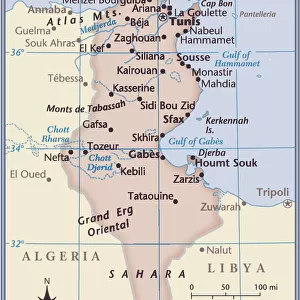
Jigsaw Puzzle : Ports and rades of the Mediterranean Sea. Detail depicting North Africa's coasts with Tunisia and Libya, map by Henri Michelot and Laurent Bremond. Municipal library of Marseille. End of the 18th century


![]()
Jigsaw Puzzles from Fine Art Finder
Ports and rades of the Mediterranean Sea. Detail depicting North Africa's coasts with Tunisia and Libya, map by Henri Michelot and Laurent Bremond. Municipal library of Marseille. End of the 18th century
JEB4874599 Ports and rades of the Mediterranean Sea. Detail depicting North Africa's coasts with Tunisia and Libya, map by Henri Michelot and Laurent Bremond. Municipal library of Marseille. End of the 18th century; (add.info.: Ports and rades of the Mediterranean Sea. Detail depicting North Africa's coasts with Tunisia and Libya, map by Henri Michelot and Laurent Bremond. Municipal library of Marseille. End of the 18th century); © Jean Bernard. All rights reserved 2023
Media ID 38166466
© © Jean Bernard. All rights reserved 2024 / Bridgeman Images
Libya Libyan Maghrebin Maghrebine Tunisia Tunisian Arab Civilization Arab Culture Arabians Geographical Map Jeanbernard Maghreb Maghrebi Maghrebian
Jigsaw Puzzle (520 Pieces)
Embark on a journey through the ports and trades of the Mediterranean Sea with our stunning jigsaw puzzle featuring a detailed map by Henri Michelot and Laurent Bremond. Perfect for history buffs and art enthusiasts alike, this puzzle captures the beauty of North Africa's coasts with Tunisia and Libya in exquisite detail. Add a touch of sophistication to your puzzling experience with this masterpiece from Fine Art Finder.
Made in the USA, 520-piece puzzles measure 16" x 20" (40.6 x 50.8 cm). Every puzzle is meticulously printed on glossy photo paper, which has a strong 1.33 mm thickness. Delivered in a black storage cardboard box, these puzzles are both stylish and practical. (Note: puzzles contain small parts and are not suitable for children under 3 years of age.)
Jigsaw Puzzles are an ideal gift for any occasion
Estimated Product Size is 50.8cm x 40.5cm (20" x 15.9")
These are individually made so all sizes are approximate
Artwork printed orientated as per the preview above, with landscape (horizontal) or portrait (vertical) orientation to match the source image.
FEATURES IN THESE COLLECTIONS
> Fine Art Finder
> Artists
> Artist Unknown
> Africa
> Libya
> Related Images
> Africa
> Tunisia
> Related Images
> Maps and Charts
> Early Maps
> Maps and Charts
> Related Images
EDITORS COMMENTS
This stunning print captures the intricate details of the ports and trade routes along the Mediterranean Sea, specifically focusing on North Africa's coasts with Tunisia and Libya. The map, created by Henri Michelot and Laurent Bremond at the end of the 18th century, is housed in the Municipal Library of Marseille.
The historical significance of this map cannot be understated as it provides a glimpse into the bustling maritime activity that once defined this region. From ancient civilizations to modern trade routes, the Mediterranean Sea has long been a hub of cultural exchange and economic prosperity.
The intricate design and meticulous attention to detail in this map showcase not only the geographical features but also highlight the rich history of Arab civilization in North Africa. The inclusion of Tunisia and Libya adds depth to our understanding of these countries' importance in shaping regional dynamics.
As we gaze upon this piece, we are transported back in time to an era where seafaring was essential for survival and prosperity. The legacy of these ports and rades lives on today, reminding us of our interconnectedness across borders and cultures. Jean Bernard's expert photography beautifully captures every nuance of this historical treasure for all to admire.
MADE IN THE USA
Safe Shipping with 30 Day Money Back Guarantee
FREE PERSONALISATION*
We are proud to offer a range of customisation features including Personalised Captions, Color Filters and Picture Zoom Tools
SECURE PAYMENTS
We happily accept a wide range of payment options so you can pay for the things you need in the way that is most convenient for you
* Options may vary by product and licensing agreement. Zoomed Pictures can be adjusted in the Cart.