Jigsaw Puzzle > Europe > United Kingdom > England > London > Museums > National Maritime Museum
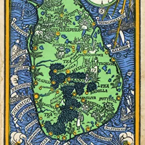
Jigsaw Puzzle : Map of Africa, India and Sri Lanka from, c.1680 (print)
")
")


![]()
Jigsaw Puzzles from Fine Art Finder
Map of Africa, India and Sri Lanka from, c.1680 (print)
7339429 Map of Africa, India and Sri Lanka from, c.1680 (print) by Doncker, Hendrick (c.1626-99); 55x64.5 cm; National Maritime Museum, London, UK; (add.info.: Creator: Hendrik Doncker
Original title: Paskaert van t westerdeel van Oost Indien streckende van Cabo de Bana Esperance tot het eyland van Cilon met al fyn omleggende eylande daar on trent); © National Maritime Museum, Greenwich, London
Media ID 38176952
© © National Maritime Museum, Greenwich, London / Bridgeman Images
Jigsaw Puzzle (520 Pieces)
Embark on a journey through history with our captivating jigsaw puzzle featuring a vintage map of Africa, India, and Sri Lanka from the 17th century. Perfect for both art lovers and history enthusiasts alike.
Made in the USA, 520-piece puzzles measure 16" x 20" (40.6 x 50.8 cm). Every puzzle is meticulously printed on glossy photo paper, which has a strong 1.33 mm thickness. Delivered in a black storage cardboard box, these puzzles are both stylish and practical. (Note: puzzles contain small parts and are not suitable for children under 3 years of age.)
Jigsaw Puzzles are an ideal gift for any occasion
Estimated Product Size is 50.8cm x 40.5cm (20" x 15.9")
These are individually made so all sizes are approximate
Artwork printed orientated as per the preview above, with landscape (horizontal) or portrait (vertical) orientation to match the source image.
FEATURES IN THESE COLLECTIONS
> Fine Art Finder
> Artists
> British School
> Fine Art Finder
> Artists
> Hendrick Doncker
> Arts
> Artists
> D
> Hendrick Doncker
> Asia
> India
> Related Images
> Asia
> Sri Lanka
> Related Images
> Europe
> United Kingdom
> England
> London
> Boroughs
> Greenwich
> Europe
> United Kingdom
> England
> London
> Museums
> Greenwich Heritage Centre
> Europe
> United Kingdom
> England
> London
> Museums
> National Maritime Museum
> Europe
> United Kingdom
> England
> London
> Towns
> Greenwich
> Europe
> United Kingdom
> Heritage Sites
> Maritime Greenwich
EDITORS COMMENTS
This stunning print of a Map of Africa, India, and Sri Lanka from circa 1680 by Hendrick Doncker is a true masterpiece of cartography. The intricate details and vibrant colors bring to life the vast expanse of land and sea depicted in this historical map.
As you gaze upon this work of art, you can't help but marvel at the skill and precision required to create such a detailed representation of these regions during the 17th century. From the coastlines to the mountain ranges, every element is meticulously rendered with accuracy and beauty.
The inclusion of India and Sri Lanka adds an extra layer of intrigue to this map, showcasing the interconnectedness of these diverse cultures and landscapes. It serves as a reminder of the rich history and heritage that has shaped these regions over centuries.
Whether you are a lover of history, geography, or art, this print is sure to captivate your imagination and transport you back in time to an era when exploration and discovery were at their peak. Display it proudly in your home or office as a testament to the enduring legacy of cartography and the wonders of our world.
MADE IN THE USA
Safe Shipping with 30 Day Money Back Guarantee
FREE PERSONALISATION*
We are proud to offer a range of customisation features including Personalised Captions, Color Filters and Picture Zoom Tools
SECURE PAYMENTS
We happily accept a wide range of payment options so you can pay for the things you need in the way that is most convenient for you
* Options may vary by product and licensing agreement. Zoomed Pictures can be adjusted in the Cart.