Jigsaw Puzzle > Animals > Fishes > Related Images
Jigsaw Puzzle : Primary cities of Europe, their population and degree of trade of individual states (print)
")
")


![]()
Jigsaw Puzzles from Fine Art Finder
Primary cities of Europe, their population and degree of trade of individual states (print)
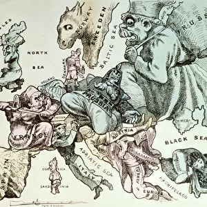
6202957 Primary cities of Europe, their population and degree of trade of individual states (print; (add.info.: CARTOGRAPHY "Primary cities of Europe, their population and degree of trade of individual states". Political map of Europe of the mid-nineteenth century, with summary description of commercial interests. Preunitary Italy is described overall: "It is divided into various states part by Italian princes and part by foreigners. Glorious country in ancient and modern stories, and from the most remote ages. He dominated the known world for no time, his ships mastered all seas. She was a teacher of science and letters and arts, and had a florid trade with suits the other nations. Although it has lapsed, however, trade is quite florid, and the Sardinian and Neapolitan navies begin to grow. It imports colonial products, salted fish, silk and cotton fabrics, canvases, cloths, goods of iron and brass, kincaglie and fashionable articles. It exports silk, oil, rice, grains, canape, dried fruits, orange trees, wines, soap, sulfur, marbles". Table VIII from "The Geography at a glance", Lithography Corbetta, Milan, 1853.); Fototeca Gilardi
Media ID 38180504
© Fototeca Gilardi / Bridgeman Images
Cyprus Denmark Economy Marketplace Policy Portugal Russian Empire Sardegna Sardinia State Turkish Culture Austria Austrian Central Turkey Kingdom Of Sardinia Prussia Turk
Jigsaw Puzzle (520 Pieces)
Embark on a journey through the bustling cities of Europe with our captivating jigsaw puzzle featuring a detailed map showcasing the primary cities, their population, and trade importance. Perfect for geography enthusiasts and puzzle lovers alike!
Made in the USA, 520-piece puzzles measure 16" x 20" (40.6 x 50.8 cm). Every puzzle is meticulously printed on glossy photo paper, which has a strong 1.33 mm thickness. Delivered in a black storage cardboard box, these puzzles are both stylish and practical. (Note: puzzles contain small parts and are not suitable for children under 3 years of age.)
Jigsaw Puzzles are an ideal gift for any occasion
Estimated Product Size is 50.8cm x 40.5cm (20" x 15.9")
These are individually made so all sizes are approximate
Artwork printed orientated as per the preview above, with landscape (horizontal) or portrait (vertical) orientation to match the source image.
FEATURES IN THESE COLLECTIONS
> Fine Art Finder
> Artists
> Edward Alfred Barton
> Animals
> Fishes
> Related Images
> Asia
> Cyprus
> Related Images
> Asia
> East Timor
> Maps
> Asia
> East Timor
> Related Images
> Asia
> Turkey
> Related Images
> Europe
> Austria
> Related Images
EDITORS COMMENTS
This print showcases the primary cities of Europe in the mid-nineteenth century, providing a detailed look at their population and degree of trade within individual states. The political map offers a glimpse into the diverse commercial interests that shaped the region during this time.
Highlighted on the map is preunitary Italy, described as a "glorious country" with a rich history of dominance in trade and commerce. Divided into various states ruled by Italian princes and foreigners, Italy was known for its flourishing trade relationships with other nations. Despite its lapse in dominance, Italy continued to engage in vibrant trade activities, importing colonial products such as silk and cotton fabrics while exporting goods like silk, oil, rice, and wines.
The intricate details provided in this map offer valuable insights into the economic landscape of Europe during the nineteenth century. From descriptions of flourishing trade routes to mentions of growing naval powers like Sardinia and Naples, this print serves as a historical treasure trove for those interested in understanding the commercial dynamics that shaped European cities during this era.
Table VIII from "The Geography at a Glance", lithographed by Corbetta in Milan 1853; Fototeca Gilardi has beautifully captured these historical nuances through their meticulous preservation of this significant piece of cartography.
MADE IN THE USA
Safe Shipping with 30 Day Money Back Guarantee
FREE PERSONALISATION*
We are proud to offer a range of customisation features including Personalised Captions, Color Filters and Picture Zoom Tools
SECURE PAYMENTS
We happily accept a wide range of payment options so you can pay for the things you need in the way that is most convenient for you
* Options may vary by product and licensing agreement. Zoomed Pictures can be adjusted in the Cart.