Jigsaw Puzzle > Maps and Charts > Early Maps
Jigsaw Puzzle : Bird s-eye view of Mesopotamia showing William Willcock


![]()
Jigsaw Puzzles from Fine Art Finder
Bird s-eye view of Mesopotamia showing William Willcock
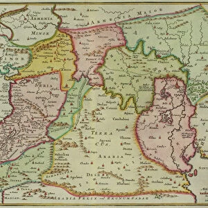
3614193 Bird s-eye view of Mesopotamia showing William Willcocks proposed scheme of irrigation, from Hutchinsons History of the Nations, pub.1915 by English School, (20th century); (add.info.: Bird s-eye view of Mesopotamia showing William Willcocks proposed scheme of irrigation. In addition to the construction of the Hindia Barrage, it includes the suggestion of drawing the flood water of the Euphrates and the Tigris into two depressions which would act as natural reservoirs and prevent flooding. From Hutchinsons History of the Nations, published 1915.); English, out of copyright
Media ID 23006774
© Bridgeman Images
Barrage Birds Eye Civil Euphrates Flood Flooding Irrigation Mesopotamia Prevent Proposed Reservoirs Scheme Tigris William
Jigsaw Puzzle (520 Pieces)
Discover the rich history of Mesopotamia with our captivating jigsaw puzzle from Media Storehouse. Featuring an intricate bird's-eye view of the region, this puzzle showcases William Willcocks proposed irrigation scheme, as depicted in the classic Hutchinson's History of the Nations. Immerse yourself in the intricacies of this Fine Art Finder image by Ken Welsh, bringing the past to life piece by piece. Perfect for history enthusiasts, puzzle lovers, or anyone seeking a challenging and rewarding pastime.
Made in the USA, 520-piece puzzles measure 16" x 20" (40.6 x 50.8 cm). Every puzzle is meticulously printed on glossy photo paper, which has a strong 1.33 mm thickness. Delivered in a black storage cardboard box, these puzzles are both stylish and practical. (Note: puzzles contain small parts and are not suitable for children under 3 years of age.)
Jigsaw Puzzles are an ideal gift for any occasion
Estimated Product Size is 40.5cm x 50.8cm (15.9" x 20")
These are individually made so all sizes are approximate
Artwork printed orientated as per the preview above, with landscape (horizontal) or portrait (vertical) orientation to match the source image.
FEATURES IN THESE COLLECTIONS
> Fine Art Finder
> Artists
> English School
> Maps and Charts
> Early Maps
> Maps and Charts
> Related Images
EDITORS COMMENTS
This print offers a mesmerizing bird's-eye view of Mesopotamia, showcasing William Willcocks' visionary scheme of irrigation. Published in 1915 as part of Hutchinson's History of the Nations, this historical illustration sheds light on a proposed plan that aimed to revolutionize water management in the region. The image depicts not only the Hindia Barrage construction but also an ingenious suggestion by Willcocks himself. He envisioned drawing flood waters from both the Euphrates and Tigris rivers into two strategically placed depressions acting as natural reservoirs. This innovative approach would effectively prevent devastating flooding while harnessing nature's abundance for controlled irrigation. As we delve into this early 20th-century engineering marvel, it becomes evident that Willcocks' proposal was more than just a blueprint; it embodied a civilizational leap forward. The intricate map showcases his comprehensive understanding of Mesopotamia's hydrological dynamics and highlights his determination to transform its landscape through intelligent water management. This photograph stands as a testament to human ingenuity and our ceaseless quest for progress. It serves as a reminder that throughout history, individuals like William Willcocks have shaped our world with their audacious ideas and unwavering dedication to solving complex challenges. Ken Welsh's expertly captured print preserves this significant moment in time, allowing us to appreciate the magnitude of Willcock's vision and its potential impact on one of humanity's oldest civilizations – Mesopotamia.
MADE IN THE USA
Safe Shipping with 30 Day Money Back Guarantee
FREE PERSONALISATION*
We are proud to offer a range of customisation features including Personalised Captions, Color Filters and Picture Zoom Tools
SECURE PAYMENTS
We happily accept a wide range of payment options so you can pay for the things you need in the way that is most convenient for you
* Options may vary by product and licensing agreement. Zoomed Pictures can be adjusted in the Cart.