Jigsaw Puzzle > Arts > Artists > W > Frederick de Wit
Jigsaw Puzzle : Map of East India (South and Southeast Asia: Pakistan, India, Nepal, Bangladesh, Burma


![]()
Jigsaw Puzzles from Fine Art Finder
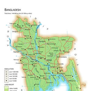
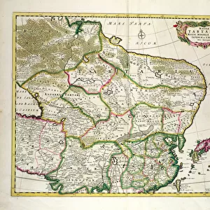
Map of East India (South and Southeast Asia: Pakistan, India, Nepal, Bangladesh, Burma
LRI4710618 Map of East India (South and Southeast Asia: Pakistan, India, Nepal, Bangladesh, Burma, Sri Lanka, Thailand, Malaysia, Vietnam, Cambodia, Laos, Philipines, Singapore and Indonesia) (etching, 1671) by Wit, Frederick de (1630-1706); Private Collection; (add.info.: Map of East India (South and Southeast Asia: Pakistan, India, Nepal, Bangladesh, Burma, Sri Lanka, Thailand, Malaysia, Vietnam, Cambodia, Laos, Philipines, Singapore and Indonesia) - Strong water extracted from " Theatrum Orbis", 1671, by Frederick De Wit (Frederico de Witt) (1630-1706)); Luisa Ricciarini; Dutch, out of copyright
Media ID 22278608
© Luisa Ricciarini / Bridgeman Images
Atlas Book Bangladesh Burma Burmese Cambodia Cambodian Indonesia Indonesian Laos Malaysia Nepal Pakistan Pakistani Philippines Sri Lanka Thai Thailand Viet Nam Vietnam Vietnamese Asian Asian Geographical Map
Jigsaw Puzzle (520 Pieces)
Discover the rich history and cultural diversity of South Asia with our stunning Jigsaw Puzzle from Media Storehouse. Featuring an intricately detailed map of East India, this puzzle showcases the regions of Pakistan, India, Nepal, Bangladesh, Burma, Sri Lanka, Thailand, Malaysia, Vietnam, Cambodia, Laos, and the Philippines. This beautiful puzzle, based on the artwork "Map of East India (South and Southeast Asia: Pakistan, India, Nepal, Bangladesh, Burma, Sri Lanka, Thailand, Malaysia, Vietnam, Cambodia, Laos, Philipines" by Luisa Ricciarini from Fine Art Finder, offers a challenging yet rewarding experience for puzzle enthusiasts. Bring the exotic beauty of this region into your home and enjoy the therapeutic benefits of piecing together this captivating puzzle.
Made in the USA, 520-piece puzzles measure 16" x 20" (40.6 x 50.8 cm). Every puzzle is meticulously printed on glossy photo paper, which has a strong 1.33 mm thickness. Delivered in a black storage cardboard box, these puzzles are both stylish and practical. (Note: puzzles contain small parts and are not suitable for children under 3 years of age.)
Jigsaw Puzzles are an ideal gift for any occasion
Estimated Product Size is 50.8cm x 40.5cm (20" x 15.9")
These are individually made so all sizes are approximate
Artwork printed orientated as per the preview above, with landscape (horizontal) or portrait (vertical) orientation to match the source image.
FEATURES IN THESE COLLECTIONS
> Fine Art Finder
> Artists
> Frederick de Wit
> Fine Art Finder
> Artists
> Jean-Baptiste Nolin
> Animals
> Mammals
> Muridae
> Water Mouse
> Arts
> Artists
> C
> Cambodian Cambodian
> Arts
> Artists
> W
> Frederick de Wit
> Asia
> Bangladesh
> Maps
> Asia
> Bangladesh
> Related Images
> Asia
> Cambodia
> Related Images
> Asia
> India
> Related Images
EDITORS COMMENTS
This print showcases a remarkable historical artifact, the "Map of East India" created by Frederick de Wit in 1671. The intricate etching depicts the vast region of South and Southeast Asia, encompassing present-day countries such as Pakistan, India, Nepal, Bangladesh, Burma (now Myanmar), Sri Lanka, Thailand, Malaysia, Vietnam, Cambodia, Laos, Philippines, Singapore and Indonesia. The map's exquisite details highlight the geographical diversity and cultural richness of this extensive area. It serves as a valuable resource for understanding the complex history and interconnectedness of these nations. Each border is meticulously drawn to accurately represent their boundaries during that era. Frederick de Wit's expertise in cartography is evident through his precise rendering of coastlines and rivers. This map was extracted from his renowned work "Theatrum Orbis" which solidified his reputation as one of the most influential Dutch cartographers. Luisa Ricciarini has beautifully captured this piece with her camera lens while preserving its authenticity. Through her lensmanship skills and attention to detail, she allows us to appreciate not only the artistic value but also the historical significance embedded within this ancient map. As we gaze upon this print today, we are transported back in time to an era when exploration was at its peak. It reminds us of how far we have come in our understanding of geography while honoring those who paved the way for our knowledge about these lands.
MADE IN THE USA
Safe Shipping with 30 Day Money Back Guarantee
FREE PERSONALISATION*
We are proud to offer a range of customisation features including Personalised Captions, Color Filters and Picture Zoom Tools
SECURE PAYMENTS
We happily accept a wide range of payment options so you can pay for the things you need in the way that is most convenient for you
* Options may vary by product and licensing agreement. Zoomed Pictures can be adjusted in the Cart.