Jigsaw Puzzle > Europe > Macedonia > Maps
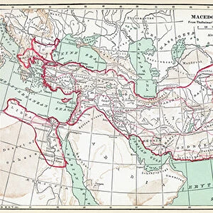
Jigsaw Puzzle : Map of Macedonia and adjacent districts. From Cassell's Universal History, published 1888 (b/w engraving)
")
")


![]()
Jigsaw Puzzles from Fine Art Finder
Map of Macedonia and adjacent districts. From Cassell's Universal History, published 1888 (b/w engraving)
6867237 Map of Macedonia and adjacent districts. From Cassell's Universal History, published 1888 (b/w engraving); (add.info.: Map of Macedonia and adjacent districts. From Cassell's Universal History, published 1888.); Photo © Ken Welsh. All rights reserved 2024
Media ID 38333678
© © Ken Welsh. All rights reserved 2024 / Bridgeman Images
Macedonia Macedonian Macedonians Geographer
Jigsaw Puzzle (1014 Pieces)
Embark on a journey through history with our captivating jigsaw puzzle featuring a vintage map of Macedonia and adjacent districts. Perfect for history buffs and puzzle enthusiasts alike, this intricate design by Ken Welsh from Fine Art Finder will provide hours of entertainment and education.
Made in the USA, 1014-piece puzzles measure 20" x 30" (50.8 x 76.2 cm). Every puzzle is meticulously printed on glossy photo paper, which has a strong 1.33 mm thickness. Delivered in a black storage cardboard box, these puzzles are both stylish and practical. (Note: puzzles contain small parts and are not suitable for children under 3 years of age.)
Jigsaw Puzzles are an ideal gift for any occasion
Estimated Product Size is 76cm x 50.8cm (29.9" x 20")
These are individually made so all sizes are approximate
Artwork printed orientated as per the preview above, with landscape (horizontal) orientation to match the source image.
FEATURES IN THESE COLLECTIONS
> Fine Art Finder
> Artists
> Jean Delville
> Europe
> Macedonia
> Posters
> Europe
> Macedonia
> Related Images
> Maps and Charts
> Early Maps
> Maps and Charts
> North Macedonia
> Maps and Charts
> Related Images
EDITORS COMMENTS
This stunning engraving from Cassell's Universal History, published in 1888, showcases a detailed map of Macedonia and its adjacent districts. The intricate lines and markings on the map highlight the geographical features of this historic region in Europe.
Macedonia, known for its rich history and cultural significance, is depicted with precision and accuracy in this 19th-century print. The map provides a glimpse into the past, offering viewers a chance to explore the landscapes that have shaped Macedonian identity over centuries.
The skilled craftsmanship of the engraver is evident in every detail of this artwork. From the intricate borders to the carefully labeled cities and rivers, each element has been meticulously rendered to create a visually striking representation of Macedonia.
As you study this vintage map, you can't help but be transported back in time to an era when cartography was both an art form and a scientific endeavor. The beauty of this engraving lies not only in its aesthetic appeal but also in its ability to educate and inform about the geography of Macedonia during the late 19th century.
Whether you're a history buff or simply appreciate fine art, this print is sure to captivate your imagination and inspire further exploration into the fascinating world of European cartography.
MADE IN THE USA
Safe Shipping with 30 Day Money Back Guarantee
FREE PERSONALISATION*
We are proud to offer a range of customisation features including Personalised Captions, Color Filters and Picture Zoom Tools
SECURE PAYMENTS
We happily accept a wide range of payment options so you can pay for the things you need in the way that is most convenient for you
* Options may vary by product and licensing agreement. Zoomed Pictures can be adjusted in the Cart.