Jigsaw Puzzle > North America > United States of America > New York > New York > Maps
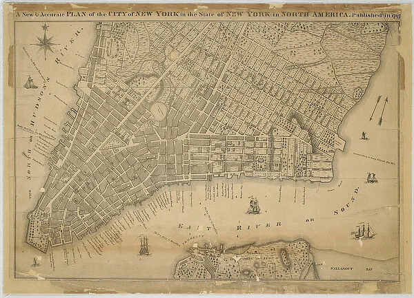
Jigsaw Puzzle : A New & Accurate Plan of the City of New York in the State of New York in North America
![]()

Jigsaw Puzzles from Fine Art Finder
A New & Accurate Plan of the City of New York in the State of New York in North America
1079247 A New & Accurate Plan of the City of New York in the State of New York in North America, Published in 1797, 1797 (black and colour ink on paper, backed with cloth) by American School, (18th century); 61x96 cm; Collection of the New-York Historical Society, USA; (add.info.: Map identifies wharves, slips, and public places.
unidentified); eNew York Historical Society; American, out of copyright
Media ID 22493256
© New York Historical Society / Bridgeman Images
Brooklyn Downtown Lower Manhattan Manhattan Pier Piers Slips Surveys Wharf Wharves
Jigsaw Puzzle (520 Pieces)
Discover the rich history of New York City with our exquisite jigsaw puzzle from Media Storehouse. Featuring an intricately detailed image of "A New & Accurate Plan of the City of New York in the State of New York in North America," published in 1797, this puzzle brings to life a captivating piece of American history. This beautifully crafted puzzle, based on the original Bridgeman Images from Fine Art Finder (1079247), offers an authentic and engaging puzzle-solving experience. Immerse yourself in the intricate details of this black and color ink on paper map, backed with cloth, and transport yourself back in time to the bustling streets of New York City in the late 18th century. Perfect for history enthusiasts, puzzle collectors, or anyone looking for a challenging and rewarding puzzle experience.
Made in the USA, 520-piece puzzles measure 16" x 20" (40.6 x 50.8 cm). Every puzzle is meticulously printed on glossy photo paper, which has a strong 1.33 mm thickness. Delivered in a black storage cardboard box, these puzzles are both stylish and practical. (Note: puzzles contain small parts and are not suitable for children under 3 years of age.)
Jigsaw Puzzles are an ideal gift for any occasion
Estimated Product Size is 50.8cm x 40.5cm (20" x 15.9")
These are individually made so all sizes are approximate
Artwork printed orientated as per the preview above, with landscape (horizontal) or portrait (vertical) orientation to match the source image.
FEATURES IN THESE COLLECTIONS
> Fine Art Finder
> Artists
> American School
> Fine Art Finder
> Artists
> John Jr. Randel
> Maps and Charts
> Early Maps
> Maps and Charts
> Related Images
> North America
> United States of America
> Maps
> North America
> United States of America
> New York
> New York
> Brooklyn
> Related Images
> North America
> United States of America
> New York
> New York
> Manhattan
> Related Images
> North America
> United States of America
> New York
> New York
> Maps
> North America
> United States of America
> New York
> Related Images
EDITORS COMMENTS
This print showcases "A New & Accurate Plan of the City of New York in the State of New York in North America" a historical map published in 1797. The artwork, created by an American School artist from the 18th century, measures 61x96 cm and is part of the esteemed collection at the New-York Historical Society in the USA. The map provides a fascinating glimpse into early Manhattan, depicting its bustling downtown area with meticulous detail. With black and color ink on paper backed with cloth, it offers a comprehensive survey of wharves, slips, and public places that were integral to the city's maritime activities during that era. As we delve into this visual treasure trove, we are transported back to a time when ships dominated New York City's waterfront. The piers and wharves depicted on this map served as vital hubs for trade and commerce. Lower Manhattan emerges as a vibrant town teeming with activity. Beyond its historical significance, this image also highlights Brooklyn's connection to Manhattan through bridges or ferries that facilitated transportation between these two iconic boroughs. With its rich heritage and intricate details capturing an important chapter in American history, this print serves as both an educational resource for historians and art enthusiasts alike. It stands as a testament to the enduring legacy of one of America's most dynamic cities – New York City – showcasing its evolution over centuries while reminding us of our collective past.
MADE IN THE USA
Safe Shipping with 30 Day Money Back Guarantee
FREE PERSONALISATION*
We are proud to offer a range of customisation features including Personalised Captions, Color Filters and Picture Zoom Tools
SECURE PAYMENTS
We happily accept a wide range of payment options so you can pay for the things you need in the way that is most convenient for you
* Options may vary by product and licensing agreement. Zoomed Pictures can be adjusted in the Cart.


