Jigsaw Puzzle > Arts > Artists > P > Portuguese School
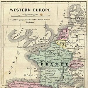
Jigsaw Puzzle : Portolan Chart of Western Europe and North Africa, c. 1580 (sepia ink and colour on vellum


![]()
Jigsaw Puzzles from Fine Art Finder
Portolan Chart of Western Europe and North Africa, c. 1580 (sepia ink and colour on vellum
986016 Portolan Chart of Western Europe and North Africa, c.1580 (sepia ink and colour on vellum) by Dutch School, (16th century); 89x73 cm; Private Collection; (add.info.: Portolan Chart of Western Europe and North Africa, illuminated manuscript. Dutch School (16th century). Sepia ink and colour on vellum. Netherlands, circa 1580. 89 x 73cm. An early Dutch chart of Western Europe and an unusual example of the influence of Portuguese style on Dutch cartography.); Photo eChristies Images; Dutch, out of copyright
Media ID 22523382
© Christie's Images / Bridgeman Images
1580 1580s Allegiance Chart Dutch School Faithful Geographic Illuminated Manuscript In Ink Ink Drawing Late Sixteenth Century Loyal Loyalty Navigational Equipment Old Masters On Vellum Patriot Patriotic Portolan Standard Western Europe Positive Concepts Sepia Ink
Jigsaw Puzzle (520 Pieces)
Discover the captivating world of exploration with our Media Storehouse Jigsaw Puzzle featuring a stunning Portolan Chart of Western Europe and North Africa from the 16th century. This intricately detailed puzzle showcases the beauty of ancient cartography, with its rich sepia tones and vibrant colors brought to life on high-quality puzzle pieces. Travel back in time as you piece together this masterpiece, revealing the intricate details of this historic map that once guided intrepid sailors on their voyages of discovery. A perfect activity for history enthusiasts, puzzle lovers, or anyone seeking an engaging and educational experience.
Made in the USA, 520-piece puzzles measure 16" x 20" (40.6 x 50.8 cm). Every puzzle is meticulously printed on glossy photo paper, which has a strong 1.33 mm thickness. Delivered in a black storage cardboard box, these puzzles are both stylish and practical. (Note: puzzles contain small parts and are not suitable for children under 3 years of age.)
Jigsaw Puzzles are an ideal gift for any occasion
Estimated Product Size is 40.5cm x 50.8cm (15.9" x 20")
These are individually made so all sizes are approximate
Artwork printed orientated as per the preview above, with landscape (horizontal) or portrait (vertical) orientation to match the source image.
FEATURES IN THESE COLLECTIONS
> Fine Art Finder
> Artists
> Dutch School
> Fine Art Finder
> Artists
> Luis Teixeira
> Fine Art Finder
> Temp Classification
> Arts
> Artists
> P
> Portuguese School
> Europe
> Netherlands
> Maps
> Europe
> Netherlands
> Posters
> Europe
> Netherlands
> Related Images
> Europe
> Portugal
> Related Images
> Maps and Charts
> Early Maps
> Maps and Charts
> Netherlands
EDITORS COMMENTS
This print showcases a remarkable piece of cartographic history - the Portolan Chart of Western Europe and North Africa, created around 1580. Measuring at an impressive 89x73 cm, this illuminated manuscript is a testament to the skill and artistry of the Dutch School in the 16th century. Rendered in sepia ink and vibrant colors on vellum, this chart offers a unique glimpse into the influence of Portuguese style on Dutch cartography during this period. It serves as both a navigational tool and a work of art, displaying intricate details that aid sailors in their journeys across treacherous waters. The close-up view highlights every meticulous stroke of ink, showcasing the dedication and precision required to create such an exquisite map. The flag proudly displayed signifies patriotism and loyalty to one's country, reflecting the spirit of exploration that characterized this era. As we delve into its intricacies, we are transported back to late sixteenth-century Europe. This chart not only provides geographical information but also evokes feelings of admiration for our ancestors' determination to explore uncharted territories. Preserved within a private collection today, this masterpiece reminds us of our rich heritage and encourages us to appreciate the advancements made by those who came before us. Its enduring beauty transcends time, serving as a reminder that maps are not merely tools but works of art capable of capturing our imagination with their historical significance.
MADE IN THE USA
Safe Shipping with 30 Day Money Back Guarantee
FREE PERSONALISATION*
We are proud to offer a range of customisation features including Personalised Captions, Color Filters and Picture Zoom Tools
SECURE PAYMENTS
We happily accept a wide range of payment options so you can pay for the things you need in the way that is most convenient for you
* Options may vary by product and licensing agreement. Zoomed Pictures can be adjusted in the Cart.