Jigsaw Puzzle > Asia > Yemen > Maps
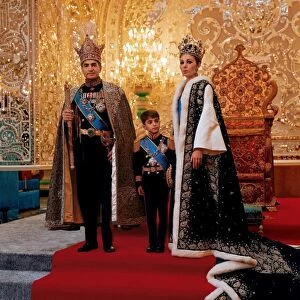
Jigsaw Puzzle : Map of Persia, Ancient and Modern (litho)
")
")


![]()
Jigsaw Puzzles from Fine Art Finder
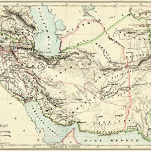
Map of Persia, Ancient and Modern (litho)
8661200 Map of Persia, Ancient and Modern (litho) by English School, (20th century); Private Collection; (add.info.: Map of Persia, Ancient and Modern. Understanding that the boundaries always greatly fluctuated, the largest extent of the Persian Empire was under (1) the Achaemenians (539-330 BC); (2) the Parthians (165 BC-AD 226); (3) the Sasanians (AD 226-651); the Mongols (AD 1256-1344). From the time of Khusru Parvez (Sasanian), AD 562, till the end of the Caliphate, 1258, Yemen (Arabia) was nominally under the suzerainty of Persia. Illustration for Hutchinson's History of the Nations (Hutchinson, c.1920).); © Look and Learn
Media ID 38110164
© © Look and Learn / Bridgeman Images
Arab Country Chronometry Comprehend Iran Iranian Iranians Persia Persians Time Timepieces Understand Understanding Understood Yemen Arab Civilization Arab Culture Arabians
Jigsaw Puzzle (520 Pieces)
Embark on a journey through time with our captivating Map of Persia jigsaw puzzle, featuring intricate details of ancient and modern Persia. Perfect for history buffs and puzzle enthusiasts alike! 🧩🗺️ #MediaStorehouse #JigsawPuzzle #PersianHistory
Made in the USA, 520-piece puzzles measure 16" x 20" (40.6 x 50.8 cm). Every puzzle is meticulously printed on glossy photo paper, which has a strong 1.33 mm thickness. Delivered in a black storage cardboard box, these puzzles are both stylish and practical. (Note: puzzles contain small parts and are not suitable for children under 3 years of age.)
Jigsaw Puzzles are an ideal gift for any occasion
Estimated Product Size is 50.8cm x 40.5cm (20" x 15.9")
These are individually made so all sizes are approximate
Artwork printed orientated as per the preview above, with landscape (horizontal) or portrait (vertical) orientation to match the source image.
FEATURES IN THESE COLLECTIONS
> Fine Art Finder
> Artists
> English School
> Fine Art Finder
> Artists
> Walter Frederick Roofe Tyndale
> Asia
> East Timor
> Maps
> Asia
> East Timor
> Related Images
> Asia
> Iran
> Related Images
> Asia
> Yemen
> Related Images
> Historic
> Ancient civilizations
> Persia (Ancient Iran)
> Historic
> Ancient civilizations
EDITORS COMMENTS
This stunning lithograph print of a Map of Persia, Ancient and Modern offers a fascinating glimpse into the historical boundaries of the Persian Empire. Created by the English School in the 20th century, this intricate map showcases the vast extent of Persian rule under various dynasties such as the Achaemenians, Parthians, Sasanians, and Mongols.
The detailed illustration highlights how these empires controlled territories that fluctuated over time, with Yemen (Arabia) falling under Persian suzerainty from AD 562 to 1258. This map was originally featured in Hutchinson's History of Nations and provides valuable insights into the complex history of Persia.
As you study this black and white depiction, you can't help but marvel at the strategic importance of Persia in shaping Middle Eastern history. From ancient civilizations to modern times, Iran has played a crucial role in regional politics and culture.
Whether you're a history buff or simply intrigued by maps, this litho print is sure to spark your curiosity about one of the world's most influential empires. Dive into the past with this artwork that captures centuries of Persian heritage and power.
MADE IN THE USA
Safe Shipping with 30 Day Money Back Guarantee
FREE PERSONALISATION*
We are proud to offer a range of customisation features including Personalised Captions, Color Filters and Picture Zoom Tools
SECURE PAYMENTS
We happily accept a wide range of payment options so you can pay for the things you need in the way that is most convenient for you
* Options may vary by product and licensing agreement. Zoomed Pictures can be adjusted in the Cart.