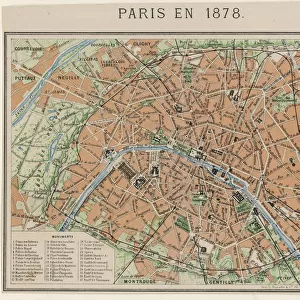
Jigsaw Puzzle > Europe > France > Paris > Maps
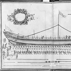
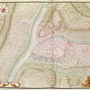
Jigsaw Puzzle : Namur, from Atlas de Louis XIV. Plans des places etrangeres, 1665 (pen


![]()
Jigsaw Puzzles from Fine Art Finder
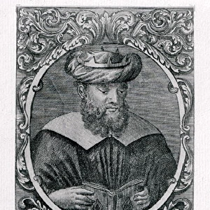
Namur, from Atlas de Louis XIV. Plans des places etrangeres, 1665 (pen
XIR271729 Namur, from Atlas de Louis XIV. Plans des places etrangeres, 1665 (pen, ink & wash) by French School, (17th century); Bibliotheque du Genie, Paris, France; (add.info.: Atlas of foreign places made for the French king, Louis XIV (1638-1715); ); French, out of copyright
Media ID 18254521
© Bibliotheque du Genie, Paris, France / Bridgeman Images
Aerial View City Walls Project Projet Wallonia
Jigsaw Puzzle (520 Pieces)
Discover the rich history and intricate details of Namur, a historic city in Belgium, with our exquisite jigsaw puzzle from Media Storehouse. This puzzle features a stunning pen, ink & wash painting from the Atlas de Louis XIV, originally created in 1665. Immerse yourself in the beauty of this fine art masterpiece as you piece together the ancient city walls, bustling markets, and picturesque buildings. A perfect activity for history enthusiasts and puzzle lovers alike.
Made in the USA, 520-piece puzzles measure 16" x 20" (40.6 x 50.8 cm). Every puzzle is meticulously printed on glossy photo paper, which has a strong 1.33 mm thickness. Delivered in a black storage cardboard box, these puzzles are both stylish and practical. (Note: puzzles contain small parts and are not suitable for children under 3 years of age.)
Jigsaw Puzzles are an ideal gift for any occasion
Estimated Product Size is 50.8cm x 40.5cm (20" x 15.9")
These are individually made so all sizes are approximate
Artwork printed orientated as per the preview above, with landscape (horizontal) or portrait (vertical) orientation to match the source image.
FEATURES IN THESE COLLECTIONS
> Fine Art Finder
> Schools
> French School
> Aerial Photography
> Belgium
> Aerial Photography
> Related Images
> Europe
> Belgium
> Aerial Views
> Europe
> Belgium
> Related Images
> Europe
> France
> Paris
> Maps
EDITORS COMMENTS
This print showcases a remarkable piece of history - Namur, as depicted in the Atlas de Louis XIV. Plans des places etrangeres from 1665. Created by the French School in the 17th century, this pen, ink, and wash artwork offers an aerial view of Namur's city walls. The intricate cartography beautifully captures the essence of this Belgian city located in Wallonia. The project was specifically commissioned for King Louis XIV, known as the Sun King (1638-1715), showcasing his fascination with foreign places. As you delve into this image, you can almost feel yourself transported back to a time when these walls were bustling with life and activity. Namur's rich history is palpable through its well-preserved fortifications depicted on this map. Each stroke of ink brings to life every detail - from the imposing structures that protected its inhabitants to the carefully planned layout of streets and buildings within. As you explore this stunning print further, take note of how it not only serves as a historical document but also as a testament to human ingenuity and architectural prowess during that era. This exceptional piece is housed at Bibliotheque du Genie in Paris, France. Let your imagination soar as you immerse yourself in this extraordinary snapshot from centuries past – an ode to both artistry and exploration.
MADE IN THE USA
Safe Shipping with 30 Day Money Back Guarantee
FREE PERSONALISATION*
We are proud to offer a range of customisation features including Personalised Captions, Color Filters and Picture Zoom Tools
SECURE PAYMENTS
We happily accept a wide range of payment options so you can pay for the things you need in the way that is most convenient for you
* Options may vary by product and licensing agreement. Zoomed Pictures can be adjusted in the Cart.