Jigsaw Puzzle > North America > United States of America > New Jersey > Paterson
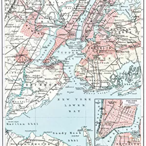
Jigsaw Puzzle : Map of New Jersey, c.1900 (engraving)
")
")


![]()
Jigsaw Puzzles from Fine Art Finder
Map of New Jersey, c.1900 (engraving)
533112 Map of New Jersey, c.1900 (engraving); (add.info.: Map of New Jersey with inset map of Jersey City, Newark and Paterson, circa 1902, from the 10th edition of Encyclopaedia Britannica.); Encyclopaedia Britannica/UIG
Media ID 38140588
© Encyclopaedia Britannica/UIG / Bridgeman Images
1902 19th Century Style Atlantic Ocean Boundary Geographical Border Guidance Illustration Technique Jersey City Navigational Equipment New Jersey Newark Old Fashioned Physical Geography State The Past Us State Border Western Script Paterson
Jigsaw Puzzle (520 Pieces)
Piece together the past with our captivating jigsaw puzzle featuring a vintage map of New Jersey from 1900. Explore the intricate details of this historical engraving and enjoy hours of entertainment as you assemble this beautiful piece of art.
Made in the USA, 520-piece puzzles measure 16" x 20" (40.6 x 50.8 cm). Every puzzle is meticulously printed on glossy photo paper, which has a strong 1.33 mm thickness. Delivered in a black storage cardboard box, these puzzles are both stylish and practical. (Note: puzzles contain small parts and are not suitable for children under 3 years of age.)
Jigsaw Puzzles are an ideal gift for any occasion
Estimated Product Size is 40.5cm x 50.8cm (15.9" x 20")
These are individually made so all sizes are approximate
Artwork printed orientated as per the preview above, with landscape (horizontal) or portrait (vertical) orientation to match the source image.
FEATURES IN THESE COLLECTIONS
> Fine Art Finder
> Temp Classification
> Arts
> Artists
> O
> Oceanic Oceanic
> Maps and Charts
> Related Images
> North America
> United States of America
> Maps
> North America
> United States of America
> New Jersey
> Jersey City
> North America
> United States of America
> New Jersey
> Newark
> North America
> United States of America
> New Jersey
> Paterson
> North America
> United States of America
> New Jersey
> Related Images
EDITORS COMMENTS
This stunning engraving of a Map of New Jersey from around 1900 is a true piece of historical art. The intricate details and craftsmanship that went into creating this map are truly remarkable, showcasing the skill and precision of cartographers from the past.
The inclusion of inset maps of Jersey City, Newark, and Paterson adds an extra layer of depth to this already detailed piece. It provides a glimpse into what these cities looked like over a century ago, offering a unique perspective on their development and growth.
The use of western script for labeling geographical features and boundaries gives this map an old-fashioned charm that is both nostalgic and informative. It serves as a reminder of how far we have come in terms of navigation technology and mapping techniques.
As you study this map, you can almost feel yourself being transported back in time to when exploration was at its peak and maps were essential tools for discovering new territories. The vertical orientation adds to the overall aesthetic appeal, making it a perfect addition to any collection or display.
Overall, this Map of New Jersey is not just a simple representation of geographic locations; it is a work of art that tells a story about the past while also serving as a guide for future generations to learn from.
MADE IN THE USA
Safe Shipping with 30 Day Money Back Guarantee
FREE PERSONALISATION*
We are proud to offer a range of customisation features including Personalised Captions, Color Filters and Picture Zoom Tools
SECURE PAYMENTS
We happily accept a wide range of payment options so you can pay for the things you need in the way that is most convenient for you
* Options may vary by product and licensing agreement. Zoomed Pictures can be adjusted in the Cart.