Jigsaw Puzzle > Arts > Artists > O > Oceanic Oceanic
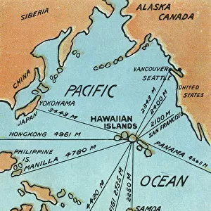
Jigsaw Puzzle : Map of Pacific Ocean Islands, c.1900 (engraving)
")
")


![]()
Jigsaw Puzzles from Fine Art Finder
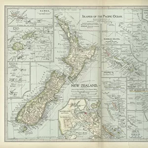
Map of Pacific Ocean Islands, c.1900 (engraving)
533048 Map of Pacific Ocean Islands, c.1900 (engraving); (add.info.: Map of Pacific Ocean Islands: New Zealand, Samoa, Fiji, Tonga, Guam, Marshall Islands, Solomon Islands, Mariana Islands, Ellice Islands, Marquesas Islands, Society Islands, and Cook Islands, circa 1902, from the 10th edition of Encyclopaedia Britannica.); Encyclopaedia Britannica/UIG
Media ID 38107306
© Encyclopaedia Britannica/UIG / Bridgeman Images
1902 19th Century Style Boundary Fiji Geographical Border Guidance Illustration Technique Mariana Islands Marquesas Islands Marshall Islands Meridian Navigational Equipment New Zealand Old Fashioned Pacific Ocean Physical Geography Samoa Society Islands Solomon Islands The Past Tonga Western Script Cook Islands Guam
Jigsaw Puzzle (520 Pieces)
Embark on a journey through the Pacific Ocean Islands with our captivating jigsaw puzzle featuring a vintage map from 1900. Explore the beauty and history of New Zealand, Samoa, Fiji, Tonga, Guam, Marshall Islands, Solomon Islands, and Mariana Islands in stunning detail. Perfect for both puzzle enthusiasts and lovers of geography alike.
Made in the USA, 520-piece puzzles measure 16" x 20" (40.6 x 50.8 cm). Every puzzle is meticulously printed on glossy photo paper, which has a strong 1.33 mm thickness. Delivered in a black storage cardboard box, these puzzles are both stylish and practical. (Note: puzzles contain small parts and are not suitable for children under 3 years of age.)
Jigsaw Puzzles are an ideal gift for any occasion
Estimated Product Size is 50.8cm x 40.5cm (20" x 15.9")
These are individually made so all sizes are approximate
Artwork printed orientated as per the preview above, with landscape (horizontal) or portrait (vertical) orientation to match the source image.
FEATURES IN THESE COLLECTIONS
> Fine Art Finder
> Temp Classification
> Arts
> Artists
> O
> Oceanic Oceanic
> Maps and Charts
> Related Images
> Oceania
> Fiji
> Related Images
> Oceania
> Marshall Islands
> Maps
> Oceania
> Marshall Islands
> Marshall Islands Heritage Sites
> Bikini Atoll Nuclear Test Site
> Oceania
> New Zealand
> Maps
> Oceania
> New Zealand
> Related Images
EDITORS COMMENTS
This stunning engraving from c.1900 depicts a detailed map of the Pacific Ocean Islands, showcasing the beauty and diversity of this vast region. From New Zealand to Samoa, Fiji to Guam, each island is intricately illustrated with precision and care.
The map, originally featured in the 10th edition of Encyclopaedia Britannica, offers a glimpse into the geographical knowledge and exploration of the time. Navigational equipment such as meridians and boundaries are clearly marked, providing valuable guidance for sailors and explorers alike.
The old-fashioned style of cartography adds a sense of nostalgia to this historical piece, transporting us back to an era when maps were meticulously hand-drawn works of art. The intricate details of coastlines and physical geography highlight the importance placed on accurate representation in an age before modern technology.
As we gaze upon this enchanting map, we are reminded of the rich history and cultural significance of each island depicted. From the Society Islands to the Mariana Islands, each holds its own unique story waiting to be discovered.
This print serves as a timeless reminder of our interconnected world and the endless possibilities that lie beyond our shores. It invites us to embark on our own journey of exploration and discovery, just as those who first navigated these waters centuries ago.
MADE IN THE USA
Safe Shipping with 30 Day Money Back Guarantee
FREE PERSONALISATION*
We are proud to offer a range of customisation features including Personalised Captions, Color Filters and Picture Zoom Tools
SECURE PAYMENTS
We happily accept a wide range of payment options so you can pay for the things you need in the way that is most convenient for you
* Options may vary by product and licensing agreement. Zoomed Pictures can be adjusted in the Cart.