Jigsaw Puzzle > Fine Art Storehouse > Map
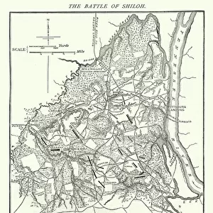
Jigsaw Puzzle : Second Boer War - Plan Ladysmith and surrounding heights


![]()
Jigsaw Puzzles from Fine Art Storehouse
Second Boer War - Plan Ladysmith and surrounding heights
Vintage engraving of a Plan Ladysmith and surrounding heights. 1899
Unleash your creativity and transform your space into a visual masterpiece!
duncan1890
Media ID 13667091
© duncan1890
1890 1899 66698 78279 94456 Anglo Boer War Boer Diagram Document Equipment Historical War Event Image Created 1890 1899 Navigational Equipment Plan Siege South Africa Southern Africa Styles Image Created 19th Century Victorian Style
Jigsaw Puzzle (520 Pieces)
Step back in time with our vintage engraving jigsaw puzzle from the Media Storehouse collection. This intriguing puzzle features "Plan Ladysmith and surrounding heights," an historical map of the Second Boer War, created by the artist duncan1890 from the Fine Art Storehouse. With intricate details and authentic textures, this puzzle is not only a fun activity for puzzle enthusiasts but also a great way to learn about this significant historical moment. Immerse yourself in the past as you piece together this captivating puzzle and display it as a beautiful conversation starter in your home.
Made in the USA, 520-piece puzzles measure 16" x 20" (40.6 x 50.8 cm). Every puzzle is meticulously printed on glossy photo paper, which has a strong 1.33 mm thickness. Delivered in a black storage cardboard box, these puzzles are both stylish and practical. (Note: puzzles contain small parts and are not suitable for children under 3 years of age.)
Jigsaw Puzzles are an ideal gift for any occasion
Estimated Product Size is 40.5cm x 50.8cm (15.9" x 20")
These are individually made so all sizes are approximate
Artwork printed orientated as per the preview above, with landscape (horizontal) or portrait (vertical) orientation to match the source image.
FEATURES IN THESE COLLECTIONS
> Fine Art Storehouse
> History
> Battles & Wars
> Historcal Battle Maps and Plans
> Fine Art Storehouse
> Map
> Historical Maps
EDITORS COMMENTS
This vintage engraving captures a pivotal moment in history - the Second Boer War. The intricate illustration showcases Plan Ladysmith and its surrounding heights, providing a detailed map of the strategic points during this historical war event. Created in the 19th century style of cartography, this engraved image transports us back to a time when navigational equipment was essential for military operations. The Victorian-style artwork exudes an air of sophistication, highlighting the importance placed on documenting and understanding battle plans during that era. As we gaze upon this piece, we are reminded of the immense challenges faced by both sides involved in the Anglo-Boer conflict. Ladysmith, located in KwaZulu-Natal province of South Africa, became synonymous with siege during this war. The diagram meticulously depicts key locations and topographical features that played crucial roles in shaping the outcome of battles fought on these grounds. As we delve into history through this print, it serves as a reminder of how far we have come from those tumultuous times. It allows us to reflect on past conflicts while appreciating our present state of peace and progress. Duncan1890's artistic rendition beautifully encapsulates not only an important chapter in Southern African history but also showcases his talent for bringing historical events to life through his engravings.
MADE IN THE USA
Safe Shipping with 30 Day Money Back Guarantee
FREE PERSONALISATION*
We are proud to offer a range of customisation features including Personalised Captions, Color Filters and Picture Zoom Tools
SECURE PAYMENTS
We happily accept a wide range of payment options so you can pay for the things you need in the way that is most convenient for you
* Options may vary by product and licensing agreement. Zoomed Pictures can be adjusted in the Cart.