Jigsaw Puzzle > North America > United States of America > New York > New York > Maps
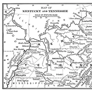
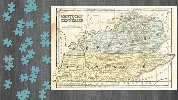
Jigsaw Puzzle : Map of Kentucky and Tennessee 1855


![]()
Jigsaw Puzzles from Fine Art Storehouse
Map of Kentucky and Tennessee 1855
System of Geography for the use of schools by Sidney E. Morse - Published by Harper & Brothers - New York 1855
Unleash your creativity and transform your space into a visual masterpiece!
THEPALMER
Media ID 13668803
© Roberto A Sanchez
Backgrounds Direction Kentucky North America Paper Patina Sepia Toned Tennessee Textured Effect Obsolete Retro Styled
Jigsaw Puzzle (1014 Pieces)
Discover the rich history of the American South with the Media Storehouse Map of Kentucky and Tennessee 1855 jigsaw puzzle, featuring a captivating image from THEPALMER's collection at the Fine Art Storehouse. This intricately detailed puzzle is based on a map from "System of Geography for the use of schools" by Sidney E. Morse, published by Harper & Brothers in New York in 1855. Piece together this historical puzzle and transport yourself back in time as you explore the borders and terrain of Kentucky and Tennessee during the mid-19th century. A perfect activity for history enthusiasts, educators, or anyone seeking a challenging and rewarding puzzle experience.
Made in the USA, 1014-piece puzzles measure 20" x 30" (50.8 x 76.2 cm). Every puzzle is meticulously printed on glossy photo paper, which has a strong 1.33 mm thickness. Delivered in a black storage cardboard box, these puzzles are both stylish and practical. (Note: puzzles contain small parts and are not suitable for children under 3 years of age.)
Jigsaw Puzzles are an ideal gift for any occasion
Estimated Product Size is 76cm x 50.8cm (29.9" x 20")
These are individually made so all sizes are approximate
Artwork printed orientated as per the preview above, with landscape (horizontal) orientation to match the source image.
FEATURES IN THESE COLLECTIONS
> Fine Art Storehouse
> The Magical World of Illustration
> Palmer Illustrated Collection
> Fine Art Storehouse
> Map
> USA Maps
> Maps and Charts
> Related Images
> North America
> Related Images
> North America
> United States of America
> Kentucky
> Related Images
> North America
> United States of America
> Maps
> North America
> United States of America
> New York
> New York
> Maps
> North America
> United States of America
> New York
> Related Images
> North America
> United States of America
> Tennessee
> Related Images
EDITORS COMMENTS
This print showcases a vintage map of Kentucky and Tennessee from the year 1855. A relic from the past, this piece is reminiscent of a time when cartography was an art form in itself. The map, originally published by Harper & Brothers in New York, was part of Sidney E. Morse's "System of Geography for the use of schools". The retro styling adds to its charm, with sepia tones and textured effects giving it an aged appearance. The paper background further enhances its nostalgic appeal, evoking memories of old atlases and dusty libraries. As you gaze at this obsolete treasure, you can't help but appreciate the intricate details that were painstakingly crafted by hand. Every contour line and river course tells a story about the physical geography of these two states. The horizontal orientation allows for easy exploration as your eyes wander across names like Nashville and Louisville, tracing their paths on this historical document. The patina that has developed over time only adds to its allure, reminding us that even maps have stories to tell. Whether you're a history enthusiast or simply captivated by the beauty of old-world cartography, this illustration transports you back to a different era in North America's history. It serves as a reminder that while technology may have changed how we navigate our world today, there is still something magical about holding an intricately designed map in your hands - even if it's just through a print like this one by THEPALMER from Fine Art Storehouse.
MADE IN THE USA
Safe Shipping with 30 Day Money Back Guarantee
FREE PERSONALISATION*
We are proud to offer a range of customisation features including Personalised Captions, Color Filters and Picture Zoom Tools
SECURE PAYMENTS
We happily accept a wide range of payment options so you can pay for the things you need in the way that is most convenient for you
* Options may vary by product and licensing agreement. Zoomed Pictures can be adjusted in the Cart.