Jigsaw Puzzle > South America > Related Images
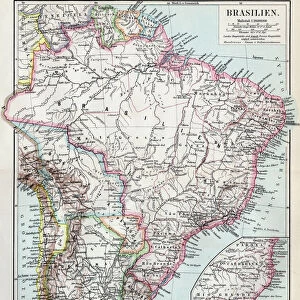
Jigsaw Puzzle : Antique Brazil


![]()
Jigsaw Puzzles from Fine Art Storehouse
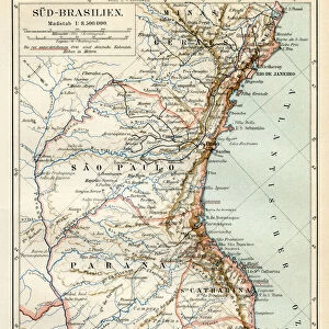
Antique Brazil
Brazil Map, - Antique style. Includes mountains and water bodies. High detail - vector illustration
Unleash your creativity and transform your space into a visual masterpiece!
Media ID 13666471
Brazil Cartographer Computer Graphics East Intricacy Land National Sketch South America Topography Vector
Jigsaw Puzzle (520 Pieces)
Discover the rich history and culture of Brazil with our exquisite Antique Brazil jigsaw puzzle from Media Storehouse's Fine Art Storehouse collection. This intricately detailed puzzle features a stunning antique map of Brazil, showcasing the beautiful terrain with its rolling mountains and sparkling water bodies. Perfect for puzzle enthusiasts and history buffs alike, this high-definition vector illustration offers a challenging and rewarding puzzle-solving experience. Immerse yourself in the past and bring the beauty of Brazil into your home.
Made in the USA, 520-piece puzzles measure 16" x 20" (40.6 x 50.8 cm). Every puzzle is meticulously printed on glossy photo paper, which has a strong 1.33 mm thickness. Delivered in a black storage cardboard box, these puzzles are both stylish and practical. (Note: puzzles contain small parts and are not suitable for children under 3 years of age.)
Jigsaw Puzzles are an ideal gift for any occasion
Estimated Product Size is 50.8cm x 40.5cm (20" x 15.9")
These are individually made so all sizes are approximate
Artwork printed orientated as per the preview above, with landscape (horizontal) or portrait (vertical) orientation to match the source image.
FEATURES IN THESE COLLECTIONS
> Fine Art Storehouse
> Map
> Historical Maps
> South America
> Related Images
EDITORS COMMENTS
This print takes us back in time to the enchanting land of Brazil. With intricate details and an antique style, this map showcases the rich topography of this South American gem. The skilled cartographer has beautifully captured the essence of Brazil's physical geography, from its majestic mountains to its winding rivers and serene lakes. The use of computer graphics gives a modern touch to this vintage piece, while still maintaining its old-world charm. The carefully engraved image adds depth and texture, making it feel like a treasured artifact from centuries past. As we explore every corner of this map, we are transported to different regions within Brazil - from the lush forests in the east to the vast sea that surrounds it. Each element is meticulously illustrated with fine ink strokes, highlighting both the natural beauty and national significance of these landmarks. Whether you're a history enthusiast or simply appreciate artistry at its finest, this antique Brazil map is sure to captivate your imagination. It serves as a reminder of our connection to the past and invites us on a journey through time. Hang it proudly on your wall and let it transport you to the enchanting landscapes that make up this incredible country.
MADE IN THE USA
Safe Shipping with 30 Day Money Back Guarantee
FREE PERSONALISATION*
We are proud to offer a range of customisation features including Personalised Captions, Color Filters and Picture Zoom Tools
SECURE PAYMENTS
We happily accept a wide range of payment options so you can pay for the things you need in the way that is most convenient for you
* Options may vary by product and licensing agreement. Zoomed Pictures can be adjusted in the Cart.