Jigsaw Puzzle > Animals > Insects > Hemiptera > Black Scale
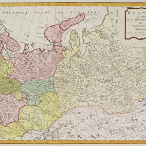
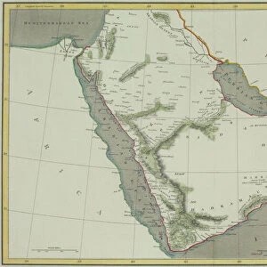
Jigsaw Puzzle : Antique map of the Black Sea and surrounding lands


![]()
Jigsaw Puzzles from Fine Art Storehouse
Antique map of the Black Sea and surrounding lands
Unleash your creativity and transform your space into a visual masterpiece!
Hemera Technologies
Media ID 13609441
© Getty Images
Black Sea Border Direction Document Geography Legend Location Place Positioning Scale
Jigsaw Puzzle (520 Pieces)
Discover the rich history and intrigue of the Black Sea and surrounding lands with our Antique Map Jigsaw Puzzle from Media Storehouse and Fine Art Storehouse. This beautifully detailed puzzle, featuring an antique map by Hemera Technologies, transports you back in time as you piece together the intricate depictions of ancient cities, historic borders, and legendary sea routes. Ideal for puzzle enthusiasts and history buffs alike, this challenging yet rewarding puzzle promises a captivating journey through time. Get ready to unlock the mysteries of the past one piece at a time.
Made in the USA, 520-piece puzzles measure 16" x 20" (40.6 x 50.8 cm). Every puzzle is meticulously printed on glossy photo paper, which has a strong 1.33 mm thickness. Delivered in a black storage cardboard box, these puzzles are both stylish and practical. (Note: puzzles contain small parts and are not suitable for children under 3 years of age.)
Jigsaw Puzzles are an ideal gift for any occasion
Estimated Product Size is 50.8cm x 40.5cm (20" x 15.9")
These are individually made so all sizes are approximate
Artwork printed orientated as per the preview above, with landscape (horizontal) or portrait (vertical) orientation to match the source image.
FEATURES IN THESE COLLECTIONS
> Fine Art Storehouse
> Map
> Historical Maps
> Animals
> Insects
> Hemiptera
> Black Scale
> Asia
> Related Images
> Maps and Charts
> Related Images
EDITORS COMMENTS
This antique map of the Black Sea and surrounding lands takes us on a journey through time, offering a glimpse into the rich history and geography of this fascinating region. Crafted with meticulous detail, this archival print showcases the artistry and precision of cartography from centuries past. The intricate engravings depict not only the physical features of the area but also provide valuable insights into its historical significance. The carefully drawn borders delineate different territories, while a key and legend help decipher the symbols used to represent various landmarks and topographical elements. As we immerse ourselves in this vintage masterpiece, we are transported back to an era when maps were hand-drawn works of art that served as both navigational tools and windows into distant lands. The horizontal composition invites us to explore every inch of this meticulously crafted document, revealing hidden gems such as Pontus Euxinus (the ancient name for the Black Sea) along with other notable locations. With no people present in this color image drawing, our focus is solely on unraveling the secrets held within its lines. Whether you are a history enthusiast or simply appreciate fine craftsmanship, this antique map offers a unique opportunity to connect with our past while adding an air of sophistication to any space it graces.
MADE IN THE USA
Safe Shipping with 30 Day Money Back Guarantee
FREE PERSONALISATION*
We are proud to offer a range of customisation features including Personalised Captions, Color Filters and Picture Zoom Tools
SECURE PAYMENTS
We happily accept a wide range of payment options so you can pay for the things you need in the way that is most convenient for you
* Options may vary by product and licensing agreement. Zoomed Pictures can be adjusted in the Cart.