Jigsaw Puzzle > Fine Art Storehouse > Map
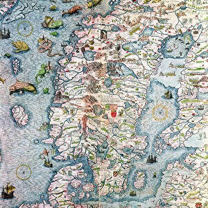
Jigsaw Puzzle : Antique map of Tabula Chersones


![]()
Jigsaw Puzzles from Fine Art Storehouse
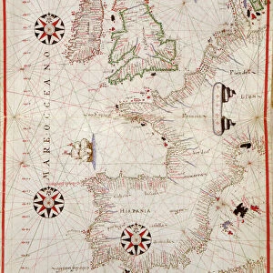
Antique map of Tabula Chersones
Unleash your creativity and transform your space into a visual masterpiece!
Hemera Technologies
Media ID 13609551
© Getty Images
Black Sea Border Crimea Direction Document Eastern Europe Geography Latitude Legend Lithuania Location Longitude Moldavia Place Positioning Scale Ukraine
Jigsaw Puzzle (520 Pieces)
Discover the captivating world of history with our Media Storehouse Antique Map of Tabula Chersones jigsaw puzzle. This intricately detailed puzzle, featuring the rare and beautiful antique map of Tabula Chersones from the Fine Art Storehouse, invites you on a journey back in time. With crisp, high-definition pieces and a rich, vibrant image from Hemera Technologies, each puzzle piece fits seamlessly into the larger picture. Solve the puzzle and adorn your home with a stunning work of art that transports you to the heart of ancient geography. Experience the thrill of discovery with every piece you place. Puzzle solving has never been more rewarding.
Made in the USA, 520-piece puzzles measure 16" x 20" (40.6 x 50.8 cm). Every puzzle is meticulously printed on glossy photo paper, which has a strong 1.33 mm thickness. Delivered in a black storage cardboard box, these puzzles are both stylish and practical. (Note: puzzles contain small parts and are not suitable for children under 3 years of age.)
Jigsaw Puzzles are an ideal gift for any occasion
Estimated Product Size is 50.8cm x 40.5cm (20" x 15.9")
These are individually made so all sizes are approximate
Artwork printed orientated as per the preview above, with landscape (horizontal) or portrait (vertical) orientation to match the source image.
FEATURES IN THESE COLLECTIONS
> Fine Art Storehouse
> Map
> Historical Maps
EDITORS COMMENTS
This print showcases an exquisite antique map of Tabula Chersones, a true gem from the past. With its intricate details and stunning craftsmanship, this archival piece takes us on a journey through time to explore the rich history of Eastern Europe and Asia. The black sea borders beautifully frame this cartographic masterpiece, revealing the ancient lands of Ukraine, Moldavia, Lithuania, and beyond. Every latitude and longitude is meticulously plotted on this historic document, allowing us to trace the footsteps of explorers who once navigated these uncharted territories. As we delve deeper into this vintage lithograph, a key legend unlocks hidden secrets and provides valuable insights into the physical geography of the region. The careful positioning of each element ensures accuracy in depicting landforms and landmarks that have shaped centuries of human civilization. In vibrant color imagery captured by Hemera Technologies' skilled photography, this horizontal print transports us back in time without any distractions from modern life. No people are present within its frame; instead, it invites viewers to immerse themselves in history's embrace. Whether you are an avid collector or simply appreciate historical artifacts, this antique map print is sure to captivate your imagination with its timeless beauty. Let it adorn your walls as a testament to our shared heritage and remind you that every place has a story waiting to be discovered.
MADE IN THE USA
Safe Shipping with 30 Day Money Back Guarantee
FREE PERSONALISATION*
We are proud to offer a range of customisation features including Personalised Captions, Color Filters and Picture Zoom Tools
SECURE PAYMENTS
We happily accept a wide range of payment options so you can pay for the things you need in the way that is most convenient for you
* Options may vary by product and licensing agreement. Zoomed Pictures can be adjusted in the Cart.