Jigsaw Puzzle > Europe > Serbia > Maps
Jigsaw Puzzle : Brussels map


![]()
Jigsaw Puzzles from Fine Art Storehouse
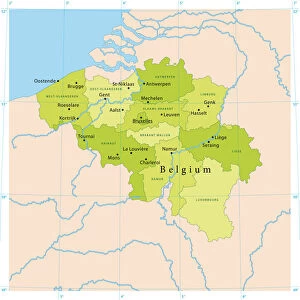
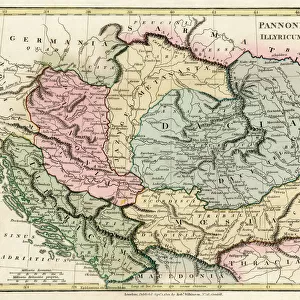
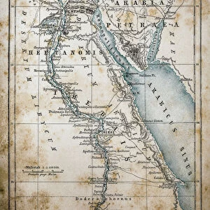
Brussels map
Illustration of a Brussels map
Unleash your creativity and transform your space into a visual masterpiece!
Nastasic
Media ID 13750703
© This content is subject to copyright
Belgium Benelux Brussels Capital Region City Map Flanders Belgium Image Date Serbia
Jigsaw Puzzle (1014 Pieces)
Discover the charm of Brussels with our captivating jigsaw puzzle from the Media Storehouse Fine Art collection. This intricately detailed puzzle, featuring the Brussels map by Nastasic, invites you on an engaging journey of exploration. Immerse yourself in the rich history and culture of this enchanting European city as you piece together the vibrant streets, historic landmarks, and hidden gems. With every completed section, the breathtaking image of Brussels comes to life, offering a satisfying sense of accomplishment. Perfect for puzzle enthusiasts of all ages, this high-quality puzzle promises a fun and rewarding experience. Unleash your inner detective and let the adventure begin!
Made in the USA, 1014-piece puzzles measure 20" x 30" (50.8 x 76.2 cm). Every puzzle is meticulously printed on glossy photo paper, which has a strong 1.33 mm thickness. Delivered in a black storage cardboard box, these puzzles are both stylish and practical. (Note: puzzles contain small parts and are not suitable for children under 3 years of age.)
Jigsaw Puzzles are an ideal gift for any occasion
Estimated Product Size is 50.8cm x 76cm (20" x 29.9")
These are individually made so all sizes are approximate
Artwork printed orientated as per the preview above, with portrait (vertical) orientation to match the source image.
FEATURES IN THESE COLLECTIONS
> Fine Art Storehouse
> Map
> Historical Maps
> Europe
> Belgium
> Related Images
> Europe
> Serbia
> Related Images
> Maps and Charts
> Related Images
EDITORS COMMENTS
This print showcases an exquisite illustration of a Brussels map, taking us back in time to the 19th century. The intricate details and delicate lines of this engraving are truly mesmerizing, capturing the essence of cartography as both an art form and a historical record. The Brussels map depicted here is not just a geographical representation but also a window into the rich history and cultural significance of Belgium's capital city. From its position within the Benelux region to its connection with Flanders, this map provides valuable insights into the geopolitical landscape of Europe during that era. The artist behind this remarkable piece is Nastasic, whose skillful use of illustration techniques such as woodcut and etching brings depth and character to every stroke. The result is a visually stunning engraved image that transports viewers through time. Whether you have an affinity for maps or simply appreciate fine art, this vertical print will undoubtedly make a striking addition to any space. Its timeless charm serves as a reminder of how our world has evolved over centuries while preserving traces of our past.
MADE IN THE USA
Safe Shipping with 30 Day Money Back Guarantee
FREE PERSONALISATION*
We are proud to offer a range of customisation features including Personalised Captions, Color Filters and Picture Zoom Tools
SECURE PAYMENTS
We happily accept a wide range of payment options so you can pay for the things you need in the way that is most convenient for you
* Options may vary by product and licensing agreement. Zoomed Pictures can be adjusted in the Cart.