Jigsaw Puzzle > Europe > Italy > Lazio > Rome
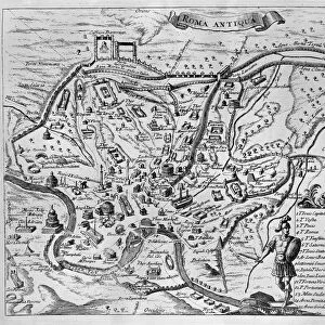
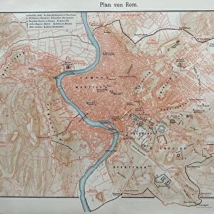
Jigsaw Puzzle : City map of ancient Rome, wood engraving, published in 1878


![]()
Jigsaw Puzzles from Fine Art Storehouse
City map of ancient Rome, wood engraving, published in 1878
City map of ancient Rome at the time of Emperor Augustus (63 BC - 14 AD). Woodcut engraving, published in 1878
Unleash your creativity and transform your space into a visual masterpiece!
ZU_09
Media ID 18292401
© ZU_09
Jigsaw Puzzle (520 Pieces)
Step back in time with our exquisite Jigsaw Puzzle from Media Storehouse - a captivating representation of ancient Rome. Featuring a detailed wood engraving of a city map published in 1878, this puzzle brings the rich history of the Roman Empire to life. Discover the architectural wonders and intricate street layouts that once graced the city during the reign of Emperor Augustus (63 BC - 14 AD). Perfect for history enthusiasts, puzzle lovers, or those seeking an engaging brain teaser, immerse yourself in this intriguing piece of the past.
Made in the USA, 520-piece puzzles measure 16" x 20" (40.6 x 50.8 cm). Every puzzle is meticulously printed on glossy photo paper, which has a strong 1.33 mm thickness. Delivered in a black storage cardboard box, these puzzles are both stylish and practical. (Note: puzzles contain small parts and are not suitable for children under 3 years of age.)
Jigsaw Puzzles are an ideal gift for any occasion
Estimated Product Size is 50.8cm x 40.5cm (20" x 15.9")
These are individually made so all sizes are approximate
Artwork printed orientated as per the preview above, with landscape (horizontal) or portrait (vertical) orientation to match the source image.
FEATURES IN THESE COLLECTIONS
> Fine Art Storehouse
> Map
> Historical Maps
> Europe
> Italy
> Lazio
> Rome
> Historic
> Ancient civilizations
> Maps and Charts
> Early Maps
> Maps and Charts
> Related Images
EDITORS COMMENTS
This print showcases a remarkable piece of history - a city map of ancient Rome during the reign of Emperor Augustus. Created through the intricate art form of wood engraving, this stunning work was published in 1878, offering us an invaluable glimpse into the capital city's layout and architecture nearly two millennia ago. As we delve into this cartographic masterpiece, we are transported back to a time when Rome stood as the epicenter of one of the greatest civilizations in human history. The carefully etched lines and detailed illustrations depict bustling streets, majestic temples, grand amphitheaters, and sprawling villas that once adorned this magnificent metropolis. Every corner tells a story; every street whispers tales from antiquity. It is awe-inspiring to imagine how life unfolded within these walls during the height of Roman power. From political intrigue at the Senate to gladiatorial spectacles at the Colosseum, this map encapsulates an entire world frozen in time. The craftsmanship evident in this woodcut engraving is truly commendable. Each stroke captures not only physical landmarks but also conveys a sense of reverence for Rome's rich heritage. This artwork serves as both an educational tool and a testament to human ingenuity throughout centuries. Whether you are fascinated by ancient civilizations or simply appreciate fine artistry, this City Map of Ancient Rome will undoubtedly captivate your imagination and transport you on an unforgettable journey through time.
MADE IN THE USA
Safe Shipping with 30 Day Money Back Guarantee
FREE PERSONALISATION*
We are proud to offer a range of customisation features including Personalised Captions, Color Filters and Picture Zoom Tools
SECURE PAYMENTS
We happily accept a wide range of payment options so you can pay for the things you need in the way that is most convenient for you
* Options may vary by product and licensing agreement. Zoomed Pictures can be adjusted in the Cart.