Jigsaw Puzzle > Maps and Charts > Related Images
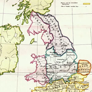
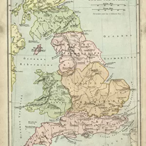
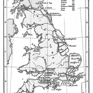
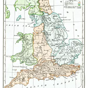
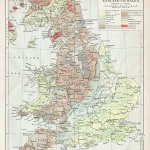
Jigsaw Puzzle : Map of Anglo-Saxon Kingdoms and the Danelaw, 9th Century


Jigsaw Puzzles from Fine Art Storehouse
Map of Anglo-Saxon Kingdoms and the Danelaw, 9th Century
Vintage engraving of a Map of Anglo-Saxon Kingdoms and the Danelaw, 9th Century
Unleash your creativity and transform your space into a visual masterpiece!
duncan1890
Media ID 14549455
© This content is subject to copyright
Jigsaw Puzzle (520 Pieces)
Discover the rich history of Anglo-Saxon England with our captivating jigsaw puzzle from Media Storehouse. This intricately detailed puzzle features a vintage engraving of a Map of Anglo-Saxon Kingdoms and the Danelaw from the 9th Century, created by the talented artist duncan1890 from Fine Art Storehouse. Journey back in time as you piece together this historical masterpiece, learning about the various Anglo-Saxon kingdoms and the areas influenced by the Danes. A perfect activity for history enthusiasts, puzzle lovers, or anyone seeking a challenging and educational pastime. Immerse yourself in the fascinating world of the Anglo-Saxon era, one puzzle piece at a time.
Made in the USA, 520-piece puzzles measure 16" x 20" (40.6 x 50.8 cm). Every puzzle is meticulously printed on glossy photo paper, which has a strong 1.33 mm thickness. Delivered in a black storage cardboard box, these puzzles are both stylish and practical. (Note: puzzles contain small parts and are not suitable for children under 3 years of age.)
Jigsaw Puzzles are an ideal gift for any occasion
Estimated Image Size (if not cropped) is 35.9cm x 50.8cm (14.1" x 20")
Estimated Product Size is 40.5cm x 50.8cm (15.9" x 20")
These are individually made so all sizes are approximate
Artwork printed orientated as per the preview above, with portrait (vertical) orientation to match the source image.
FEATURES IN THESE COLLECTIONS
> Fine Art Storehouse
> Map
> Historical Maps
> Maps and Charts
> Related Images
EDITORS COMMENTS
This vintage engraving transports us back to the 9th century, offering a glimpse into the intricate tapestry of power and influence that defined Great Britain during the Anglo-Saxon era. The print showcases a meticulously detailed map, showcasing the various Anglo-Saxon kingdoms and their territories, as well as the enigmatic Danelaw. As our eyes wander across this historical masterpiece, we are drawn to the distinct boundaries that demarcate each kingdom - from Mercia in the heartland to Wessex in the south. Each region is intricately labeled, allowing us to immerse ourselves in an ancient world where rivalries and alliances shaped destinies. The inclusion of Danelaw adds another layer of intrigue to this artwork. This area represents lands under Viking control or influence during this period, highlighting both conflict and cultural exchange between these two formidable forces. Duncan1890's expert craftsmanship breathes life into this print, capturing every minute detail with precision and finesse. The delicate lines etched on paper evoke a sense of nostalgia for bygone times when maps were hand-drawn works of art rather than digital renderings. Whether you are an avid history enthusiast or simply appreciate fine artistry, this exquisite print serves as a window into a pivotal moment in British history. It invites contemplation about how these ancient kingdoms laid foundations for modern-day England while reminding us of our shared heritage rooted deep within these storied landscapes.
MADE IN THE USA
Safe Shipping with 30 Day Money Back Guarantee
FREE PERSONALISATION*
We are proud to offer a range of customisation features including Personalised Captions, Color Filters and Picture Zoom Tools
SECURE PAYMENTS
We happily accept a wide range of payment options so you can pay for the things you need in the way that is most convenient for you
* Options may vary by product and licensing agreement. Zoomed Pictures can be adjusted in the Cart.