Jigsaw Puzzle > Oceania > Australia > Maps
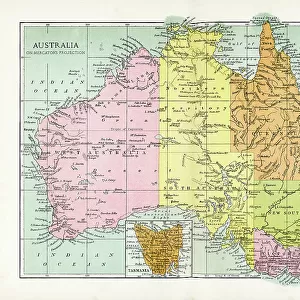
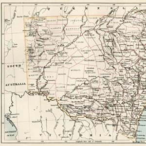
Jigsaw Puzzle : Map of Australia 1900


![]()
Jigsaw Puzzles from Fine Art Storehouse
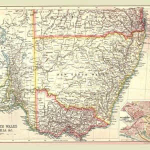
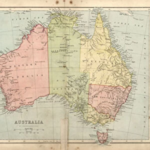
Map of Australia 1900
Meyers hand-Atlas Leipzig und Wien Verlag des Bibliographischen Instituts 1900
Unleash your creativity and transform your space into a visual masterpiece!
THEPALMER
Media ID 18106849
© 2014 Roberto Adrian Photography
Jigsaw Puzzle (520 Pieces)
Discover the rich history of Australia with our exquisite 'Map of Australia 1900' jigsaw puzzle from ThePalmer at Media Storehouse. This intriguing puzzle, sourced from the Fine Art Storehouse, is based on a rare and captivating map published in the Meyers Hand-Atlas Leipzig und Wien Verlag des Bibliographischen Instituts in 1900. Assemble the 1000+ pieces to reveal a detailed and beautifully illustrated representation of Australia's geography during this historical era. Perfect for history enthusiasts, puzzle collectors, or anyone seeking a challenging and educational pastime.
Made in the USA, 520-piece puzzles measure 16" x 20" (40.6 x 50.8 cm). Every puzzle is meticulously printed on glossy photo paper, which has a strong 1.33 mm thickness. Delivered in a black storage cardboard box, these puzzles are both stylish and practical. (Note: puzzles contain small parts and are not suitable for children under 3 years of age.)
Jigsaw Puzzles are an ideal gift for any occasion
Estimated Product Size is 50.8cm x 40.5cm (20" x 15.9")
These are individually made so all sizes are approximate
Artwork printed orientated as per the preview above, with landscape (horizontal) or portrait (vertical) orientation to match the source image.
FEATURES IN THESE COLLECTIONS
> Fine Art Storehouse
> Map
> Historical Maps
> Oceania
> Australia
> Related Images
EDITORS COMMENTS
In this print titled "Map of Australia 1900" we are transported back in time to the turn of the century. The map, originally published in Meyers Hand-Atlas Leipzig und Wien Verlag des Bibliographischen Instituts in 1900, offers a fascinating glimpse into the geographical landscape and political divisions of Australia during that era. The intricate details and delicate craftsmanship displayed on this vintage map truly make it a work of art. Every contour line, river system, and mountain range is meticulously depicted, showcasing the immense beauty and diversity found across the continent. As our eyes wander over its surface, we can almost feel ourselves embarking on an exploratory journey through uncharted territories. This particular print by THEPALMER captures not only the historical significance but also evokes a sense of nostalgia for a bygone era. It serves as a reminder of how far we have come since then while honoring the rich heritage and cultural tapestry that defines Australia today. Whether you are an avid collector or simply appreciate fine art, this exquisite print from Fine Art Storehouse is sure to be a cherished addition to any space. Its timeless appeal invites us to reflect upon our past while inspiring curiosity about what lies ahead for this vast land down under.
MADE IN THE USA
Safe Shipping with 30 Day Money Back Guarantee
FREE PERSONALISATION*
We are proud to offer a range of customisation features including Personalised Captions, Color Filters and Picture Zoom Tools
SECURE PAYMENTS
We happily accept a wide range of payment options so you can pay for the things you need in the way that is most convenient for you
* Options may vary by product and licensing agreement. Zoomed Pictures can be adjusted in the Cart.