Jigsaw Puzzle > Europe > Germany > Maps
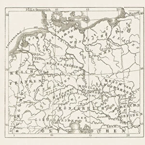
Jigsaw Puzzle : Map of Germany 1889


![]()
Jigsaw Puzzles from Fine Art Storehouse
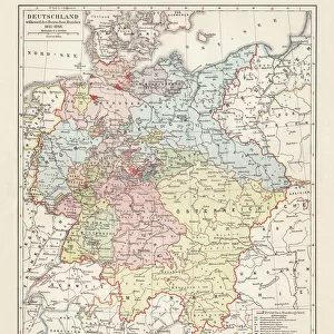
Map of Germany 1889
Comprehensive Geography by James Monteith - American Book Company 1882, 1889
Unleash your creativity and transform your space into a visual masterpiece!
THEPALMER
Media ID 18357299
Jigsaw Puzzle (520 Pieces)
Discover the rich history of Europe with our intricately designed jigsaw puzzle from the Media Storehouse range. This challenging puzzle features a captivating map of Germany from 1889, taken from the Comprehensive Geography book by James Monteith published by the American Book Company. The detailed image, sourced from THEPALMER's Fine Art Storehouse, showcases the political boundaries of Germany during that era, providing an educational and engaging puzzle experience for history enthusiasts and puzzle lovers alike. Immerse yourself in the past and put your problem-solving skills to the test with this captivating jigsaw puzzle.
Made in the USA, 520-piece puzzles measure 16" x 20" (40.6 x 50.8 cm). Every puzzle is meticulously printed on glossy photo paper, which has a strong 1.33 mm thickness. Delivered in a black storage cardboard box, these puzzles are both stylish and practical. (Note: puzzles contain small parts and are not suitable for children under 3 years of age.)
Jigsaw Puzzles are an ideal gift for any occasion
Estimated Product Size is 50.8cm x 40.5cm (20" x 15.9")
These are individually made so all sizes are approximate
Artwork printed orientated as per the preview above, with landscape (horizontal) or portrait (vertical) orientation to match the source image.
FEATURES IN THESE COLLECTIONS
> Fine Art Storehouse
> Map
> Historical Maps
> Europe
> Germany
> Related Images
> Maps and Charts
> Related Images
EDITORS COMMENTS
In this print titled "Map of Germany 1889" we are transported back in time to the late 19th century, when cartography was a meticulous art form. The map, sourced from James Monteith's renowned Comprehensive Geography published by the American Book Company in 1882 and updated in 1889, offers us a glimpse into the intricate details of Germany's geography during that era. The expert craftsmanship is evident as we observe every delicate line and carefully chosen color palette that brings this historical map to life. From the majestic peaks of the Bavarian Alps to the meandering rivers like the Rhine and Danube, each feature is meticulously rendered with precision and accuracy. As we explore this vintage treasure, it becomes apparent how much has changed over time. We can trace borders that have shifted due to political transformations while discovering cities whose names might have evolved or faded away entirely. This snapshot of history not only serves as an educational tool but also sparks our imagination about what life was like for those who inhabited these lands more than a century ago. "The Map of Germany 1889" by THEPALMER captures both nostalgia and curiosity within its frame. It reminds us of our ever-changing world while preserving a moment frozen in time—a testament to human ingenuity and exploration through cartography.
MADE IN THE USA
Safe Shipping with 30 Day Money Back Guarantee
FREE PERSONALISATION*
We are proud to offer a range of customisation features including Personalised Captions, Color Filters and Picture Zoom Tools
SECURE PAYMENTS
We happily accept a wide range of payment options so you can pay for the things you need in the way that is most convenient for you
* Options may vary by product and licensing agreement. Zoomed Pictures can be adjusted in the Cart.