Jigsaw Puzzle > Asia > India > Maps
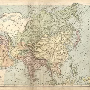
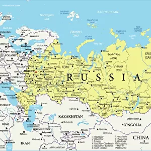
Jigsaw Puzzle : Map of India and Central Asia 1896


![]()
Jigsaw Puzzles from Fine Art Storehouse
Map of India and Central Asia 1896
Andres Allgemeiner Handatlas - Bielefeld und Leipzig 1896
Unleash your creativity and transform your space into a visual masterpiece!
THEPALMER
Media ID 18356839
Jigsaw Puzzle (520 Pieces)
Discover the rich history and cultural diversity of India and Central Asia with our captivating jigsaw puzzle from Media Storehouse. This intricately detailed puzzle features the vintage map "Map of India and Central Asia 1896" by THEPALMER from Fine Art Storehouse. Originally published in Andres Allgemeiner Handatlas - Bielefeld und Leipzig 1896, this historical puzzle is perfect for history buffs and puzzle enthusiasts alike. Assemble this puzzle to bring the intricacies of this region to life, and transport yourself back in time. Engage in a stimulating and rewarding experience as you connect the past with the present, piece by piece.
Made in the USA, 520-piece puzzles measure 16" x 20" (40.6 x 50.8 cm). Every puzzle is meticulously printed on glossy photo paper, which has a strong 1.33 mm thickness. Delivered in a black storage cardboard box, these puzzles are both stylish and practical. (Note: puzzles contain small parts and are not suitable for children under 3 years of age.)
Jigsaw Puzzles are an ideal gift for any occasion
Estimated Product Size is 40.5cm x 50.8cm (15.9" x 20")
These are individually made so all sizes are approximate
Artwork printed orientated as per the preview above, with landscape (horizontal) or portrait (vertical) orientation to match the source image.
FEATURES IN THESE COLLECTIONS
> Fine Art Storehouse
> Map
> Historical Maps
> Asia
> India
> Related Images
> Maps and Charts
> India
> Maps and Charts
> Related Images
EDITORS COMMENTS
This print showcases a vintage map titled "Map of India and Central Asia 1896" sourced from Andres Allgemeiner Handatlas - Bielefeld und Leipzig 1896. A true gem for history enthusiasts, this piece takes us back to the late 19th century, offering a glimpse into the intricate cartographic knowledge of that era. The map itself is a testament to the artistry and precision involved in creating such detailed representations before modern technology took over. With its delicate lines and meticulous labeling, it invites viewers on an exploratory journey through the vast territories of India and Central Asia as they existed more than a century ago. As we delve into this visual treasure trove, we can trace ancient trade routes, discover forgotten cities, and marvel at the diverse topography that defines these regions. From the majestic peaks of the Himalayas to the sprawling deserts of Rajasthan, every contour tells a story waiting to be unraveled. Beyond its historical significance lies an aesthetic appeal that adds charm to any space it graces. The warm sepia tones evoke nostalgia while enhancing its antique allure. Whether displayed in homes or offices, this print by THEPALMER from Fine Art Storehouse serves as both an educational tool and a conversation starter. Allow yourself to get lost in time with this remarkable artwork – let your imagination wander across borders and immerse yourself in an era long gone but forever preserved within this stunning depiction of India and Central Asia's past.
MADE IN THE USA
Safe Shipping with 30 Day Money Back Guarantee
FREE PERSONALISATION*
We are proud to offer a range of customisation features including Personalised Captions, Color Filters and Picture Zoom Tools
SECURE PAYMENTS
We happily accept a wide range of payment options so you can pay for the things you need in the way that is most convenient for you
* Options may vary by product and licensing agreement. Zoomed Pictures can be adjusted in the Cart.