Jigsaw Puzzle > Maps and Charts > Americas
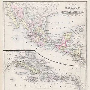
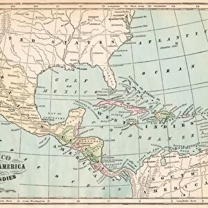
Jigsaw Puzzle : Map of Mexico and West indies 1883


![]()
Jigsaw Puzzles from Fine Art Storehouse
Map of Mexico and West indies 1883
The Eclectic Elementary Geography by Van Antwerp, Bragg & C0 / Cincinnati -New York 1883
Unleash your creativity and transform your space into a visual masterpiece!
THEPALMER
Media ID 15256729
© This content is subject to copyright
Caribbean Central America Cuba Dominican Republic Honduras Mexico Nicaragua Panama Puerto Rico West Indies
Jigsaw Puzzle (1014 Pieces)
Discover the rich history and geography of the Americas with our captivating jigsaw puzzle from Media Storehouse. This intricately detailed puzzle features the vintage map "Map of Mexico and the West Indies" by THEPALMER, originally published in "The Eclectic Elementary Geography" by Van Antwerp, Bragg & Co. in 1883. Transport yourself back in time as you piece together this beautiful and educational puzzle, making it a perfect addition to any home office, den, or classroom. Engage in a fun and rewarding experience while expanding your knowledge of the world's geography.
Made in the USA, 1014-piece puzzles measure 20" x 30" (50.8 x 76.2 cm). Every puzzle is meticulously printed on glossy photo paper, which has a strong 1.33 mm thickness. Delivered in a black storage cardboard box, these puzzles are both stylish and practical. (Note: puzzles contain small parts and are not suitable for children under 3 years of age.)
Jigsaw Puzzles are an ideal gift for any occasion
Estimated Product Size is 76cm x 50.8cm (29.9" x 20")
These are individually made so all sizes are approximate
Artwork printed orientated as per the preview above, with landscape (horizontal) orientation to match the source image.
FEATURES IN THESE COLLECTIONS
> Fine Art Storehouse
> Map
> Historical Maps
> Maps and Charts
> Related Images
> North America
> Cuba
> Maps
> North America
> Cuba
> Related Images
> North America
> Dominican Republic
> Maps
> North America
> Dominican Republic
> Related Images
> North America
> Honduras
> Maps
> North America
> Honduras
> Related Images
> North America
> Mexico
> Related Images
> North America
> Nicaragua
> Maps
EDITORS COMMENTS
In this photo print, we are transported back in time to the year 1883, where we get a glimpse of the beautifully intricate "Map of Mexico and West Indies". This remarkable piece is taken from "The Eclectic Elementary Geography" by Van Antwerp, Bragg & Co. , a renowned publication house based in Cincinnati and New York during that era. The map itself is a testament to the artistry and precision of cartography at the time. It showcases not only Mexico but also various islands and countries within the West Indies region. From Antillas to Cuba, Puerto Rico to Panama, Honduras to Nicaragua – every detail has been meticulously captured on this vintage masterpiece. As we explore this historical artifact further, it becomes evident that it holds immense educational value. The map serves as an invaluable resource for understanding the geography of Central America and Caribbean nations during the late 19th century. Its inclusion in "The Eclectic Elementary Geography" highlights its significance as an educational tool used by students across America at that time. "The Map of Mexico and West Indies" exudes a sense of nostalgia while simultaneously providing us with insights into past geopolitical landscapes. With THEPALMER's expert photography skills capturing every intricate detail with utmost clarity, this print allows us to appreciate both the beauty and historical importance embedded within this antique map.
MADE IN THE USA
Safe Shipping with 30 Day Money Back Guarantee
FREE PERSONALISATION*
We are proud to offer a range of customisation features including Personalised Captions, Color Filters and Picture Zoom Tools
SECURE PAYMENTS
We happily accept a wide range of payment options so you can pay for the things you need in the way that is most convenient for you
* Options may vary by product and licensing agreement. Zoomed Pictures can be adjusted in the Cart.